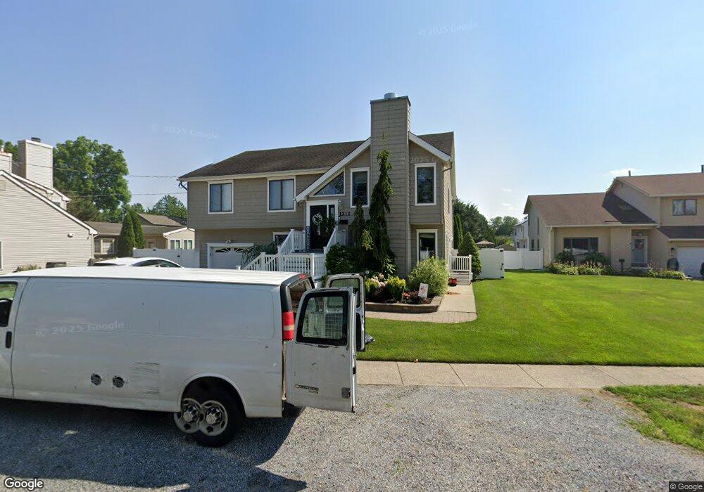
1212 Zion Rd Northfield, NJ 08225
Estimated Value: $495,000 - $710,000
--
Bed
--
Bath
3,364
Sq Ft
$173/Sq Ft
Est. Value
About This Home
This home is located at 1212 Zion Rd, Northfield, NJ 08225 and is currently estimated at $583,495, approximately $173 per square foot. 1212 Zion Rd is a home located in Atlantic County with nearby schools including Northfield Community Elementary School, Northfield Community Middle School, and Mainland Regional High School.
Ownership History
Date
Name
Owned For
Owner Type
Purchase Details
Closed on
Jan 28, 1994
Sold by
Manganiello William F
Bought by
Mann Eric and Mann Barbara
Current Estimated Value
Home Financials for this Owner
Home Financials are based on the most recent Mortgage that was taken out on this home.
Original Mortgage
$137,000
Interest Rate
7.11%
Purchase Details
Closed on
Feb 10, 1992
Sold by
Coast Development Corp
Bought by
Manganiello William F and Manganiello Janet M
Purchase Details
Closed on
Dec 5, 1991
Sold by
Coast Development Corp
Bought by
Coast Development Corp
Create a Home Valuation Report for This Property
The Home Valuation Report is an in-depth analysis detailing your home's value as well as a comparison with similar homes in the area
Home Values in the Area
Average Home Value in this Area
Purchase History
| Date | Buyer | Sale Price | Title Company |
|---|---|---|---|
| Mann Eric | $153,000 | -- | |
| Manganiello William F | $126,500 | -- | |
| Coast Development Corp | -- | -- |
Source: Public Records
Mortgage History
| Date | Status | Borrower | Loan Amount |
|---|---|---|---|
| Closed | Mann Eric | $137,000 |
Source: Public Records
Tax History Compared to Growth
Tax History
| Year | Tax Paid | Tax Assessment Tax Assessment Total Assessment is a certain percentage of the fair market value that is determined by local assessors to be the total taxable value of land and additions on the property. | Land | Improvement |
|---|---|---|---|---|
| 2025 | $10,776 | $300,000 | $59,900 | $240,100 |
| 2024 | $10,776 | $300,000 | $59,900 | $240,100 |
| 2023 | $10,476 | $300,000 | $59,900 | $240,100 |
| 2022 | $10,476 | $300,000 | $59,900 | $240,100 |
| 2021 | $10,365 | $300,000 | $59,900 | $240,100 |
| 2020 | $10,404 | $300,000 | $59,900 | $240,100 |
| 2019 | $10,227 | $300,000 | $59,900 | $240,100 |
| 2018 | $10,044 | $300,000 | $59,900 | $240,100 |
| 2017 | $9,711 | $300,000 | $59,900 | $240,100 |
| 2016 | $9,324 | $300,000 | $59,900 | $240,100 |
| 2015 | $9,195 | $300,000 | $59,900 | $240,100 |
| 2014 | $8,694 | $300,000 | $59,900 | $240,100 |
Source: Public Records
Map
Nearby Homes
- 1202 Shore Rd
- 11 Roosevelt Ave
- 219 Northfield Ave
- 221 Northfield Ave
- 1611 Shore Rd
- 147 Bonnie Lee Dr
- 1801 Tilton Rd
- 19 Locust Dr
- 202 English Ln
- 403 Park Ln
- 1907 Merritt Dr
- 309 Clark Place
- 1013 New Rd
- 5 Saint Andrews Dr
- 607 Herzel Ave
- 603 Banning Ave
- 3309 Dolphin Ave Unit 3309
- 3104 Dolphin Ave Unit 3104
- 4208 Dolphin Ave
- 600 Hollywood Dr