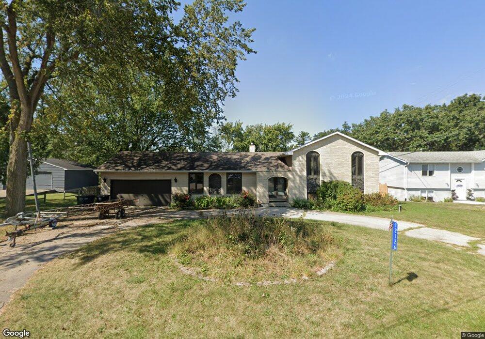
12126 219th Ave Bristol, WI 53104
Estimated Value: $433,000 - $482,000
4
Beds
3
Baths
2,100
Sq Ft
$217/Sq Ft
Est. Value
About This Home
This home is located at 12126 219th Ave, Bristol, WI 53104 and is currently estimated at $454,720, approximately $216 per square foot. 12126 219th Ave is a home located in Kenosha County with nearby schools including Salem Elementary School and Central High School.
Ownership History
Date
Name
Owned For
Owner Type
Purchase Details
Closed on
May 25, 2023
Sold by
Kaur Sukhvir
Bought by
Burke Susan C
Current Estimated Value
Purchase Details
Closed on
Mar 14, 2023
Sold by
Bogdan Marilyn C
Bought by
Kaur Sukhvir
Purchase Details
Closed on
Mar 9, 2012
Sold by
Borman Karin L
Bought by
Bogdan Macilyn C
Purchase Details
Closed on
Nov 14, 2011
Sold by
Beasy Heather
Bought by
Borman Karin L
Purchase Details
Closed on
Feb 25, 2008
Sold by
Ehley Sadie L
Bought by
Deutsche Bank National Trust Company As
Create a Home Valuation Report for This Property
The Home Valuation Report is an in-depth analysis detailing your home's value as well as a comparison with similar homes in the area
Home Values in the Area
Average Home Value in this Area
Purchase History
| Date | Buyer | Sale Price | Title Company |
|---|---|---|---|
| Burke Susan C | $385,000 | C. Wagner, Blackhawk Title Ser | |
| Kaur Sukhvir | $270,000 | C. Wagner, Blackhawk Title Ser | |
| Bogdan Macilyn C | -- | None Available | |
| Borman Karin L | $205,000 | -- | |
| Deutsche Bank National Trust Company As | $195,500 | -- |
Source: Public Records
Tax History Compared to Growth
Tax History
| Year | Tax Paid | Tax Assessment Tax Assessment Total Assessment is a certain percentage of the fair market value that is determined by local assessors to be the total taxable value of land and additions on the property. | Land | Improvement |
|---|---|---|---|---|
| 2024 | $5,445 | $377,500 | $87,000 | $290,500 |
| 2023 | $4,459 | $319,500 | $87,000 | $232,500 |
| 2022 | $5,633 | $287,000 | $83,800 | $203,200 |
| 2021 | $5,662 | $287,000 | $83,800 | $203,200 |
| 2020 | $6,098 | $292,800 | $79,200 | $213,600 |
| 2019 | $6,014 | $292,800 | $79,200 | $213,600 |
| 2018 | $5,428 | $240,000 | $75,500 | $164,500 |
| 2017 | $5,052 | $240,000 | $75,500 | $164,500 |
| 2016 | $4,950 | $220,800 | $70,900 | $149,900 |
| 2015 | $5,066 | $220,800 | $70,900 | $149,900 |
| 2014 | -- | $203,900 | $65,900 | $138,000 |
Source: Public Records
Map
Nearby Homes
- 21605 117th St
- 11621 224th Ave
- 22727 126th St
- 12725 228th Ave
- 12789 228th Ave
- Lt35 128th St
- 11736 231st Ct
- 198 Bridgewood Dr
- 12290 233rd Ave
- 188 Oakwood Dr
- 12719 234th Ave
- 324 Elmwood Ln
- 23607 125th St
- 11207 234th Ct
- 394 Birchwood Dr
- 42909 N Deep Lake Rd
- 19900 128th St Unit 210
- 19900 128th St Unit 70
- 19900 128th St Unit 124
- 19900 128th St Unit 150
- 12120 219th Ave
- 12129 219th Ave
- 12123 219th Ave
- 12133 219th Ave
- 12118 219th Ave
- 12142 219th Ave
- 12117 219th Ave
- 12110 219th Ave
- 12111 219th Ave
- 12145 219th Ave
- 21906 122nd St
- 12105 219th Ave
- 12135 220th Ave
- 21916 122nd St
- 12163 220th Ave
- 12125 220th Ave
- 21829 121st Place
- 21904 121st St
- 21925 121st St
- 21930 122nd St