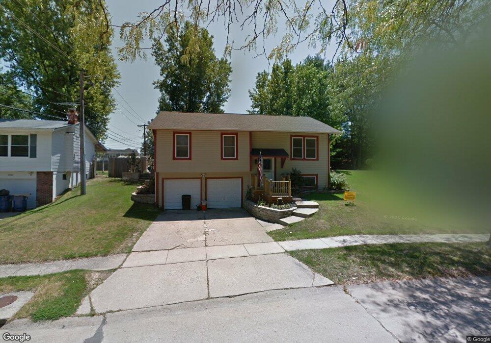
12128 Wesmeade Dr Maryland Heights, MO 63043
Estimated Value: $267,302 - $303,000
3
Beds
1
Bath
1,160
Sq Ft
$249/Sq Ft
Est. Value
About This Home
This home is located at 12128 Wesmeade Dr, Maryland Heights, MO 63043 and is currently estimated at $288,826, approximately $248 per square foot. 12128 Wesmeade Dr is a home located in St. Louis County with nearby schools including Rose Acres Elementary, Holman Middle School, and Pattonville High School.
Ownership History
Date
Name
Owned For
Owner Type
Purchase Details
Closed on
May 15, 2000
Sold by
Thus Michael G and Thus Tamra I
Bought by
Hurst Sherman L and Hurst Marjorie L
Current Estimated Value
Home Financials for this Owner
Home Financials are based on the most recent Mortgage that was taken out on this home.
Original Mortgage
$123,339
Outstanding Balance
$42,134
Interest Rate
8.19%
Mortgage Type
FHA
Estimated Equity
$246,692
Create a Home Valuation Report for This Property
The Home Valuation Report is an in-depth analysis detailing your home's value as well as a comparison with similar homes in the area
Home Values in the Area
Average Home Value in this Area
Purchase History
| Date | Buyer | Sale Price | Title Company |
|---|---|---|---|
| Hurst Sherman L | $124,000 | -- |
Source: Public Records
Mortgage History
| Date | Status | Borrower | Loan Amount |
|---|---|---|---|
| Open | Hurst Sherman L | $123,339 |
Source: Public Records
Tax History Compared to Growth
Tax History
| Year | Tax Paid | Tax Assessment Tax Assessment Total Assessment is a certain percentage of the fair market value that is determined by local assessors to be the total taxable value of land and additions on the property. | Land | Improvement |
|---|---|---|---|---|
| 2025 | $3,189 | $46,810 | $12,480 | $34,330 |
| 2024 | $3,189 | $41,810 | $9,980 | $31,830 |
| 2023 | $3,189 | $41,810 | $9,980 | $31,830 |
| 2022 | $3,141 | $37,380 | $11,630 | $25,750 |
| 2021 | $3,172 | $37,380 | $11,630 | $25,750 |
| 2020 | $2,906 | $34,560 | $9,140 | $25,420 |
| 2019 | $2,896 | $34,560 | $9,140 | $25,420 |
| 2018 | $2,439 | $26,580 | $5,830 | $20,750 |
| 2017 | $2,436 | $26,580 | $5,830 | $20,750 |
| 2016 | $2,631 | $28,230 | $7,900 | $20,330 |
| 2015 | $2,602 | $28,230 | $7,900 | $20,330 |
| 2014 | $2,484 | $27,360 | $5,530 | $21,830 |
Source: Public Records
Map
Nearby Homes
- 2444 Pheasant Run Dr
- 2427 Pheasant Run Dr
- 2517 Westrick Dr
- 2558 Pheasant Run Dr
- 2213 Rule Ave
- 12201 Dr
- 12975 Bryce Canyon Dr Unit D
- 2 Aspen II
- 2543 Wesford Dr
- 12944 Bryce Canyon Dr Unit B
- 2 Sterling at Louiselle Park
- 2234 Arborview Dr
- 2244 Canyonlands Dr Unit B
- 2244 Canyonlands Dr Unit E
- 2 Nottingham at Louiselle Park
- 12952 Bryce Canyon Dr Unit B
- 2 Hermitage II at Louiselle Park
- 2 Ashford at Louiselle Park
- 2 Royal II at Louiselle Park
- 2 Sequoia at Louiselle Park
- 12124 Wesmeade Dr
- 12132 Wesmeade Dr
- 12123 Wesland Dr
- 12120 Wesmeade Dr
- 12129 Wesland Dr
- 12117 Wesland Dr
- 12136 Wesmeade Dr
- 12131 Wesmeade Dr
- 2448 Pheasant Run Dr
- 12111 Wesland Dr
- 12123 Wesmeade Dr
- 12116 Wesmeade Dr
- 2454 Pheasant Run Dr
- 2467 Wesmeade Dr
- 12119 Wesmeade Dr
- 12107 Wesland Dr
- 2470 Wesmeade Dr
- 12110 Wesmeade Dr
- 2460 Pheasant Run Dr
- 12115 Wesmeade Dr