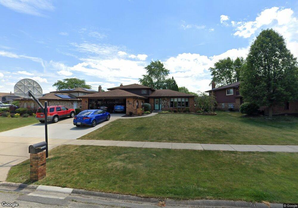
12129 Somerset Rd Orland Park, IL 60467
Estimated Value: $393,000 - $412,000
3
Beds
2
Baths
1,845
Sq Ft
$219/Sq Ft
Est. Value
About This Home
This home is located at 12129 Somerset Rd, Orland Park, IL 60467 and is currently estimated at $404,776, approximately $219 per square foot. 12129 Somerset Rd is a home located in Will County with nearby schools including Goodings Grove School, Hadley Middle School, and Homer Jr High School.
Ownership History
Date
Name
Owned For
Owner Type
Purchase Details
Closed on
Sep 28, 2022
Sold by
Jonas Robert W and Jonas April L
Bought by
Jonas Family Living Trust
Current Estimated Value
Purchase Details
Closed on
Sep 28, 2007
Sold by
Miller Daniel P and Miller Marylou T
Bought by
Jonas Robert W and Jonas April L
Home Financials for this Owner
Home Financials are based on the most recent Mortgage that was taken out on this home.
Original Mortgage
$147,000
Interest Rate
6.55%
Mortgage Type
Purchase Money Mortgage
Create a Home Valuation Report for This Property
The Home Valuation Report is an in-depth analysis detailing your home's value as well as a comparison with similar homes in the area
Home Values in the Area
Average Home Value in this Area
Purchase History
| Date | Buyer | Sale Price | Title Company |
|---|---|---|---|
| Jonas Family Living Trust | -- | -- | |
| Jonas Robert W | $305,000 | First American Title Ins Co |
Source: Public Records
Mortgage History
| Date | Status | Borrower | Loan Amount |
|---|---|---|---|
| Previous Owner | Jonas Robert W | $147,000 |
Source: Public Records
Tax History Compared to Growth
Tax History
| Year | Tax Paid | Tax Assessment Tax Assessment Total Assessment is a certain percentage of the fair market value that is determined by local assessors to be the total taxable value of land and additions on the property. | Land | Improvement |
|---|---|---|---|---|
| 2024 | $7,707 | $116,155 | $21,398 | $94,757 |
| 2023 | $7,707 | $105,289 | $19,396 | $85,893 |
| 2022 | $7,192 | $98,309 | $18,110 | $80,199 |
| 2021 | $6,843 | $93,140 | $17,158 | $75,982 |
| 2020 | $6,860 | $89,713 | $16,527 | $73,186 |
| 2019 | $6,532 | $86,304 | $15,899 | $70,405 |
| 2018 | $6,150 | $80,710 | $15,717 | $64,993 |
| 2017 | $6,033 | $78,451 | $15,277 | $63,174 |
| 2016 | $5,881 | $75,835 | $14,768 | $61,067 |
| 2015 | $5,631 | $72,989 | $14,214 | $58,775 |
| 2014 | $5,631 | $71,480 | $13,920 | $57,560 |
| 2013 | $5,631 | $71,480 | $13,920 | $57,560 |
Source: Public Records
Map
Nearby Homes
- 14225 Mallard Dr
- 11901 Windemere Ct Unit 301
- 11901 Somerset Rd Unit 2
- 11851 Windemere Ct Unit 201
- 12360 Derby Ln
- 14328 Pinewood Dr
- 14042 Churchill Dr
- 11501 W 143rd St
- 14405 Creekwood Dr
- 12009 Venetian Way
- Fremont Plan at Goodings Grove
- Eden Plan at Goodings Grove
- Danbury Plan at Goodings Grove
- Calysta Plan at Goodings Grove
- Briarcliffe Plan at Goodings Grove
- Amberwood Plan at Goodings Grove
- 11811 Old Spanish Trail
- 11637 Brookview Ln
- 13766 Mccabe Dr
- 11708 139th St
- 12135 Somerset Rd
- 12123 Somerset Rd
- 12143 Somerset Rd
- 14226 Winchester Ct
- 12113 Somerset Rd
- 12134 Somerset Rd
- 14160 Somerset Ct
- 14222 Winchester Ct
- 12118 Somerset Rd Unit 2
- 12128 Winchester Rd
- 12144 Somerset Rd
- 12105 Somerset Rd
- 12151 Somerset Rd
- 12120 Winchester Rd
- 12140 Winchester Rd
- 12110 Somerset Rd
- 12112 Somerset Rd
- 14234 Winchester Ct
- 14149 Somerset Ct
- 12065 Somerset Rd