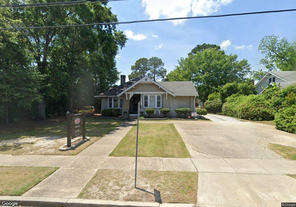
1213 Cedar Ave Columbus, GA 31906
Wynnton Village NeighborhoodEstimated Value: $200,468
Studio
1
Bath
2,591
Sq Ft
$77/Sq Ft
Est. Value
About This Home
This home is located at 1213 Cedar Ave, Columbus, GA 31906 and is currently estimated at $200,468, approximately $77 per square foot. 1213 Cedar Ave is a home located in Muscogee County with nearby schools including Richards Middle School, Hardaway High School, and Wynnton Elementary School.
Ownership History
Date
Name
Owned For
Owner Type
Purchase Details
Closed on
Sep 15, 2023
Sold by
Unkommen Partners Llc
Bought by
Supreme Property Group Llc
Current Estimated Value
Home Financials for this Owner
Home Financials are based on the most recent Mortgage that was taken out on this home.
Original Mortgage
$150,000
Outstanding Balance
$146,948
Interest Rate
7.18%
Mortgage Type
New Conventional
Estimated Equity
$53,520
Create a Home Valuation Report for This Property
The Home Valuation Report is an in-depth analysis detailing your home's value as well as a comparison with similar homes in the area
Home Values in the Area
Average Home Value in this Area
Purchase History
| Date | Buyer | Sale Price | Title Company |
|---|---|---|---|
| Supreme Property Group Llc | $180,000 | None Listed On Document |
Source: Public Records
Mortgage History
| Date | Status | Borrower | Loan Amount |
|---|---|---|---|
| Open | Supreme Property Group Llc | $150,000 |
Source: Public Records
Tax History
| Year | Tax Paid | Tax Assessment Tax Assessment Total Assessment is a certain percentage of the fair market value that is determined by local assessors to be the total taxable value of land and additions on the property. | Land | Improvement |
|---|---|---|---|---|
| 2025 | $3,237 | $82,703 | $34,292 | $48,411 |
| 2024 | $2,818 | $72,000 | $23,720 | $48,280 |
| 2023 | $4,097 | $104,004 | $34,292 | $69,712 |
| 2022 | $3,993 | $97,788 | $34,292 | $63,496 |
| 2021 | $4,081 | $89,664 | $34,292 | $55,372 |
| 2020 | $3,662 | $89,664 | $34,292 | $55,372 |
| 2019 | $3,674 | $89,664 | $34,292 | $55,372 |
| 2018 | $3,674 | $89,664 | $34,292 | $55,372 |
| 2017 | $3,685 | $89,664 | $34,292 | $55,372 |
| 2016 | $3,516 | $85,233 | $43,200 | $42,033 |
| 2015 | $3,520 | $85,233 | $43,200 | $42,033 |
| 2014 | $3,524 | $85,233 | $43,200 | $42,033 |
| 2013 | -- | $85,233 | $43,200 | $42,033 |
Source: Public Records
Map
Nearby Homes
- 1228 Cedar Ave
- 1255 Cedar Ave Unit 6
- 2134 13th St
- 2133 13th St
- 2243 14th St
- 2429 Bell St
- 1242 18th Ave
- 1254 18th Ave
- 1164 Tate Dr
- 2551 Wynnton Rd
- 2621 Lewis St
- 2726 Marion St
- 1002 Lawyers Ln
- 1500 E Dinglewood Dr
- 1620 Springer St
- 1557 18th Ave
- 1431 16th Ave
- 240 Kildee Dr
- 2304 Willard St
- 1505 16th Ave
- 2121 Wynnton Rd
- 1221 Cedar Ave
- 1225 Cedar Ave
- 1214 Cedar Ave
- 1229 Cedar Ave
- 1220 Cedar Ave
- 1235 Cedar Ave
- 1239 Cedar Ave
- 2047 Wynnton Rd
- 1211 Forest Ave
- 1234 Cedar Ave
- 1219 Forest Ave Unit 12
- 1219 Forest Ave Unit 11
- 1219 Forest Ave Unit 10
- 1219 Forest Ave Unit 9
- 1219 Forest Ave Unit 8
- 1219 Forest Ave Unit 7
- 1219 Forest Ave Unit 6
- 1219 Forest Ave Unit 5
- 1219 Forest Ave Unit 4
Your Personal Tour Guide
Ask me questions while you tour the home.