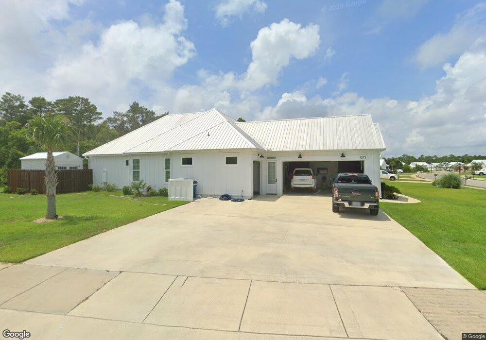
1213 Dorado Way Gulf Shores, AL 36542
Estimated Value: $477,045 - $555,000
3
Beds
3
Baths
1,908
Sq Ft
$277/Sq Ft
Est. Value
About This Home
This home is located at 1213 Dorado Way, Gulf Shores, AL 36542 and is currently estimated at $528,011, approximately $276 per square foot. 1213 Dorado Way is a home with nearby schools including Gulf Shores Elementary School, Gulf Shores Middle School, and Gulf Shores High School.
Ownership History
Date
Name
Owned For
Owner Type
Purchase Details
Closed on
Dec 4, 2020
Sold by
Baker Clark Homes Inc
Bought by
Felts Lewis R and Felts Betty E
Current Estimated Value
Purchase Details
Closed on
Apr 2, 2020
Sold by
Felts Lewis R and Felts Betty E
Bought by
Baker Clark Homes Inc
Home Financials for this Owner
Home Financials are based on the most recent Mortgage that was taken out on this home.
Original Mortgage
$260,000
Interest Rate
3.4%
Mortgage Type
Commercial
Purchase Details
Closed on
Jan 27, 2020
Sold by
Cji Llc
Bought by
Felts Lewis R and Felts Betty E
Purchase Details
Closed on
Dec 17, 2019
Sold by
Cji Llc
Bought by
Williams Isaac
Create a Home Valuation Report for This Property
The Home Valuation Report is an in-depth analysis detailing your home's value as well as a comparison with similar homes in the area
Home Values in the Area
Average Home Value in this Area
Purchase History
| Date | Buyer | Sale Price | Title Company |
|---|---|---|---|
| Felts Lewis R | $306,490 | None Available | |
| Baker Clark Homes Inc | $200,000 | None Available | |
| Felts Lewis R | -- | Professional Land Title Co | |
| Cji Llc | -- | Professional Land Title Inc | |
| Williams Isaac | -- | None Available |
Source: Public Records
Mortgage History
| Date | Status | Borrower | Loan Amount |
|---|---|---|---|
| Previous Owner | Baker Clark Homes Inc | $260,000 |
Source: Public Records
Tax History Compared to Growth
Tax History
| Year | Tax Paid | Tax Assessment Tax Assessment Total Assessment is a certain percentage of the fair market value that is determined by local assessors to be the total taxable value of land and additions on the property. | Land | Improvement |
|---|---|---|---|---|
| 2024 | $1,332 | $50,980 | $6,200 | $44,780 |
| 2023 | $1,387 | $53,060 | $6,700 | $46,360 |
| 2022 | $1,093 | $41,980 | $0 | $0 |
| 2021 | $1,007 | $35,420 | $0 | $0 |
| 2020 | $330 | $10,000 | $0 | $0 |
| 2019 | $231 | $7,000 | $0 | $0 |
| 2018 | $139 | $4,200 | $0 | $0 |
| 2017 | $116 | $3,500 | $0 | $0 |
| 2016 | $116 | $3,500 | $0 | $0 |
| 2015 | $83 | $2,500 | $0 | $0 |
| 2014 | $50 | $1,500 | $0 | $0 |
| 2013 | -- | $1,500 | $0 | $0 |
Source: Public Records
Map
Nearby Homes
- 0 Autumn Ridge Rd Unit 387934
- 1509 Sago Ct
- 1697 Colony Parke Dr
- 1691 Colony Parke Dr
- 1703 Colony Parke Dr
- 1685 Colony Parke Dr
- 1698 Colony Parke Dr
- Plan 2320 at Colony Park Estates - Colony Parke Estates
- Plan 1930 at Colony Park Estates - Colony Parke Estates
- Plan 2202 at Colony Park Estates - Colony Parke Estates
- Plan 2508 at Colony Park Estates - Colony Parke Estates
- Plan 2300 at Colony Park Estates - Colony Parke Estates
- 1530 Colony Parke Dr
- 2340 Lagoon Cir
- 1524 Colony Parke Dr
- 1523 Colony Parke Dr
- 16707 State Highway 180 Unit 67
- 16707 State Highway 180 Unit 35
- 16707 State Highway 180 Unit 66
- 16707 State Highway 180 Unit 34
- 1217 Dorado Way
- 1505 Canary Ct
- 1505 Canary Cir
- 1221 Dorado Way
- 1216 Dorado Way
- 1225 Dorado Way
- 1220 Dorado Way
- 1224 Dorado Way
- 1229 Dorado Way
- 0 Canary Ct
- 1228 Dorado Way
- 1233 Dorado Way
- 1509 Canary Ct
- 1513 Canary Ct
- 1505 Sable Ct Unit 1505 Sabal Cove Gulf
- 1517 Canary Ct
- 1521 Canary Ct
- 1521 Canary Ct
- 1245 Dorado Way
- 1232 Dorado Way