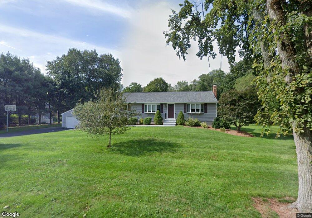
1213 Highland St Holliston, MA 01746
Estimated Value: $570,000 - $702,000
3
Beds
1
Bath
1,248
Sq Ft
$501/Sq Ft
Est. Value
About This Home
This home is located at 1213 Highland St, Holliston, MA 01746 and is currently estimated at $624,800, approximately $500 per square foot. 1213 Highland St is a home located in Middlesex County with nearby schools including Miller Elementary School, Robert H. Adams Middle School, and Holliston High School.
Ownership History
Date
Name
Owned For
Owner Type
Purchase Details
Closed on
Feb 25, 2019
Sold by
Derosa Sabato and Derosa Michele
Bought by
Derosa Income T
Current Estimated Value
Purchase Details
Closed on
May 12, 2003
Sold by
Cummings Michele and Derosa Michele
Bought by
Derosa Michele and Derosa Sabato
Purchase Details
Closed on
Feb 1, 1989
Sold by
J&N Rt
Bought by
Derosa Sabato
Home Financials for this Owner
Home Financials are based on the most recent Mortgage that was taken out on this home.
Original Mortgage
$120,750
Interest Rate
10.62%
Mortgage Type
Purchase Money Mortgage
Create a Home Valuation Report for This Property
The Home Valuation Report is an in-depth analysis detailing your home's value as well as a comparison with similar homes in the area
Home Values in the Area
Average Home Value in this Area
Purchase History
| Date | Buyer | Sale Price | Title Company |
|---|---|---|---|
| Derosa Income T | -- | -- | |
| Derosa Michele | -- | -- | |
| Derosa Sabato | $163,750 | -- |
Source: Public Records
Mortgage History
| Date | Status | Borrower | Loan Amount |
|---|---|---|---|
| Previous Owner | Derosa Sabato | $20,000 | |
| Previous Owner | Derosa Sabato | $129,600 | |
| Previous Owner | Derosa Sabato | $126,000 | |
| Previous Owner | Derosa Sabato | $120,750 |
Source: Public Records
Tax History Compared to Growth
Tax History
| Year | Tax Paid | Tax Assessment Tax Assessment Total Assessment is a certain percentage of the fair market value that is determined by local assessors to be the total taxable value of land and additions on the property. | Land | Improvement |
|---|---|---|---|---|
| 2025 | $8,375 | $571,700 | $284,700 | $287,000 |
| 2024 | $7,992 | $530,700 | $284,700 | $246,000 |
| 2023 | $7,159 | $464,900 | $237,300 | $227,600 |
| 2022 | $7,030 | $404,500 | $237,300 | $167,200 |
| 2021 | $7,069 | $396,000 | $228,600 | $167,400 |
| 2020 | $7,301 | $387,300 | $228,700 | $158,600 |
| 2019 | $6,705 | $356,100 | $199,000 | $157,100 |
| 2018 | $6,648 | $356,100 | $199,000 | $157,100 |
| 2017 | $6,108 | $329,800 | $191,200 | $138,600 |
| 2016 | $6,015 | $320,100 | $191,200 | $128,900 |
| 2015 | $5,508 | $284,200 | $149,100 | $135,100 |
Source: Public Records
Map
Nearby Homes
- 1037 Washington St
- 1014 Highland St
- 154 Union St
- 1366 Washington St
- 75 Ridge Rd
- 43 Bittersweet Cir Unit 43
- 156 Mitchell Rd
- 7 Hill St
- 160 Winter St
- 11 Francine Dr
- 0 Hill St
- 110 Bonney Dr
- 625 Norfolk St
- 20 Hargrave Ave
- 116 Winthrop St
- 56 Paul Rd
- 54 Westfield Dr
- 266 Willowgate Rise
- 56 Roy Ave
- 140 Goulding St
- 1207 Highland St
- 1205 Highland St
- 1229 Highland St
- 1230 Highland St
- 1196 Highland St
- 1173 Highland St
- 1245 Highland St
- 62 Persis Place
- 1167 Highland St
- 1159 Highland St
- 44 Persis Place
- 35 Peter St
- 64 Marked Tree Rd
- 1261 Highland St
- 24 Persis Place
- 76 Marked Tree Rd
- 1093 Washington St Unit 1093
- 1091 Washington St Unit 1091
- 1149 Highland St
- 12 Persis Place