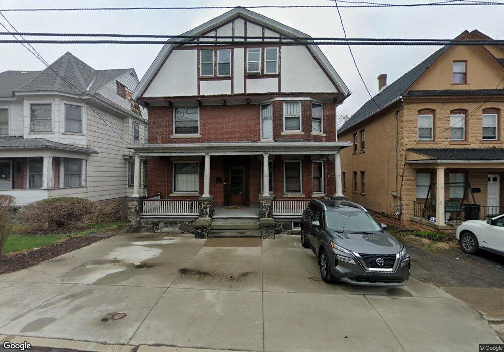
1213 S Main Ave Scranton, PA 18504
Hyde Park NeighborhoodEstimated Value: $159,000 - $298,724
--
Bed
--
Bath
3,400
Sq Ft
$68/Sq Ft
Est. Value
About This Home
This home is located at 1213 S Main Ave, Scranton, PA 18504 and is currently estimated at $229,575, approximately $67 per square foot. 1213 S Main Ave is a home located in Lackawanna County with nearby schools including Longan Elementary School, Adams Elementary School, and Frances Willard School.
Ownership History
Date
Name
Owned For
Owner Type
Purchase Details
Closed on
May 13, 2022
Sold by
Brick Ave Llc
Bought by
Trusty Andre
Current Estimated Value
Purchase Details
Closed on
May 17, 2018
Sold by
1213 S Main Ave Llc
Bought by
Brick Ave Llc
Home Financials for this Owner
Home Financials are based on the most recent Mortgage that was taken out on this home.
Original Mortgage
$61,000
Interest Rate
4.4%
Mortgage Type
Commercial
Purchase Details
Closed on
Aug 11, 2008
Sold by
Wharton Suzanne J and Aniska Suzanne J
Bought by
Wachovia Bank Na
Create a Home Valuation Report for This Property
The Home Valuation Report is an in-depth analysis detailing your home's value as well as a comparison with similar homes in the area
Home Values in the Area
Average Home Value in this Area
Purchase History
| Date | Buyer | Sale Price | Title Company |
|---|---|---|---|
| Trusty Andre | $255,000 | None Listed On Document | |
| Brick Ave Llc | $81,000 | None Available | |
| Wachovia Bank Na | $9,624 | None Available |
Source: Public Records
Mortgage History
| Date | Status | Borrower | Loan Amount |
|---|---|---|---|
| Previous Owner | Brick Ave Llc | $61,000 |
Source: Public Records
Tax History Compared to Growth
Tax History
| Year | Tax Paid | Tax Assessment Tax Assessment Total Assessment is a certain percentage of the fair market value that is determined by local assessors to be the total taxable value of land and additions on the property. | Land | Improvement |
|---|---|---|---|---|
| 2025 | $4,656 | $14,000 | $3,000 | $11,000 |
| 2024 | $4,265 | $14,000 | $3,000 | $11,000 |
| 2023 | $4,265 | $14,000 | $3,000 | $11,000 |
| 2022 | $4,171 | $14,000 | $3,000 | $11,000 |
| 2021 | $4,171 | $14,000 | $3,000 | $11,000 |
| 2020 | $4,096 | $14,000 | $3,000 | $11,000 |
| 2019 | $3,856 | $14,000 | $3,000 | $11,000 |
| 2018 | $3,856 | $14,000 | $3,000 | $11,000 |
| 2017 | $3,790 | $14,000 | $3,000 | $11,000 |
| 2016 | $1,254 | $14,000 | $3,000 | $11,000 |
| 2015 | $2,872 | $14,000 | $3,000 | $11,000 |
| 2014 | -- | $14,000 | $3,000 | $11,000 |
Source: Public Records
Map
Nearby Homes
- 610 Landis St
- 1203 Acker Ave
- 625 Landis St
- 1009 1011 Acker Ave Unit L 109
- 924 S Main Ave
- 1115 Watson St
- 1250 S 1252 6th
- 730 W Locust St
- 1234 Bryn Mawr St Unit 11
- 1143 Reynolds Ave
- 901 Eynon St
- 1227 Rundle St
- 1301 Sloan St
- LOT#16 Reynolds Ave
- Lot# 7 Reynolds Ave
- 705 Hampton St
- 816 12th Ave
- 1335 Sloan St
- 727 Fellows St
- 1021 Fellows St
- 1213 Rear S Main Ave
- 1217 S Main Ave Unit 1219
- 1209 S Main Ave Unit 1211
- 1219 S Main Ave
- 1217 S Ave
- 1217-1219 S Main Ave
- 822 Smith St
- 1225 S Main Ave
- 818 Smith St
- 1131 S Main Ave
- 1121 S Main Ave Unit 1123
- 1202 Snyder Ave Unit 4
- 816 Smith St
- 1126 Snyder Ave
- 1206 Snyder Ave
- 1122 Snyder L 21 Ave
- 1122 Snyder Ave
- 1121 S 1123 Main Ave
- 1118 Snyder Ave
- 1140-1150 S Main Ave