Estimated Value: $92,000 - $119,000
--
Bed
1
Bath
1,110
Sq Ft
$94/Sq Ft
Est. Value
About This Home
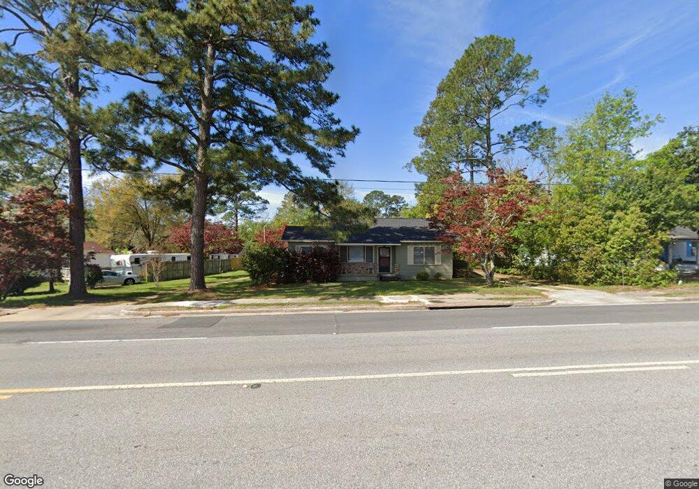
This home is located at 1213 Us Highway 84 W, Cairo, GA 39828 and is currently estimated at $104,331, approximately $93 per square foot. 1213 Us Highway 84 W is a home located in Grady County with nearby schools including Cairo High School.
Ownership History
Date
Name
Owned For
Owner Type
Purchase Details
Closed on
Jul 7, 2015
Sold by
Keytons Investments Inc
Bought by
Mjb Investments Llc
Current Estimated Value
Purchase Details
Closed on
Apr 27, 2015
Sold by
Keytons Investments Inc
Bought by
Keytons Investments Inc
Purchase Details
Closed on
Aug 12, 2014
Sold by
Mcgriff Dennis R
Bought by
Keytons Investments Inc
Purchase Details
Closed on
Jan 7, 2010
Sold by
Mcgriff Dennis R
Bought by
Mcgriff Dennis R and Evans Mcgriff Dorothy Jean
Purchase Details
Closed on
Sep 25, 2009
Sold by
Keytons Investments Inc
Bought by
Mcgriff Dennis P and Mcgriff Dorothy J
Home Financials for this Owner
Home Financials are based on the most recent Mortgage that was taken out on this home.
Original Mortgage
$90,430
Interest Rate
5.1%
Mortgage Type
Purchase Money Mortgage
Purchase Details
Closed on
Jul 8, 2008
Sold by
Palmer Ollie O Mrs
Bought by
Keyston'S Investmts Inc
Purchase Details
Closed on
Feb 15, 1971
Bought by
Palmer Ollie O Mrs
Create a Home Valuation Report for This Property
The Home Valuation Report is an in-depth analysis detailing your home's value as well as a comparison with similar homes in the area
Home Values in the Area
Average Home Value in this Area
Purchase History
| Date | Buyer | Sale Price | Title Company |
|---|---|---|---|
| Mjb Investments Llc | $52,000 | -- | |
| Keytons Investments Inc | -- | -- | |
| Keytons Investments Inc | -- | -- | |
| Mcgriff Dennis R | -- | -- | |
| Mcgriff Dennis P | $90,400 | -- | |
| Keyston'S Investmts Inc | $72,000 | -- | |
| Palmer Ollie O Mrs | -- | -- |
Source: Public Records
Mortgage History
| Date | Status | Borrower | Loan Amount |
|---|---|---|---|
| Previous Owner | Mcgriff Dennis P | $90,430 |
Source: Public Records
Tax History Compared to Growth
Tax History
| Year | Tax Paid | Tax Assessment Tax Assessment Total Assessment is a certain percentage of the fair market value that is determined by local assessors to be the total taxable value of land and additions on the property. | Land | Improvement |
|---|---|---|---|---|
| 2024 | $1,198 | $30,370 | $2,640 | $27,730 |
| 2023 | $1,095 | $29,573 | $6,053 | $23,520 |
| 2022 | $1,139 | $29,573 | $6,053 | $23,520 |
| 2021 | $1,142 | $29,573 | $6,053 | $23,520 |
| 2020 | $1,145 | $29,573 | $6,053 | $23,520 |
| 2019 | $1,090 | $28,163 | $6,053 | $22,110 |
| 2018 | $1,036 | $28,163 | $6,053 | $22,110 |
| 2017 | $996 | $28,163 | $6,053 | $22,110 |
| 2016 | $753 | $24,293 | $6,053 | $18,240 |
| 2015 | $870 | $24,293 | $6,053 | $18,240 |
| 2014 | -- | $24,293 | $6,053 | $18,240 |
| 2013 | -- | $22,928 | $6,052 | $16,875 |
Source: Public Records
Map
Nearby Homes
- 1420 Parallel Dr NW
- 00 6th St NW
- 000 15th Ave Nw -- Tract 2
- 000 15th Ave Nw -- Tract 1
- 698 12th Ave NW
- 220 8th Ave NW
- 2975 U S 84
- 00 00 Hwy 111 South Tract 2
- 1490 Magnolia Dr
- 125 6th Ave NW
- 1006 Syrup Mill Creek Ln
- 1006 Syrup Mill Creek
- 1002 Syrup Mill Creek
- 1200 15th Ave NW
- 4761 Hadley Ferry Rd
- 1296 McQuaig St NW
- 00 NW 9th Ave
- X 1st St
- 00 Hwy 111 South Tract 1
- 316,322 NW 1st St + Lot
- 1223 Us Highway 84 W
- 318 12th Ave NW
- 328 12th Ave NW
- 1233 Us Highway 84 W
- 315 12th Ave NW
- 315 13th Ave NW
- 321 12th Ave NW
- 316 13th Ave NW
- 230 12th Ave NW
- 330 12th Ave NW
- 329 12th Ave NW
- 1232 Us Highway 84 W
- 1232 U S 84
- 1219 Bolden St NW
- 1236 Hwy 84w
- 1217 Bolden St NW
- 1236 U S 84
- 1236 Us Highway 84 W
- 333 12th Ave NW
- 1305 Us Highway 84 W