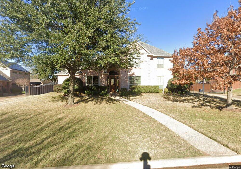
1214 Kings Brook Dr Southlake, TX 76092
Estimated Value: $1,348,860 - $1,460,000
4
Beds
4
Baths
4,075
Sq Ft
$348/Sq Ft
Est. Value
About This Home
This home is located at 1214 Kings Brook Dr, Southlake, TX 76092 and is currently estimated at $1,417,715, approximately $347 per square foot. 1214 Kings Brook Dr is a home located in Tarrant County with nearby schools including Old Union Elementary School, Eubanks Intermediate School, and George Dawson Middle School.
Ownership History
Date
Name
Owned For
Owner Type
Purchase Details
Closed on
May 20, 2002
Sold by
Weber Ronald J and Weber Pyong Ye
Bought by
Krauss Andrew and Mcdermott Theodore
Current Estimated Value
Home Financials for this Owner
Home Financials are based on the most recent Mortgage that was taken out on this home.
Original Mortgage
$291,900
Outstanding Balance
$111,839
Interest Rate
5.62%
Estimated Equity
$1,305,876
Purchase Details
Closed on
Jun 16, 1998
Sold by
Lahr Sharon A Hacker and Lahr Craig
Bought by
Weber Ronald J and Weber Pyong Ye
Home Financials for this Owner
Home Financials are based on the most recent Mortgage that was taken out on this home.
Original Mortgage
$263,350
Interest Rate
7.21%
Purchase Details
Closed on
Jun 12, 1996
Sold by
Murchison Properties Inc
Bought by
Hacker Sharon A
Home Financials for this Owner
Home Financials are based on the most recent Mortgage that was taken out on this home.
Original Mortgage
$130,000
Interest Rate
5.87%
Create a Home Valuation Report for This Property
The Home Valuation Report is an in-depth analysis detailing your home's value as well as a comparison with similar homes in the area
Home Values in the Area
Average Home Value in this Area
Purchase History
| Date | Buyer | Sale Price | Title Company |
|---|---|---|---|
| Krauss Andrew | -- | Alamo Title Company | |
| Weber Ronald J | -- | Safeco Land Title | |
| Hacker Sharon A | -- | American Title Company |
Source: Public Records
Mortgage History
| Date | Status | Borrower | Loan Amount |
|---|---|---|---|
| Open | Krauss Andrew | $291,900 | |
| Previous Owner | Weber Ronald J | $263,350 | |
| Previous Owner | Hacker Sharon A | $130,000 |
Source: Public Records
Tax History Compared to Growth
Tax History
| Year | Tax Paid | Tax Assessment Tax Assessment Total Assessment is a certain percentage of the fair market value that is determined by local assessors to be the total taxable value of land and additions on the property. | Land | Improvement |
|---|---|---|---|---|
| 2025 | $12,165 | $1,066,000 | $366,075 | $699,925 |
| 2024 | $12,165 | $1,175,000 | $366,075 | $808,925 |
| 2023 | $12,329 | $1,206,675 | $366,075 | $840,600 |
| 2022 | $17,112 | $913,311 | $244,050 | $669,261 |
| 2021 | $16,440 | $758,577 | $244,050 | $514,527 |
| 2020 | $15,068 | $655,512 | $219,645 | $435,867 |
| 2019 | $17,193 | $710,000 | $150,000 | $560,000 |
| 2018 | $14,814 | $650,000 | $150,000 | $500,000 |
| 2017 | $15,596 | $630,000 | $150,000 | $480,000 |
| 2016 | $14,178 | $638,592 | $150,000 | $488,592 |
| 2015 | $12,567 | $520,000 | $80,000 | $440,000 |
| 2014 | $12,567 | $563,800 | $80,000 | $483,800 |
Source: Public Records
Map
Nearby Homes
- 1304 Kings Brook Ct
- 702 Sussex Ct
- 223 Westwood Dr
- 1012 Cool River Dr
- 1032 Rosavine Dr
- 1028 Rosavine Dr
- 1017 Rosavine Dr
- 1004 Rosavine Dr
- 1020 Rosavine Dr
- 1012 Rosavine Dr
- 1024 Rosavine Dr
- 1005 Rosavine Dr
- 1016 Rosavine Dr
- 1008 Rosavine Dr
- 1577 Main St
- 1532 Main St
- 1591 Main St
- 350 Central Ave Unit 202
- 350 Central Ave Unit 503
- 350 Central Ave Unit 201
- 1216 Kings Brook Dr
- 1212 Kings Brook Dr
- 1221 Forest Hills Dr
- 1301 Forest Hills Ct
- 1218 Kings Brook Dr
- 1219 Forest Hills Dr
- 1213 Kings Brook Dr
- 1210 Kings Brook Dr
- 1303 Forest Hills Ct
- 1215 Kings Brook Dr
- 1211 Kings Brook Dr
- 1217 Kings Brook Dr
- 1217 Forest Hills Dr
- 1300 Kings Brook Ct
- 1305 Forest Hills Ct
- 1209 Kings Brook Dr
- 1300 Forest Hills Ct
- 1301 Kings Brook Ct
- 1205 Kings Brook Dr
- 500 Morningside Dr