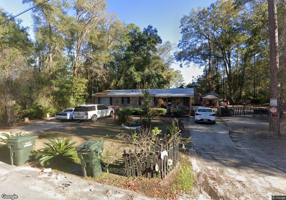
1214 Orleander Dr Bainbridge, GA 39817
Estimated Value: $59,000 - $170,000
--
Bed
1
Bath
1,200
Sq Ft
$81/Sq Ft
Est. Value
About This Home
This home is located at 1214 Orleander Dr, Bainbridge, GA 39817 and is currently estimated at $96,667, approximately $80 per square foot. 1214 Orleander Dr is a home with nearby schools including Bainbridge High School and Grace Christian Academy.
Ownership History
Date
Name
Owned For
Owner Type
Purchase Details
Closed on
Aug 12, 2020
Sold by
Giddens Ryan E
Bought by
Rawls Stephen J
Current Estimated Value
Purchase Details
Closed on
May 11, 2011
Sold by
Springfield Financial Services Inc
Bought by
Giddens Ryan E
Home Financials for this Owner
Home Financials are based on the most recent Mortgage that was taken out on this home.
Original Mortgage
$29,813
Interest Rate
4.88%
Mortgage Type
New Conventional
Purchase Details
Closed on
Jan 4, 2011
Sold by
Gaines Emma Lou
Bought by
American General Financial Services Inc
Create a Home Valuation Report for This Property
The Home Valuation Report is an in-depth analysis detailing your home's value as well as a comparison with similar homes in the area
Home Values in the Area
Average Home Value in this Area
Purchase History
| Date | Buyer | Sale Price | Title Company |
|---|---|---|---|
| Rawls Stephen J | $35,000 | -- | |
| Giddens Ryan E | $20,000 | -- | |
| American General Financial Services Inc | $39,900 | -- |
Source: Public Records
Mortgage History
| Date | Status | Borrower | Loan Amount |
|---|---|---|---|
| Previous Owner | Giddens Ryan E | $29,813 |
Source: Public Records
Tax History Compared to Growth
Tax History
| Year | Tax Paid | Tax Assessment Tax Assessment Total Assessment is a certain percentage of the fair market value that is determined by local assessors to be the total taxable value of land and additions on the property. | Land | Improvement |
|---|---|---|---|---|
| 2024 | $824 | $26,057 | $1,500 | $24,557 |
| 2023 | $804 | $26,057 | $1,500 | $24,557 |
| 2022 | $804 | $26,057 | $1,500 | $24,557 |
| 2021 | $770 | $24,311 | $1,500 | $22,811 |
| 2020 | $757 | $22,620 | $1,500 | $21,120 |
| 2019 | $742 | $21,348 | $1,500 | $19,848 |
| 2018 | $733 | $21,348 | $1,500 | $19,848 |
| 2017 | $660 | $18,888 | $1,500 | $17,388 |
| 2016 | $660 | $18,888 | $1,500 | $17,388 |
| 2015 | $679 | $18,888 | $1,500 | $17,388 |
| 2014 | $629 | $18,888 | $1,500 | $17,388 |
| 2013 | -- | $18,888 | $1,500 | $17,388 |
Source: Public Records
Map
Nearby Homes
- 927 5th Ave
- 836 Cooper St
- 705 N Lamar St
- 000 E River Rd
- 411 Independent St
- 502 Planter St
- 1503 Smart St
- 1302 Majestic Ave
- Lot 7 Easy Dr
- 1020 E Water St
- 435 E Broughton St
- 1606 Hemlock St
- 1204 E Water St
- 302 E Water St
- 1602 Belcher Ln
- 418 E Broughton St
- Dell Rd
- 640 E Shotwell St
- 632 E Shotwell St
- 423 E Shotwell St
- 1217 Oleander Dr
- 1219 Oleander Dr
- 1207 Oleander Dr
- 807 Oak Circle Dr
- 1223 Oleander Dr
- 1205 Oleander Dr
- 806 Oak Circle Dr
- 1232 Oleander Dr
- 1225 Oak Circle Dr
- 812 Oak Circle Dr
- 1206 Oleander Dr
- 814 Oak Circle Dr
- 816 Oak Circle Dr
- 1227 Oak Circle Dr
- 1202 Oleander Dr
- 816 Mulberry St
- 813 Maple Ave
- 1234 Conger Dr
- 817 Maple Ave
- 809 Maple Ave