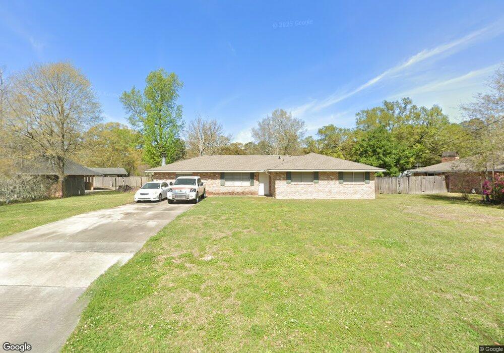
12145 Gebhart Dr Baton Rouge, LA 70816
Broadmoor/Sherwood NeighborhoodEstimated Value: $206,000 - $229,000
4
Beds
2
Baths
1,986
Sq Ft
$110/Sq Ft
Est. Value
About This Home
This home is located at 12145 Gebhart Dr, Baton Rouge, LA 70816 and is currently estimated at $218,163, approximately $109 per square foot. 12145 Gebhart Dr is a home located in East Baton Rouge Parish with nearby schools including Twin Oaks Elementary School, Southeast Middle School, and Broadmoor Senior High School.
Ownership History
Date
Name
Owned For
Owner Type
Purchase Details
Closed on
Oct 27, 1999
Sold by
Henderson Edward T
Bought by
Collins Randolph A and Collins Joycelyn D
Current Estimated Value
Home Financials for this Owner
Home Financials are based on the most recent Mortgage that was taken out on this home.
Original Mortgage
$99,080
Outstanding Balance
$30,479
Interest Rate
7.85%
Mortgage Type
FHA
Estimated Equity
$187,684
Purchase Details
Closed on
Apr 9, 1999
Sold by
Caraccioli Jody M and Montrose Joann O
Bought by
Henderson Edward Tyrone
Create a Home Valuation Report for This Property
The Home Valuation Report is an in-depth analysis detailing your home's value as well as a comparison with similar homes in the area
Home Values in the Area
Average Home Value in this Area
Purchase History
| Date | Buyer | Sale Price | Title Company |
|---|---|---|---|
| Collins Randolph A | $99,900 | -- | |
| Henderson Edward Tyrone | $76,500 | -- |
Source: Public Records
Mortgage History
| Date | Status | Borrower | Loan Amount |
|---|---|---|---|
| Open | Collins Randolph A | $99,080 |
Source: Public Records
Tax History Compared to Growth
Tax History
| Year | Tax Paid | Tax Assessment Tax Assessment Total Assessment is a certain percentage of the fair market value that is determined by local assessors to be the total taxable value of land and additions on the property. | Land | Improvement |
|---|---|---|---|---|
| 2024 | $1,031 | $18,041 | $1,200 | $16,841 |
| 2023 | $1,031 | $16,140 | $1,200 | $14,940 |
| 2022 | $1,927 | $16,140 | $1,200 | $14,940 |
| 2021 | $1,883 | $16,140 | $1,200 | $14,940 |
| 2020 | $1,907 | $16,140 | $1,200 | $14,940 |
| 2019 | $1,760 | $14,250 | $1,200 | $13,050 |
| 2018 | $1,739 | $14,250 | $1,200 | $13,050 |
| 2017 | $1,739 | $14,250 | $1,200 | $13,050 |
| 2016 | $357 | $9,683 | $1,200 | $8,483 |
| 2015 | $903 | $14,250 | $1,200 | $13,050 |
| 2014 | $900 | $14,250 | $1,200 | $13,050 |
| 2013 | -- | $14,250 | $1,200 | $13,050 |
Source: Public Records
Map
Nearby Homes
- 12023 Elva Dr
- 1765 Boulevard de Province Unit B
- 1769 Boulevard de Province Unit E
- 1763 Boulevard de Province Unit C
- 1763 Boulevard de Province Unit D
- 1781 Boulevard de Province Unit D
- 1793 Boulevard de Province Unit D
- 2331 Torrey Pine Dr
- 12500 Old Hammond Hwy Unit M2
- 0000 Boulevard de Province
- 12474 Fairhope Way
- 12611 Old Hammond Hwy
- 14217 Stone Gate Dr
- 12645 Warwick Ave
- 13717 Stone Gate Dr
- 13645 Stone Gate Dr
- 1810 W Fairview Dr
- 1715 Foxton Ct
- 1706 Foxton Ct
- 12416 Astolat Ave
- 12165 Gebhart Dr
- 12135 Gebhart Dr
- 12136 Elva Dr
- 12124 Elva Dr
- 12225 Gebhart Dr
- 12150 Elva Dr
- 12142 Gebhart Dr
- 12130 Gebhart Dr
- 12125 Gebhart Dr
- 12178 Elva Dr
- 12152 Gebhart Dr
- 12235 Gebhart Dr
- 12120 Gebhart Dr
- 12162 Gebhart Dr
- 12192 Elva Dr
- 12224 Gebhart Dr
- 0 Elva Dr
- 12110 Gebhart Dr
- 12135 Elva Dr
- 12243 Gebhart Dr