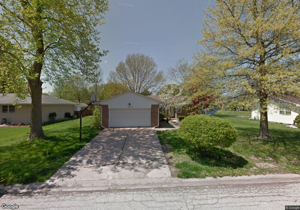
1215 5th St Pawnee, IL 62558
Estimated Value: $145,000 - $231,000
3
Beds
3
Baths
1,554
Sq Ft
$122/Sq Ft
Est. Value
About This Home
This home is located at 1215 5th St, Pawnee, IL 62558 and is currently estimated at $189,098, approximately $121 per square foot. 1215 5th St is a home located in Sangamon County with nearby schools including Pawnee Grade School and Pawnee Junior/Senior High School.
Ownership History
Date
Name
Owned For
Owner Type
Purchase Details
Closed on
Dec 11, 2008
Current Estimated Value
Purchase Details
Closed on
May 9, 2008
Purchase Details
Closed on
Jan 2, 2008
Purchase Details
Closed on
Jul 11, 2007
Purchase Details
Closed on
Jun 14, 2006
Purchase Details
Closed on
May 2, 1997
Create a Home Valuation Report for This Property
The Home Valuation Report is an in-depth analysis detailing your home's value as well as a comparison with similar homes in the area
Home Values in the Area
Average Home Value in this Area
Purchase History
| Date | Buyer | Sale Price | Title Company |
|---|---|---|---|
| -- | $63,800 | -- | |
| -- | $137,200 | -- | |
| -- | $75,000 | -- | |
| -- | -- | -- | |
| -- | -- | -- | |
| -- | $85,000 | -- |
Source: Public Records
Tax History
| Year | Tax Paid | Tax Assessment Tax Assessment Total Assessment is a certain percentage of the fair market value that is determined by local assessors to be the total taxable value of land and additions on the property. | Land | Improvement |
|---|---|---|---|---|
| 2024 | $2,231 | $37,334 | $7,401 | $29,933 |
| 2023 | $2,128 | $35,314 | $7,001 | $28,313 |
| 2022 | $2,038 | $33,479 | $6,637 | $26,842 |
| 2021 | $1,965 | $32,123 | $6,368 | $25,755 |
| 2020 | $1,950 | $31,730 | $6,290 | $25,440 |
| 2019 | $1,927 | $31,258 | $6,196 | $25,062 |
| 2018 | $1,857 | $30,621 | $6,070 | $24,551 |
| 2017 | $1,785 | $29,373 | $5,823 | $23,550 |
| 2016 | $2,196 | $28,474 | $5,645 | $22,829 |
| 2015 | $2,183 | $28,369 | $5,624 | $22,745 |
| 2014 | $2,108 | $28,046 | $5,560 | $22,486 |
| 2013 | $2,117 | $28,464 | $5,643 | $22,821 |
Source: Public Records
Map
Nearby Homes
- 1219 7th St Unit 1
- 622 6th St
- 115 2nd St Unit 1
- 107 3rd St Unit 1
- 27 Cahokia Dr
- 521 S Lincoln St
- 201 S 3rd St Unit 1
- 809 S 1st St
- ID29110400013 New City Rd
- 0 Old Indian Trail
- 8519 Cardinal Hill Rd
- 7355 New City Rd
- 8117 Tack Ln
- 8033 Wilson Terrace
- 2318 E Lake Shore Dr
- 5 Oakwood Dr
- 212 Gloucester Ct
- 33 Green Trail Dr Unit 1
- 412 Manor Hill Dr
- 3226 Brunk Dr Unit 1
- 1213 5th St Unit 1
- 1217 5th St Unit 1
- 1214 6th St Unit 1
- 1216 6th St Unit 1
- 1212 6th St Unit 1
- 1214 5th St Unit 1
- 1211 5th St Unit 1
- 1216 5th St Unit 1
- 1212 5th St Unit 1
- 1219 5th St Unit 1
- 1218 6th St Unit 1
- 1210 6th St Unit 1
- 1210 5th St Unit 1
- 1218 5th St Unit 1
- 1215 6th St Unit 1
- 1213 6th St
- 1217 6th St Unit 1
- 1209 5th St Unit 1
- 1221 5th St Unit 1
- 1215 Frisina St Unit 1
Your Personal Tour Guide
Ask me questions while you tour the home.