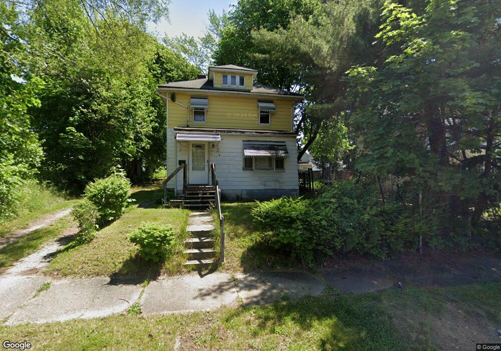
1215 Andrus St Akron, OH 44301
Downtown Akron NeighborhoodEstimated Value: $63,000 - $89,000
3
Beds
2
Baths
1,503
Sq Ft
$51/Sq Ft
Est. Value
About This Home
This home is located at 1215 Andrus St, Akron, OH 44301 and is currently estimated at $77,055, approximately $51 per square foot. 1215 Andrus St is a home located in Summit County with nearby schools including McEbright Elementary School, Kenmore Garfield Community Learning Center, and Main Preparatory Academy.
Ownership History
Date
Name
Owned For
Owner Type
Purchase Details
Closed on
May 9, 2019
Sold by
Richardson Jerrlean
Bought by
Tyson Garland Duane
Current Estimated Value
Purchase Details
Closed on
Dec 16, 2018
Sold by
Estate Of Michael L Richardson
Bought by
Richardson Jerrlean
Purchase Details
Closed on
Mar 5, 2013
Sold by
Tyson Willie R
Bought by
Richardson Michael L
Purchase Details
Closed on
Oct 1, 2010
Sold by
Franks John W
Bought by
Tyson Willie R
Purchase Details
Closed on
Apr 9, 2008
Sold by
Jackson Ida and Donofrio John A
Bought by
Franks John W
Create a Home Valuation Report for This Property
The Home Valuation Report is an in-depth analysis detailing your home's value as well as a comparison with similar homes in the area
Home Values in the Area
Average Home Value in this Area
Purchase History
| Date | Buyer | Sale Price | Title Company |
|---|---|---|---|
| Tyson Garland Duane | -- | None Available | |
| Richardson Jerrlean | -- | None Available | |
| Richardson Michael L | -- | None Available | |
| Tyson Willie R | $12,500 | None Available | |
| Franks John W | $6,865 | None Available |
Source: Public Records
Tax History Compared to Growth
Tax History
| Year | Tax Paid | Tax Assessment Tax Assessment Total Assessment is a certain percentage of the fair market value that is determined by local assessors to be the total taxable value of land and additions on the property. | Land | Improvement |
|---|---|---|---|---|
| 2025 | $712 | $12,079 | $4,218 | $7,861 |
| 2024 | $712 | $12,079 | $4,218 | $7,861 |
| 2023 | $712 | $12,079 | $4,218 | $7,861 |
| 2022 | $755 | $10,151 | $3,546 | $6,605 |
| 2021 | $756 | $10,151 | $3,546 | $6,605 |
| 2020 | $745 | $10,160 | $3,550 | $6,610 |
| 2019 | $1,186 | $15,050 | $4,660 | $10,390 |
| 2018 | $95 | $15,050 | $4,660 | $10,390 |
| 2017 | $95 | $15,050 | $4,660 | $10,390 |
| 2016 | $95 | $15,290 | $4,660 | $10,630 |
| 2015 | $95 | $15,290 | $4,660 | $10,630 |
| 2014 | $1,198 | $15,290 | $4,660 | $10,630 |
| 2013 | $679 | $17,260 | $4,660 | $12,600 |
Source: Public Records
Map
Nearby Homes