Estimated Value: $781,000 - $1,581,000
5
Beds
4
Baths
3,536
Sq Ft
$336/Sq Ft
Est. Value
About This Home
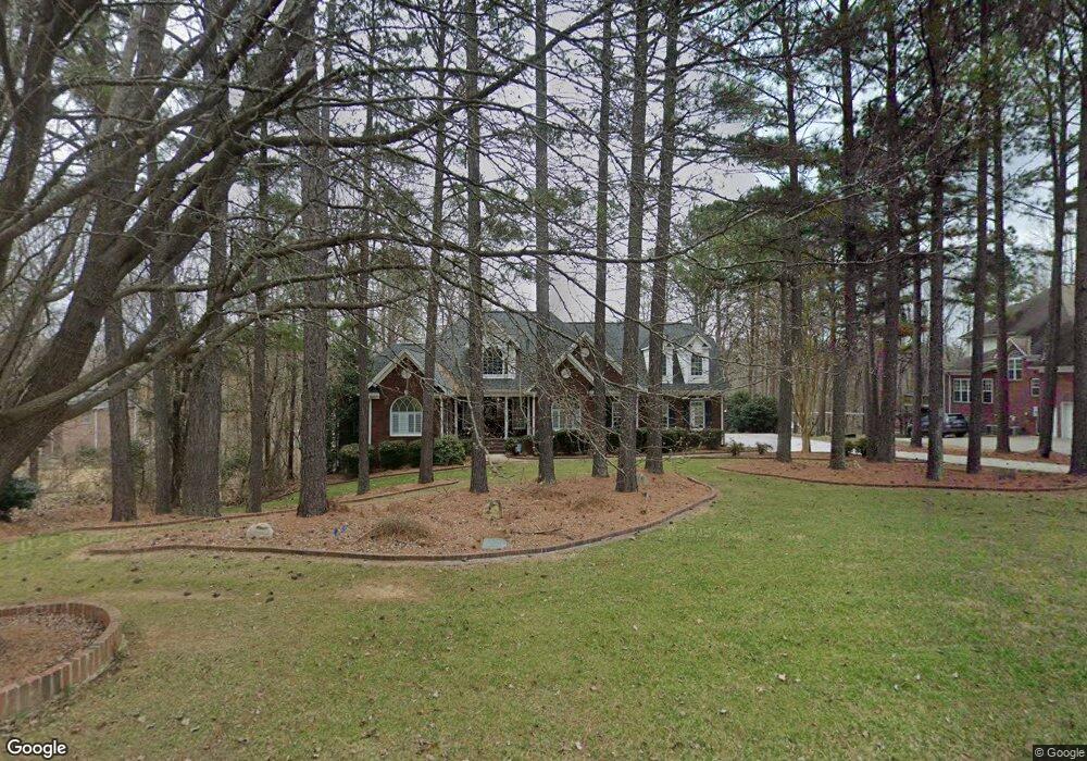
This home is located at 1215 Broadside Rd, York, SC 29745 and is currently estimated at $1,189,493, approximately $336 per square foot. 1215 Broadside Rd is a home located in York County with nearby schools including Bethel Elementary School, Oakridge Middle School, and Clover High School.
Ownership History
Date
Name
Owned For
Owner Type
Purchase Details
Closed on
May 15, 2009
Sold by
Armstrong Nancy D
Bought by
Lahaie Richard S and Lahaie Brenda L
Current Estimated Value
Home Financials for this Owner
Home Financials are based on the most recent Mortgage that was taken out on this home.
Original Mortgage
$143,000
Outstanding Balance
$113,409
Interest Rate
4.81%
Mortgage Type
Credit Line Revolving
Estimated Equity
$1,076,085
Purchase Details
Closed on
Aug 20, 2004
Sold by
Karnap Homes Inc
Bought by
Armstrong John J and Armstrong Nancy D
Purchase Details
Closed on
Apr 8, 2003
Sold by
Daves & Montgomery Enterprises Llc
Bought by
Karnap Homes Inc
Create a Home Valuation Report for This Property
The Home Valuation Report is an in-depth analysis detailing your home's value as well as a comparison with similar homes in the area
Home Values in the Area
Average Home Value in this Area
Purchase History
| Date | Buyer | Sale Price | Title Company |
|---|---|---|---|
| Lahaie Richard S | $700,000 | -- | |
| Armstrong John J | $585,000 | -- | |
| Karnap Homes Inc | $209,900 | -- |
Source: Public Records
Mortgage History
| Date | Status | Borrower | Loan Amount |
|---|---|---|---|
| Open | Lahaie Richard S | $143,000 | |
| Open | Lahaie Richard S | $417,000 |
Source: Public Records
Tax History
| Year | Tax Paid | Tax Assessment Tax Assessment Total Assessment is a certain percentage of the fair market value that is determined by local assessors to be the total taxable value of land and additions on the property. | Land | Improvement |
|---|---|---|---|---|
| 2025 | $5,414 | $39,546 | $14,121 | $25,425 |
| 2024 | $3,546 | $25,092 | $9,466 | $15,626 |
| 2023 | $3,636 | $25,092 | $9,466 | $15,626 |
| 2022 | $2,996 | $25,092 | $9,466 | $15,626 |
| 2021 | -- | $25,092 | $9,466 | $15,626 |
| 2020 | $2,841 | $25,092 | $0 | $0 |
| 2019 | $2,695 | $21,820 | $0 | $0 |
| 2018 | $2,460 | $21,820 | $0 | $0 |
| 2017 | $2,291 | $19,820 | $0 | $0 |
| 2016 | $2,158 | $19,820 | $0 | $0 |
| 2014 | $2,752 | $19,220 | $9,000 | $10,220 |
| 2013 | $2,752 | $24,140 | $11,000 | $13,140 |
Source: Public Records
Map
Nearby Homes
- 1203 Broadside Rd
- 1220 Broadside Rd
- 2409 Valelake Rd
- 5369 Concord Rd
- 2354 Valelake Rd
- 5283 Johnsons Barn Rd
- 4238 Brushy Knoll
- 5312 Johnsons Barn Rd
- 553 Mahagony Rd
- 570 Mahagony Rd
- 577 Mahagony Rd
- 563 Mahagony Rd
- 2219 Keppel Ct
- 1256 Aft Ln
- 1224 Aft Ln
- 291 Supernova Dr
- 937 Canopy Falls Ln
- 2122 Skyhawk Dr
- 2123 Skyhawk Dr
- 2 Pinnacle Way Unit Nottingham
- 1211 Broadside Rd
- 1219 Broadside Rd
- 1207 Broadside Rd
- 1212 Broadside Rd
- 1216 Broadside Rd
- 1216 Broadside Rd Unit 17
- 1223 Broadside Rd
- 1208 Broadside Rd
- 1227 Broadside Rd
- 2737 Windswept Cove
- 2731 Windswept Cove
- 2753 Windswept Cove
- 1224 Broadside Rd Unit 19
- 1224 Broadside Rd
- 2725 Windswept Cove
- 2777 Windswept Cove
- 1204 Broadside Rd
- 2761 Windswept Cove
- 2745 Windswept Cove
- 2801 Windswept Cove
Your Personal Tour Guide
Ask me questions while you tour the home.