
Seller's Agent in 2025
Kerri Garvey
Baird Warner
(708) 697-5900
1 in this area
3 Total Sales


Estimated Value: $351,000 - $355,021
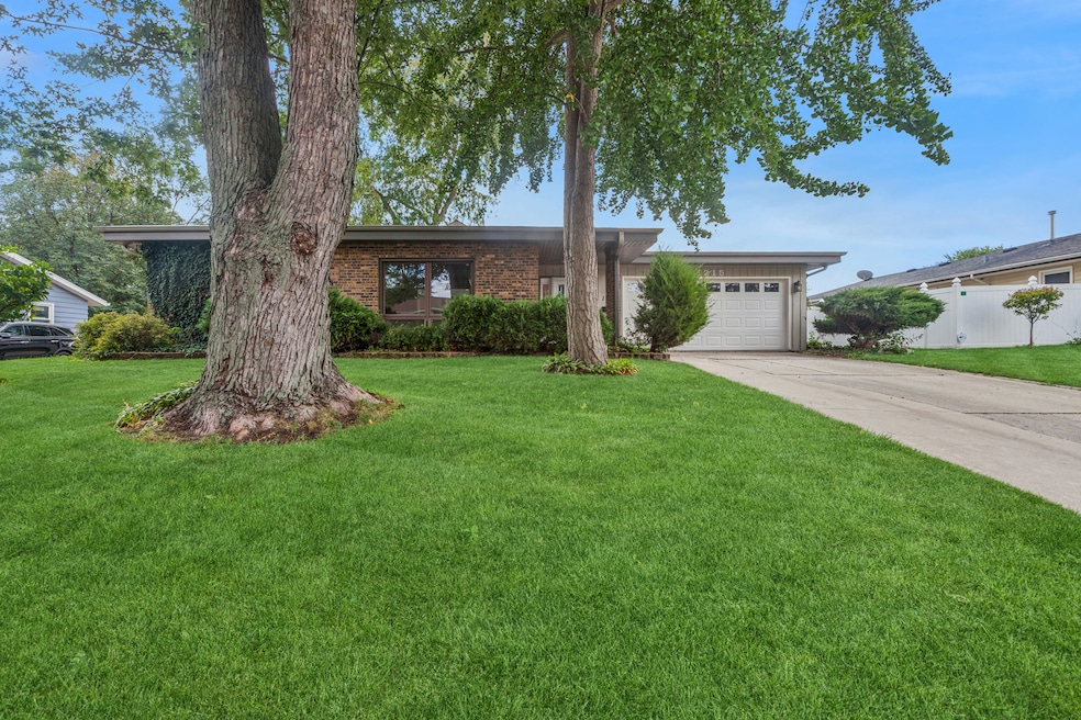
Welcome to your new home! This unique, move-in ready 3-bedroom, 2.5-bath brick ranch is nestled in a well-established Aurora neighborhood surrounded by mature trees and offers fantastic curb appeal. Enter to discover a bright, open layout centered around a stunning atrium that fills the home with natural light. The interior has been thoughtfully updated with fresh paint, new flooring throughout most of the home, and modern touches in all three bathrooms. There's plenty of living space, along with a large kitchen featuring custom cabinetry, a bay window, and an eat-in breakfast nook, perfect for everyday living. Additional highlights include a beautiful back patio that's an entertainer's dream, a two-car garage, generous front yard, and newer windows throughout the home. Conveniently located just minutes from I-88, Metra, the Illinois Prairie Path, schools, parks, and a popular outlet shopping mall, this home combines comfort, one-of-a-kind style, and convenience. Don't miss your chance to make it yours-schedule your showing today! ***ASKING FOR HIGHEST AND BEST OFFERS BY 2:00 PM, MONDAY, OCTOBER 13 ***
Last Agent to Sell the Property
Baird & Warner License #475215292 Listed on: 10/01/2025
| Date | Buyer | Sale Price | Title Company |
|---|---|---|---|
| Barrera Mario | $354,500 | First American Title | |
| Atkin Eugene L | $235,000 | First American Title | |
| Gonzalez Ricardo | $149,000 | Ticor Title Insurance Compan | |
| Ford Ronald | $119,500 | Law Title Insurance Co Inc |
| Date | Status | Borrower | Loan Amount |
|---|---|---|---|
| Open | Barrera Mario | $319,050 | |
| Previous Owner | Atkin Eugene L | $211,500 | |
| Previous Owner | Gonzalez Ricardo | $115,000 | |
| Previous Owner | Ford Ronald | $107,350 |
| Date | Event | Price | List to Sale | Price per Sq Ft |
|---|---|---|---|---|
| 11/13/2025 11/13/25 | Sold | $354,500 | 0.0% | $169 / Sq Ft |
| 10/15/2025 10/15/25 | Pending | -- | -- | -- |
| 10/01/2025 10/01/25 | For Sale | $354,500 | -- | $169 / Sq Ft |
| Year | Tax Paid | Tax Assessment Tax Assessment Total Assessment is a certain percentage of the fair market value that is determined by local assessors to be the total taxable value of land and additions on the property. | Land | Improvement |
|---|---|---|---|---|
| 2024 | $5,830 | $101,042 | $14,669 | $86,373 |
| 2023 | $5,551 | $90,281 | $13,107 | $77,174 |
| 2022 | $5,423 | $82,373 | $11,959 | $70,414 |
| 2021 | $5,303 | $76,690 | $11,134 | $65,556 |
| 2020 | $5,009 | $71,234 | $10,342 | $60,892 |
| 2019 | $4,846 | $66,000 | $9,582 | $56,418 |
| 2018 | $4,585 | $61,357 | $8,863 | $52,494 |
| 2017 | $4,673 | $58,653 | $8,166 | $50,487 |
| 2016 | $4,915 | $57,704 | $8,858 | $48,846 |
| 2015 | -- | $50,551 | $7,617 | $42,934 |
| 2014 | -- | $47,287 | $7,326 | $39,961 |
| 2013 | -- | $46,613 | $7,221 | $39,392 |
Seller's Agent in 2025
Kerri Garvey
Baird Warner
(708) 697-5900
1 in this area
3 Total Sales
C
Buyer's Agent in 2025
Carlos Olvera
Eden Properties Real Estate Group
(888) 849-9599
2 in this area
62 Total Sales
Source: Midwest Real Estate Data (MRED)
MLS Number: 12473150
APN: 15-11-427-002
Disclaimer: Certain information contained herein is derived from information provided by parties other than Homes.com. All information provided is deemed reliable, but is not guaranteed to be accurate and should be independently verified.
![]() Based on information submitted to the MLS GRID. All data is obtained from various sources and may not have been verified by broker or MLS GRID. Supplied Open House Information is subject to change without notice. All information should be independently reviewed and verified for accuracy. Properties may or may not be listed by the office/agent presenting the information. Some IDX listings have been excluded from this website.
Based on information submitted to the MLS GRID. All data is obtained from various sources and may not have been verified by broker or MLS GRID. Supplied Open House Information is subject to change without notice. All information should be independently reviewed and verified for accuracy. Properties may or may not be listed by the office/agent presenting the information. Some IDX listings have been excluded from this website.
Based on information submitted to the MLS GRID
Ask me questions while you tour the home.