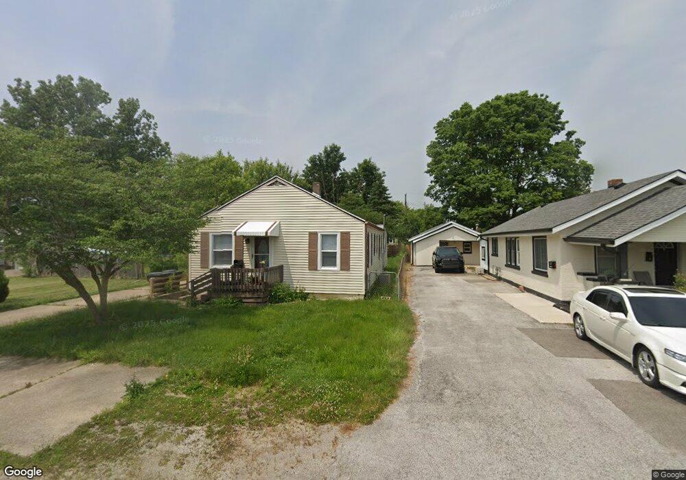
1215 Lennox St Anderson, IN 46012
Estimated Value: $126,127 - $167,000
3
Beds
1
Bath
1,200
Sq Ft
$125/Sq Ft
Est. Value
About This Home
This home is located at 1215 Lennox St, Anderson, IN 46012 and is currently estimated at $150,032, approximately $125 per square foot. 1215 Lennox St is a home located in Madison County with nearby schools including Tenth Street Elementary School, Highland Middle School, and Anderson High School.
Ownership History
Date
Name
Owned For
Owner Type
Purchase Details
Closed on
May 4, 2016
Sold by
Us Bank Na
Bought by
Black Pearl Funding Llc
Current Estimated Value
Purchase Details
Closed on
Dec 9, 2015
Sold by
Madison County Sheriff
Bought by
Us Bank Na
Purchase Details
Closed on
Feb 25, 2005
Sold by
Baker Erika V and Baker Thomas S
Bought by
Russell Terry A
Create a Home Valuation Report for This Property
The Home Valuation Report is an in-depth analysis detailing your home's value as well as a comparison with similar homes in the area
Home Values in the Area
Average Home Value in this Area
Purchase History
| Date | Buyer | Sale Price | Title Company |
|---|---|---|---|
| Black Pearl Funding Llc | $21,599 | -- | |
| Us Bank Na | -- | -- | |
| Russell Terry A | -- | -- |
Source: Public Records
Tax History Compared to Growth
Tax History
| Year | Tax Paid | Tax Assessment Tax Assessment Total Assessment is a certain percentage of the fair market value that is determined by local assessors to be the total taxable value of land and additions on the property. | Land | Improvement |
|---|---|---|---|---|
| 2025 | $1,758 | $79,100 | $8,100 | $71,000 |
| 2024 | $1,758 | $79,100 | $8,100 | $71,000 |
| 2023 | $1,615 | $72,200 | $7,700 | $64,500 |
| 2022 | $1,629 | $72,800 | $7,600 | $65,200 |
| 2021 | $1,501 | $66,700 | $7,500 | $59,200 |
| 2020 | $1,410 | $62,400 | $7,200 | $55,200 |
| 2019 | $1,410 | $60,800 | $7,200 | $53,600 |
| 2018 | $1,253 | $54,300 | $7,200 | $47,100 |
| 2017 | $1,070 | $53,500 | $7,200 | $46,300 |
| 2016 | $1,052 | $52,600 | $7,200 | $45,400 |
| 2014 | $455 | $52,000 | $7,200 | $44,800 |
| 2013 | $455 | $52,000 | $7,200 | $44,800 |
Source: Public Records
Map
Nearby Homes
- 1223 Fairfax St
- 1520 Chesterfield Dr
- 1006 Evergreen Ct
- 2701 E 8th St
- 630 Chester St
- 916 Alhambra Dr
- 1921 E 10th St
- 2509 Fowler St
- 713 Ellenhurst Dr
- 2313 E 5th St
- 1803 E 10th St
- 2526 E 5th St
- 1919 S Scatterfield Rd
- 2208 E 5th St
- 1708 C St
- 2405 E 3rd St
- 1639 E 18th St
- 1606 E 8th St
- 1625 B St Unit 47
- 1625 B St Unit 26
- 1213 Lennox St
- 1211 Lennox St
- 1223 Lennox St
- 2425 Hillcrest Dr
- 1216 Chester St
- 1210 Chester St
- 1218 Chester St
- 1227 Lennox St
- 1222 Chester St
- 1206 Chester St
- 2512 Pamela Ct
- 2512 Pamela Ct Unit 11A
- 2506 Pamela Ct
- 2510 Pamela Ct
- 2510 Pamela Ct Unit 11/B
- 1306 Chester St
- 1127 Lennox St
- 2508 Pamela Ct Unit 12A
- 2502 Sassafras Dr
- 2502 Sassafras Dr Unit 13A