Estimated Value: $195,000 - $265,000
3
Beds
1
Bath
1,332
Sq Ft
$182/Sq Ft
Est. Value
About This Home
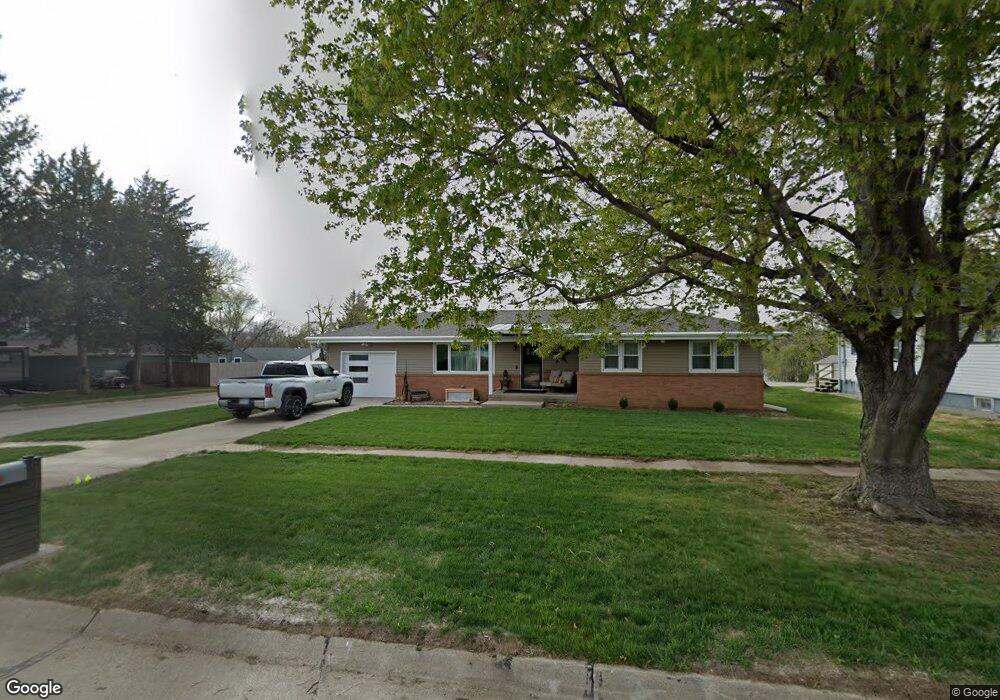
This home is located at 1215 N Locust St, Wahoo, NE 68066 and is currently estimated at $242,181, approximately $181 per square foot. 1215 N Locust St is a home located in Saunders County with nearby schools including Wahoo Elementary School, Wahoo Middle School, and Wahoo High School.
Ownership History
Date
Name
Owned For
Owner Type
Purchase Details
Closed on
Jul 30, 2020
Sold by
Gittins Jody and Gittins Rex
Bought by
Dailey Mary C
Current Estimated Value
Create a Home Valuation Report for This Property
The Home Valuation Report is an in-depth analysis detailing your home's value as well as a comparison with similar homes in the area
Home Values in the Area
Average Home Value in this Area
Purchase History
| Date | Buyer | Sale Price | Title Company |
|---|---|---|---|
| Dailey Mary C | $76,000 | Homeservices Title Wahoo |
Source: Public Records
Tax History Compared to Growth
Tax History
| Year | Tax Paid | Tax Assessment Tax Assessment Total Assessment is a certain percentage of the fair market value that is determined by local assessors to be the total taxable value of land and additions on the property. | Land | Improvement |
|---|---|---|---|---|
| 2024 | $2,551 | $188,567 | $26,850 | $161,717 |
| 2023 | $3,198 | $182,755 | $26,850 | $155,905 |
| 2022 | $3,059 | $163,107 | $26,850 | $136,257 |
| 2021 | $2,288 | $118,652 | $26,850 | $91,802 |
| 2020 | $2,245 | $115,663 | $26,850 | $88,813 |
| 2019 | $2,228 | $112,247 | $26,850 | $85,397 |
| 2018 | $2,296 | $110,780 | $26,850 | $83,930 |
| 2017 | $23 | $110,780 | $26,850 | $83,930 |
| 2016 | $2,007 | $95,720 | $26,760 | $68,960 |
| 2015 | $2,022 | $95,720 | $26,760 | $68,960 |
| 2014 | $2,058 | $95,720 | $26,760 | $68,960 |
| 2012 | $2,178 | $95,720 | $26,760 | $68,960 |
Source: Public Records
Map
Nearby Homes
- 820 W 15th St
- 651 W 16th St
- 1039 N Laurel St
- 720 W 10th St
- 1365 N Chestnut St
- 565 W 10th St
- 2689 N Oak St
- 878 W 8th St
- 1561 N Linden St
- 122 E 10th St
- 1775 17th Avenue Rd Unit 2.36 Acres
- 758 W Park Cir
- 453 W 7th St
- 1672 N Linden St
- 2186 N Linden St
- 2228 N Linden St
- 428 E 14th St
- 453 W 4th St
- 327 E 7th St
- 670 W 24th Cir
- 1227 N Locust St
- 1175 N Locust St
- 1178 N Locust St
- 1159 N Locust St
- 1269 N Locust St
- 1170 N Locust St
- 555 W 12th St
- 1162 N Locust St
- 1145 N Locust St
- 1154 N Locust St
- 2300 N Locust St
- 13th Walnut St
- 1146 N Locust St
- 1335 N Locust St
- 1145 N Laurel St
- 1209 N Sycamore St
- 1138 N Locust St
- 1127 N Locust St
- 1191 N Sycamore St
- 1239 N Sycamore St