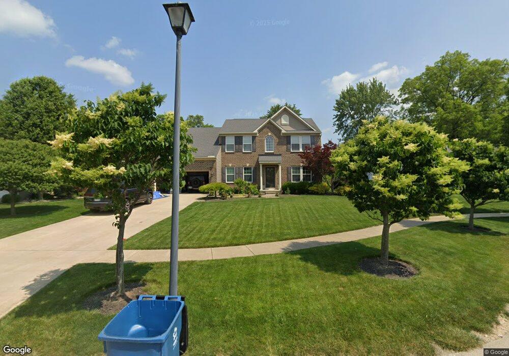
1216 Meadowbrook Ct Amherst, OH 44001
Estimated Value: $395,000 - $470,000
4
Beds
3
Baths
2,800
Sq Ft
$152/Sq Ft
Est. Value
About This Home
This home is located at 1216 Meadowbrook Ct, Amherst, OH 44001 and is currently estimated at $424,760, approximately $151 per square foot. 1216 Meadowbrook Ct is a home with nearby schools including Powers Elementary School, Walter G. Nord Middle School, and Amherst Junior High School.
Ownership History
Date
Name
Owned For
Owner Type
Purchase Details
Closed on
Jul 9, 2010
Sold by
Nvr Inc
Bought by
Hylton Adam M and Hylton Amber E
Current Estimated Value
Home Financials for this Owner
Home Financials are based on the most recent Mortgage that was taken out on this home.
Original Mortgage
$222,087
Outstanding Balance
$144,975
Interest Rate
4.37%
Mortgage Type
FHA
Estimated Equity
$279,785
Purchase Details
Closed on
Jun 3, 2010
Sold by
Braeburn Amherst Llc
Bought by
Nvr Inc and Ryan Homes
Home Financials for this Owner
Home Financials are based on the most recent Mortgage that was taken out on this home.
Original Mortgage
$222,087
Outstanding Balance
$144,975
Interest Rate
4.37%
Mortgage Type
FHA
Estimated Equity
$279,785
Create a Home Valuation Report for This Property
The Home Valuation Report is an in-depth analysis detailing your home's value as well as a comparison with similar homes in the area
Home Values in the Area
Average Home Value in this Area
Purchase History
| Date | Buyer | Sale Price | Title Company |
|---|---|---|---|
| Hylton Adam M | $225,100 | Nvr Title Agency Llc | |
| Nvr Inc | $35,000 | Nvr Title Agency Llc |
Source: Public Records
Mortgage History
| Date | Status | Borrower | Loan Amount |
|---|---|---|---|
| Open | Hylton Adam M | $222,087 |
Source: Public Records
Tax History Compared to Growth
Tax History
| Year | Tax Paid | Tax Assessment Tax Assessment Total Assessment is a certain percentage of the fair market value that is determined by local assessors to be the total taxable value of land and additions on the property. | Land | Improvement |
|---|---|---|---|---|
| 2024 | $4,966 | $122,983 | $26,828 | $96,156 |
| 2023 | $4,544 | $94,833 | $18,673 | $76,160 |
| 2022 | $4,356 | $94,833 | $18,673 | $76,160 |
| 2021 | $4,367 | $94,833 | $18,673 | $76,160 |
| 2020 | $4,795 | $92,430 | $18,200 | $74,230 |
| 2019 | $4,699 | $92,430 | $18,200 | $74,230 |
| 2018 | $4,563 | $92,430 | $18,200 | $74,230 |
| 2017 | $4,403 | $80,880 | $16,090 | $64,790 |
| 2016 | $4,439 | $80,880 | $16,090 | $64,790 |
| 2015 | $4,414 | $80,880 | $16,090 | $64,790 |
| 2014 | $4,629 | $84,430 | $16,800 | $67,630 |
| 2013 | $4,143 | $75,310 | $16,800 | $58,510 |
Source: Public Records
Map
Nearby Homes
- 0 Cooper Foster Park Rd Unit 5129838
- 3489 Coopers Trail
- 110 Habant Dr
- 1250 N Main St
- 1011 N Main St
- 357 Pebble Creek Ct
- 922 Sharondale Dr
- 117 Fall Lake Ln
- 0 Rosecliff Dr
- 4510 Weathervane Dr
- 4872 Leavitt Rd
- 4680 Boulder Ln
- 369 Pebble Creek Ct
- 707 Greenlawn Dr
- 3794 Freedom Place
- 3788 Freedom Place
- 3784 Freedom Place
- 3774 Freedom Place Unit A
- 3772 Freedom Place Unit B
- 3770 Freedom Place Unit C
- 1220 Meadowbrook Ct
- 1212 Meadowbrook Ct
- 1250 Beverly Dr
- 1224 Meadowbrook Ct
- 1215 Meadowbrook Ct
- 1208 Meadowbrook Ct
- 1223 Meadowbrook Ct
- 1219 Meadowbrook Ct
- 1255 Beverly Dr
- 1205 Meadowbrook Ct
- TBD Meadowbrook Ct
- 1250 Rear Land Dr
- 1260 Beverly Dr
- 1220 Meadowview Ln
- 1204 Meadowbrook Ct
- 1230 Meadowview Ln
- 1265 Beverly Dr
- 1210 Meadowview Ln
- 371 Killdeer Dr
- 353 Killdeer Dr