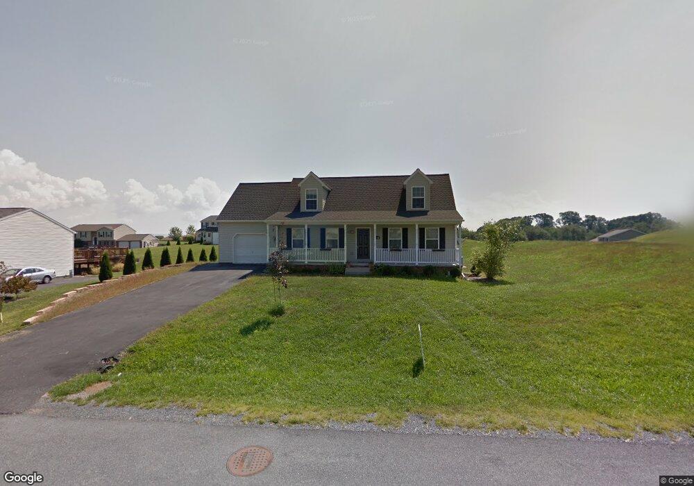
12168 Skyhawk Dr Waynesboro, PA 17268
Estimated Value: $203,432 - $363,000
4
Beds
2
Baths
1,734
Sq Ft
$179/Sq Ft
Est. Value
About This Home
This home is located at 12168 Skyhawk Dr, Waynesboro, PA 17268 and is currently estimated at $311,108, approximately $179 per square foot. 12168 Skyhawk Dr is a home located in Franklin County with nearby schools including Waynesboro Area Senior High School, St. Andrew Catholic School, and Noah's Ark Christian Child Care Center.
Ownership History
Date
Name
Owned For
Owner Type
Purchase Details
Closed on
Jul 23, 2013
Sold by
Sisson Sean T
Bought by
Le Page Norman J and Lepage Cheryl L
Current Estimated Value
Purchase Details
Closed on
Oct 31, 2008
Sold by
Albert Eugene S and Carbaugh Donovan C
Bought by
Sisson Sean T
Home Financials for this Owner
Home Financials are based on the most recent Mortgage that was taken out on this home.
Original Mortgage
$176,000
Interest Rate
6.08%
Mortgage Type
New Conventional
Create a Home Valuation Report for This Property
The Home Valuation Report is an in-depth analysis detailing your home's value as well as a comparison with similar homes in the area
Home Values in the Area
Average Home Value in this Area
Purchase History
| Date | Buyer | Sale Price | Title Company |
|---|---|---|---|
| Le Page Norman J | $175,000 | None Available | |
| Sisson Sean T | $220,000 | First American Title Insuran |
Source: Public Records
Mortgage History
| Date | Status | Borrower | Loan Amount |
|---|---|---|---|
| Previous Owner | Sisson Sean T | $176,000 |
Source: Public Records
Tax History Compared to Growth
Tax History
| Year | Tax Paid | Tax Assessment Tax Assessment Total Assessment is a certain percentage of the fair market value that is determined by local assessors to be the total taxable value of land and additions on the property. | Land | Improvement |
|---|---|---|---|---|
| 2025 | $3,843 | $25,020 | $4,160 | $20,860 |
| 2024 | $3,731 | $25,020 | $4,160 | $20,860 |
| 2023 | $3,621 | $25,020 | $4,160 | $20,860 |
| 2022 | $3,513 | $25,020 | $4,160 | $20,860 |
| 2021 | $3,413 | $25,020 | $4,160 | $20,860 |
| 2020 | $3,361 | $25,020 | $4,160 | $20,860 |
| 2019 | $2,739 | $24,910 | $4,160 | $20,750 |
| 2018 | $3,165 | $24,910 | $4,160 | $20,750 |
| 2017 | $3,097 | $24,910 | $4,160 | $20,750 |
| 2016 | $714 | $24,910 | $4,160 | $20,750 |
| 2015 | $665 | $24,910 | $4,160 | $20,750 |
| 2014 | $665 | $24,910 | $4,160 | $20,750 |
Source: Public Records
Map
Nearby Homes
- 4798 Gray Hawk Dr Unit 17
- 12152 Red Hawk Dr
- 5377 Harrier Way
- 5385 Harrier Way
- TBD Whippet Trail
- 12041 Koons Rd
- TBD Harrier Way
- 4594 Salem Church Rd
- 6287 Marsh Rd
- 6668 Marsh Rd
- 607 Chicory Spring Ct
- 462 Scott Ave Unit 4
- 417 Fairview Ave
- 217 Fairview Ave
- 105 Fairview Ave
- 0 Westview Ave
- 220 Cleveland Ave
- 511 Hamilton Ave
- 208 Hamilton Ave
- 12168 Sky Hawk Dr
- 12142 Sky Hawk Dr
- 4795 Gray Hawk Dr
- 12194 Skyhawk Dr
- 12194 Sky Hawk Dr
- 12145 Sky Hawk Dr
- 12171 Sky Hawk Dr
- 12145 Skyhawk Dr
- 12197 Sky Hawk Dr
- 12138 Sky Hawk Dr
- 4798 Gray Hawk Dr
- 4825 Gray Hawk Dr
- 12126 Sky Hawk Dr
- 12220 Sky Hawk Dr
- 4828 Gray Hawk Dr
- 12130 Skyhawk Dr
- 12125 Red Hawk Dr
- 12129 Sky Hawk Dr
- 4837 Gray Hawk Dr
- 12223 Sky Hawk Dr