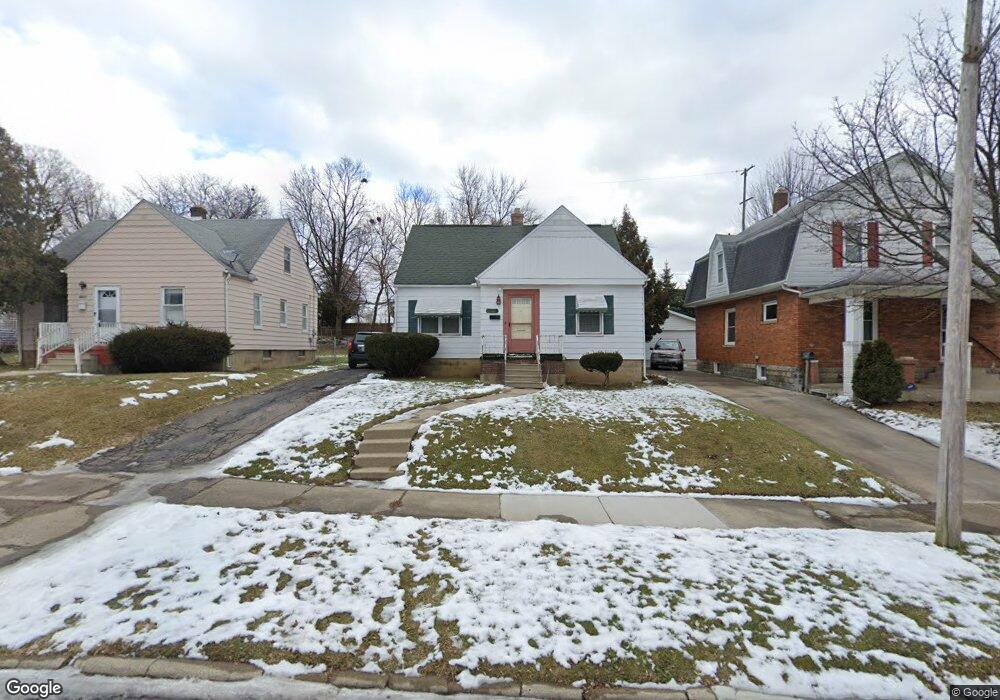
1217 Boston Ave Flint, MI 48503
Southwest Flint NeighborhoodEstimated Value: $83,220 - $88,000
3
Beds
1
Bath
1,278
Sq Ft
$67/Sq Ft
Est. Value
About This Home
This home is located at 1217 Boston Ave, Flint, MI 48503 and is currently estimated at $85,555, approximately $66 per square foot. 1217 Boston Ave is a home located in Genesee County with nearby schools including Eisenhower School, Flint Southwestern Classical Academy, and St John Vianney Catholic School.
Ownership History
Date
Name
Owned For
Owner Type
Purchase Details
Closed on
Apr 6, 2015
Sold by
The Genesee County Land Bank Authority
Bought by
Steve Samuel Pierre
Current Estimated Value
Purchase Details
Closed on
Dec 22, 2014
Sold by
Genesee County Treasurer
Bought by
Genesee County Land Bank
Purchase Details
Closed on
Jun 29, 2005
Sold by
Dunkley Richard T and Dunkley Mary
Bought by
Mullins Shelby
Create a Home Valuation Report for This Property
The Home Valuation Report is an in-depth analysis detailing your home's value as well as a comparison with similar homes in the area
Home Values in the Area
Average Home Value in this Area
Purchase History
| Date | Buyer | Sale Price | Title Company |
|---|---|---|---|
| Steve Samuel Pierre | $14,000 | None Available | |
| Genesee County Land Bank | -- | None Available | |
| Mullins Shelby | $83,000 | Metropolitan Title Company |
Source: Public Records
Mortgage History
| Date | Status | Borrower | Loan Amount |
|---|---|---|---|
| Closed | Steve Samuel Pierre | $0 |
Source: Public Records
Tax History
| Year | Tax Paid | Tax Assessment Tax Assessment Total Assessment is a certain percentage of the fair market value that is determined by local assessors to be the total taxable value of land and additions on the property. | Land | Improvement |
|---|---|---|---|---|
| 2025 | $1,846 | $33,500 | $0 | $0 |
| 2024 | $1,694 | $31,400 | $0 | $0 |
| 2023 | $1,643 | $25,400 | $0 | $0 |
| 2022 | $0 | $21,700 | $0 | $0 |
| 2021 | $1,674 | $20,700 | $0 | $0 |
| 2020 | $1,523 | $20,200 | $0 | $0 |
| 2019 | $1,476 | $18,800 | $0 | $0 |
| 2018 | $1,554 | $19,100 | $0 | $0 |
| 2017 | $1,523 | $0 | $0 | $0 |
| 2016 | $1,578 | $0 | $0 | $0 |
| 2015 | -- | $0 | $0 | $0 |
| 2014 | -- | $0 | $0 | $0 |
| 2012 | -- | $21,900 | $0 | $0 |
Source: Public Records
Map
Nearby Homes
- 1114 Christopher St
- 2112 Miller Rd
- 2124 Swayze St
- 1820 Chelsea Cir
- 2310 Gibson St
- 2410 Corunna Rd
- 2433 Brown St
- 2437 Zimmerman St
- 2509 Corunna Rd
- 2464 Gibson St
- 2537 Swayze St
- 607 Thayer St
- 2618 Brown St
- 2729 Chicago Blvd
- 2663 W Court St
- 2805 Reynolds St
- 932 Bradley Ave
- 1114 Clancy Ave
- 913 Davis St
- 612 Bradley Ave
- 1213 Boston Ave
- 1221 Boston Ave
- 1209 Boston Ave
- 1225 Boston Ave
- 1214 Pershing St
- 1222 Pershing St
- 1205 Boston Ave
- 1229 Boston Ave
- 1210 Pershing St
- 1208 Boston Ave
- 1228 Pershing St
- 1201 Boston Ave
- 1216 Boston Ave
- 1220 Boston Ave
- 1202 Pershing St
- 1224 Boston Ave
- 1212 Boston Ave
- 1228 Boston Ave
- 1202 Boston Ave
- 1914 Miller Rd
Your Personal Tour Guide
Ask me questions while you tour the home.