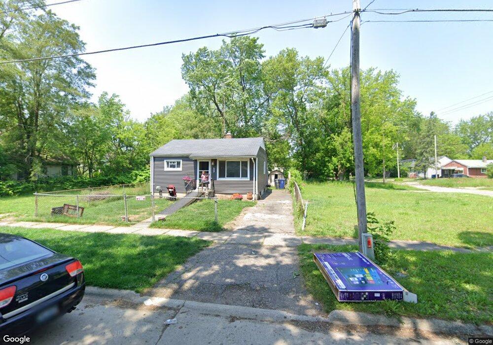
1217 Donaldson Blvd Flint, MI 48504
Ballenger Highway NeighborhoodEstimated Value: $31,501 - $162,000
2
Beds
1
Bath
679
Sq Ft
$119/Sq Ft
Est. Value
About This Home
This home is located at 1217 Donaldson Blvd, Flint, MI 48504 and is currently estimated at $80,500, approximately $118 per square foot. 1217 Donaldson Blvd is a home located in Genesee County with nearby schools including Durant-Tuuri-Mott Elementary School, Greater Heights Academy, and St. Paul Lutheran School.
Ownership History
Date
Name
Owned For
Owner Type
Purchase Details
Closed on
Dec 20, 2016
Sold by
Cherry Deborah L
Bought by
Genesee County Land Bank
Current Estimated Value
Purchase Details
Closed on
Apr 24, 2013
Sold by
Bolden Bobby
Bought by
Security Credit Union and Security Federal Credit Union
Purchase Details
Closed on
Oct 27, 2004
Sold by
Reid Jeffrey A
Bought by
Bolden Bobby
Create a Home Valuation Report for This Property
The Home Valuation Report is an in-depth analysis detailing your home's value as well as a comparison with similar homes in the area
Home Values in the Area
Average Home Value in this Area
Purchase History
| Date | Buyer | Sale Price | Title Company |
|---|---|---|---|
| Genesee County Land Bank | -- | None Available | |
| Security Credit Union | $7,500 | None Available | |
| Bolden Bobby | $26,900 | Guaranty Title Company |
Source: Public Records
Tax History
| Year | Tax Paid | Tax Assessment Tax Assessment Total Assessment is a certain percentage of the fair market value that is determined by local assessors to be the total taxable value of land and additions on the property. | Land | Improvement |
|---|---|---|---|---|
| 2025 | -- | $0 | $0 | $0 |
| 2024 | -- | $0 | $0 | $0 |
| 2023 | -- | $0 | $0 | $0 |
| 2022 | $0 | $0 | $0 | $0 |
| 2021 | $0 | $0 | $0 | $0 |
| 2020 | $0 | $0 | $0 | $0 |
| 2019 | $723 | $0 | $0 | $0 |
| 2018 | $71 | $0 | $0 | $0 |
| 2017 | $221 | $0 | $0 | $0 |
| 2016 | $723 | $0 | $0 | $0 |
| 2015 | $0 | $0 | $0 | $0 |
| 2014 | -- | $0 | $0 | $0 |
| 2012 | -- | $13,500 | $0 | $0 |
Source: Public Records
Map
Nearby Homes
- 0 Donaldson St
- 1133 Donaldson St
- 2944 Wolcott St
- 2902 Prospect St
- 3101 Barth St
- 1271 Donaldson St
- 3071 Devonshire St
- 3021 Clement St
- 3120 Stratford St
- 1402 Lavender Ave
- 1220 Forest Hill Ave
- 1221 Eldorado Dr
- 3310 Concord St
- 3241 Walton Ave
- 2622 Concord St
- 2602 Sloan St
- 2509 Barth St
- 2612 Concord St
- 2112 Winona St
- 2038 Copeman Blvd
- 1213 Donaldson Blvd
- 1213 Donaldson St
- 1209 Donaldson Blvd
- 1255 Donaldson Blvd
- 3002 Berkley St
- 1205 Donaldson St
- 1259 Donaldson Blvd
- 1259 Donaldson St
- 1214 Donaldson Blvd
- 1201 Donaldson Blvd
- 3012 Raskob St
- 1210 Donaldson Blvd
- 3006 Berkley St
- 1206 Donaldson Blvd
- 3010 Berkley St
- 3016 Raskob St
- 1252 Donaldson Blvd
- 1263 Donaldson Blvd
- 3014 Berkley St
- 1202 Donaldson Blvd
Your Personal Tour Guide
Ask me questions while you tour the home.