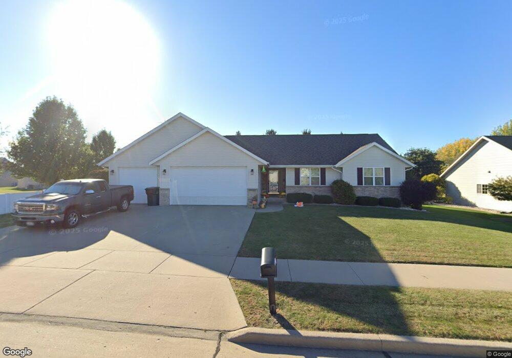
1217 Saunders Rd Kaukauna, WI 54130
Estimated Value: $317,000 - $370,000
3
Beds
2
Baths
1,494
Sq Ft
$234/Sq Ft
Est. Value
About This Home
This home is located at 1217 Saunders Rd, Kaukauna, WI 54130 and is currently estimated at $349,236, approximately $233 per square foot. 1217 Saunders Rd is a home located in Outagamie County with nearby schools including River View School, Kaukauna High School, and New Directions Learning Community.
Ownership History
Date
Name
Owned For
Owner Type
Purchase Details
Closed on
Oct 27, 2017
Bought by
Gustafson Malcolm J
Current Estimated Value
Home Financials for this Owner
Home Financials are based on the most recent Mortgage that was taken out on this home.
Original Mortgage
$144,900
Outstanding Balance
$121,707
Interest Rate
3.94%
Estimated Equity
$227,529
Create a Home Valuation Report for This Property
The Home Valuation Report is an in-depth analysis detailing your home's value as well as a comparison with similar homes in the area
Home Values in the Area
Average Home Value in this Area
Purchase History
| Date | Buyer | Sale Price | Title Company |
|---|---|---|---|
| Gustafson Malcolm J | $207,000 | -- |
Source: Public Records
Mortgage History
| Date | Status | Borrower | Loan Amount |
|---|---|---|---|
| Open | Gustafson Malcolm J | $144,900 | |
| Closed | Gustafson Malcolm J | -- |
Source: Public Records
Tax History Compared to Growth
Tax History
| Year | Tax Paid | Tax Assessment Tax Assessment Total Assessment is a certain percentage of the fair market value that is determined by local assessors to be the total taxable value of land and additions on the property. | Land | Improvement |
|---|---|---|---|---|
| 2023 | $4,447 | $232,400 | $34,700 | $197,700 |
| 2022 | $4,156 | $232,400 | $34,700 | $197,700 |
| 2021 | $3,949 | $232,400 | $34,700 | $197,700 |
| 2020 | $3,763 | $169,500 | $29,800 | $139,700 |
| 2019 | $3,758 | $169,500 | $29,800 | $139,700 |
| 2018 | $3,787 | $169,500 | $29,800 | $139,700 |
| 2017 | $3,786 | $169,500 | $29,800 | $139,700 |
| 2016 | $3,606 | $169,500 | $29,800 | $139,700 |
| 2015 | $3,622 | $169,500 | $29,800 | $139,700 |
| 2014 | $4,079 | $169,500 | $29,800 | $139,700 |
| 2013 | $4,124 | $169,500 | $29,800 | $139,700 |
Source: Public Records
Map
Nearby Homes
- 1207 Saunders Rd
- 708 Westfield St
- 607 Debruin Rd
- 580 W Henry St
- 412 Buchanan Rd
- 107 Lamine Ln
- 3005 Crooks Ave
- 592 Cornrow Ln
- 2205 Welhouse Dr
- 435 Roger St
- W2286 Valleywood Ln
- 1601 Main Ave
- W2313 Saint Germaine Ct
- 216 E 17th St
- 304 E 17th St
- 123 W 10th St
- 387 Riverview Ridge Place
- 445 Riverview Ridge Place
- 393 Farmhouse Ln
- 391 Riverview Ridge Place
- 1219 Saunders Rd
- 1302 Moon Ridge Ct
- 1102 Matthew Ln
- 1221 Saunders Rd
- 1220 Saunders Rd
- 1311 W Ann St
- 1101 Matthew Ln
- 1317 W Ann St
- 1020 Matthew Ln
- 1101 W Ann St
- 1021 Matthew Ln
- 1323 Moon Ridge Ct
- 1310 Moon Ridge Ct
- 1341 Moon Ridge Ct
- 1346 Moon Ridge Ct
- 1321 Moon Ridge Ct
- 1338 Moon Ridge Ct
- 1342 Moon Ridge Ct
- 1350 Moon Ridge Ct
- 1301 Moon Ridge Ct