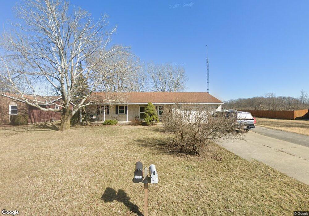
12179 Township Road 77 Findlay, OH 45840
Estimated Value: $212,000 - $249,435
3
Beds
2
Baths
1,568
Sq Ft
$148/Sq Ft
Est. Value
About This Home
This home is located at 12179 Township Road 77, Findlay, OH 45840 and is currently estimated at $232,609, approximately $148 per square foot. 12179 Township Road 77 is a home located in Hancock County with nearby schools including Liberty-Benton Elementary School, Liberty-Benton Middle School, and Liberty-Benton High School.
Ownership History
Date
Name
Owned For
Owner Type
Purchase Details
Closed on
Dec 15, 2023
Sold by
Noyes Timothy Charles and Noyes Karen Ann
Bought by
Noyes Timothy Charles and Noyes Karen Ann
Current Estimated Value
Purchase Details
Closed on
Jan 25, 1985
Bought by
Noyes Timothy C and Noyes Karen E
Purchase Details
Closed on
Feb 15, 1984
Bought by
Sines Timothy J
Create a Home Valuation Report for This Property
The Home Valuation Report is an in-depth analysis detailing your home's value as well as a comparison with similar homes in the area
Home Values in the Area
Average Home Value in this Area
Purchase History
| Date | Buyer | Sale Price | Title Company |
|---|---|---|---|
| Noyes Timothy Charles | -- | None Listed On Document | |
| Noyes Timothy Charles | -- | None Listed On Document | |
| Noyes Timothy C | $63,500 | -- | |
| Sines Timothy J | -- | -- |
Source: Public Records
Tax History Compared to Growth
Tax History
| Year | Tax Paid | Tax Assessment Tax Assessment Total Assessment is a certain percentage of the fair market value that is determined by local assessors to be the total taxable value of land and additions on the property. | Land | Improvement |
|---|---|---|---|---|
| 2024 | $2,120 | $59,780 | $12,970 | $46,810 |
| 2023 | $2,068 | $59,780 | $12,970 | $46,810 |
| 2022 | $2,047 | $59,780 | $12,970 | $46,810 |
| 2021 | $2,036 | $50,390 | $12,940 | $37,450 |
| 2020 | $1,975 | $50,390 | $12,940 | $37,450 |
| 2019 | $1,945 | $50,390 | $12,940 | $37,450 |
| 2018 | $1,523 | $43,810 | $11,250 | $32,560 |
| 2017 | $785 | $43,810 | $11,250 | $32,560 |
| 2016 | $1,531 | $43,810 | $11,250 | $32,560 |
| 2015 | $1,630 | $45,730 | $11,250 | $34,480 |
| 2014 | $1,613 | $44,580 | $11,250 | $33,330 |
| 2012 | $1,576 | $41,800 | $8,470 | $33,330 |
Source: Public Records
Map
Nearby Homes
- 0 Penrose Dr
- 3323 Western Ave
- 0 Township Road 77
- 3065 S Main St
- 0 Virbunum Ct Unit 87 305267
- 0 Viburnum Ct Unit 20243687
- 0 Viburnum Ct Unit 6121366
- 500 Blue Bonnet Dr
- 164 Church Hill Dr
- 128 Church Hill Dr
- 2010 S Main St
- 0 Township Road 227
- 11787 County Road 180
- 1609 Foraker Ave
- 1421 Hurd Ave
- 1818 Westview Dr
- 13385 Deer Landing Dr
- 1815 Eastview Dr
- 1726 Eastview Dr
- 0 Bushwillow Dr Unit Lot 156
- 12165 Township Road 77
- 12151 Township Road 77
- 12205 Township Road 77
- 12178 Township Road 77
- 12233 Township Road 77
- 12158 Township Road 77
- 12123 Township Road 77
- 12210 Township Road 77
- 12132 Township Road 77
- 12228 Township Road 77
- 12109 Township Road 77
- 12120 Township Road 77
- 12097 Township Rd 77 County Rd
- 12128 Township Road 77
- 12069 Township Road 77
- 12078 Township Road 77
- 12055 Township Road 77
- 12039 Township Road 77
- 12036 Township Road 77
- 3601 Western Ave