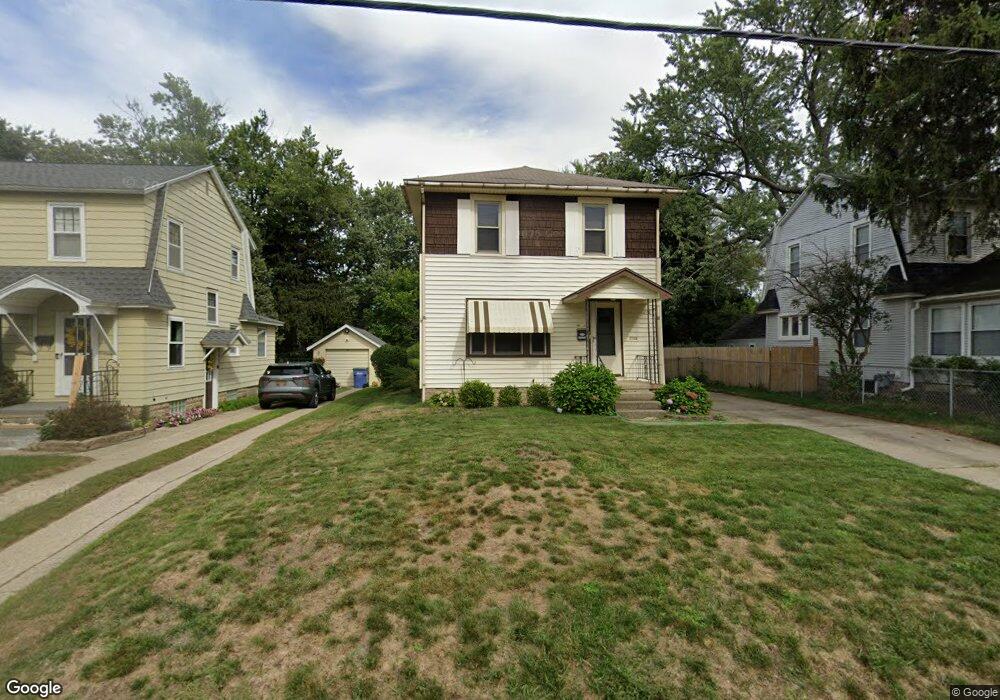
1218 Carlton Ave NE Grand Rapids, MI 49505
North East Citizens Action NeighborhoodEstimated Value: $247,841 - $275,000
--
Bed
--
Bath
1,248
Sq Ft
$214/Sq Ft
Est. Value
About This Home
This home is located at 1218 Carlton Ave NE, Grand Rapids, MI 49505 and is currently estimated at $266,960, approximately $213 per square foot. 1218 Carlton Ave NE is a home located in Kent County with nearby schools including Kent Hills School, Riverside Middle School, and Union High School.
Ownership History
Date
Name
Owned For
Owner Type
Purchase Details
Closed on
Oct 3, 2016
Sold by
Davis Alison M
Bought by
Herrington David E
Current Estimated Value
Purchase Details
Closed on
Dec 15, 2010
Sold by
Thatcher Phyllis A and Douglas K Herrington Revocable
Bought by
Herrington David E
Purchase Details
Closed on
Mar 13, 2009
Sold by
Thatcher Phyllis A and Herrington Douglas K
Bought by
Thatcher Phyllis A and Douglas K Herrington Revocable
Purchase Details
Closed on
Oct 7, 1986
Create a Home Valuation Report for This Property
The Home Valuation Report is an in-depth analysis detailing your home's value as well as a comparison with similar homes in the area
Home Values in the Area
Average Home Value in this Area
Purchase History
| Date | Buyer | Sale Price | Title Company |
|---|---|---|---|
| Herrington David E | -- | None Available | |
| Herrington David E | $60,500 | None Available | |
| Thatcher Phyllis A | -- | None Available | |
| -- | $12,700 | -- |
Source: Public Records
Tax History Compared to Growth
Tax History
| Year | Tax Paid | Tax Assessment Tax Assessment Total Assessment is a certain percentage of the fair market value that is determined by local assessors to be the total taxable value of land and additions on the property. | Land | Improvement |
|---|---|---|---|---|
| 2025 | $1,442 | $116,900 | $0 | $0 |
| 2024 | $1,442 | $107,100 | $0 | $0 |
| 2023 | $1,464 | $92,700 | $0 | $0 |
| 2022 | $1,389 | $79,400 | $0 | $0 |
| 2021 | $1,358 | $73,900 | $0 | $0 |
| 2020 | $1,299 | $69,400 | $0 | $0 |
| 2019 | $1,360 | $61,400 | $0 | $0 |
| 2018 | $1,314 | $53,400 | $0 | $0 |
| 2017 | $1,279 | $41,000 | $0 | $0 |
| 2016 | $1,294 | $38,200 | $0 | $0 |
| 2015 | $1,204 | $38,200 | $0 | $0 |
| 2013 | -- | $35,400 | $0 | $0 |
Source: Public Records
Map
Nearby Homes
- 1238 Carlton Ave NE
- 1332 Leonard St NE
- 1250 Mayfield Ave NE
- 1452 Carlton Ave NE
- 1339 Fuller Ave NE
- 1119 Spencer St NE
- 1455 Ball Ave NE
- 1518 Mayfield Ave NE
- 1060 Leonard St NE
- 1100 Coldbrook St NE
- 1228 Spring Ave NE
- 1444 Sweet St NE
- 1524 Sweet St NE
- 1535 Mason St NE
- 1209 Mason St NE
- 1539 Mason St NE
- 1150 Diamond Ave NE
- 1256 Diamond Ave NE
- 1659 Mason St NE
- 914 Leonard St NE
- 1214 Carlton Ave NE
- 1224 Carlton Ave NE
- 1230 Carlton Ave NE
- 1213 Lewison Ave NE
- 1225 Lewison Ave NE
- 1411 Leonard St NE
- 1234 Carlton Ave NE
- 1415 Leonard St NE
- 1405 Leonard St NE
- 1231 Lewison Ave NE
- 1419 Leonard St NE
- 1221 Carlton Ave NE
- 1423 Leonard St NE
- 1235 Lewison Ave NE
- 1227 Carlton Ave NE
- 1361 Leonard St NE
- 1427 Leonard St NE
- 1239 Lewison Ave NE
- 1231 Carlton Ave NE
- 1242 Carlton Ave NE