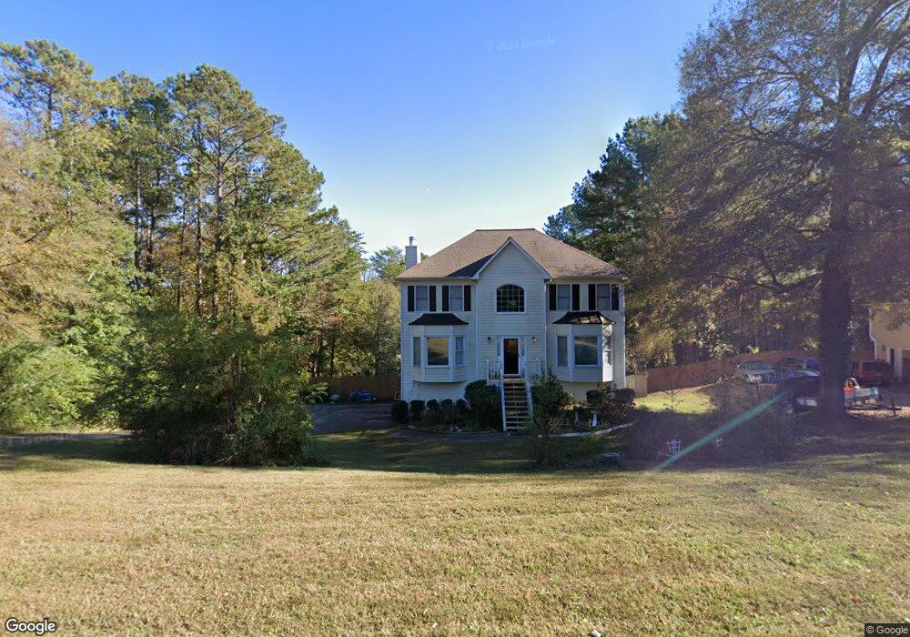
1218 Palm Ridge Trace Canton, GA 30115
Estimated Value: $429,479 - $480,000
4
Beds
3
Baths
2,098
Sq Ft
$217/Sq Ft
Est. Value
About This Home
This home is located at 1218 Palm Ridge Trace, Canton, GA 30115 and is currently estimated at $454,740, approximately $216 per square foot. 1218 Palm Ridge Trace is a home located in Cherokee County with nearby schools including Holly Springs Elementary School, Rusk Middle School, and Sequoyah High School.
Ownership History
Date
Name
Owned For
Owner Type
Purchase Details
Closed on
Oct 21, 2011
Sold by
Jenkins Ebony R
Bought by
Sunday Kay L
Current Estimated Value
Home Financials for this Owner
Home Financials are based on the most recent Mortgage that was taken out on this home.
Original Mortgage
$119,988
Outstanding Balance
$80,620
Interest Rate
3.87%
Mortgage Type
FHA
Estimated Equity
$374,120
Purchase Details
Closed on
Jul 29, 1999
Sold by
Finch Michael and Finch Margaret
Bought by
Jenkins Kay L and Jenkins Ebony R
Home Financials for this Owner
Home Financials are based on the most recent Mortgage that was taken out on this home.
Original Mortgage
$147,900
Interest Rate
7.58%
Mortgage Type
FHA
Create a Home Valuation Report for This Property
The Home Valuation Report is an in-depth analysis detailing your home's value as well as a comparison with similar homes in the area
Home Values in the Area
Average Home Value in this Area
Purchase History
| Date | Buyer | Sale Price | Title Company |
|---|---|---|---|
| Sunday Kay L | $148,000 | -- | |
| Jenkins Kay L | $148,000 | -- |
Source: Public Records
Mortgage History
| Date | Status | Borrower | Loan Amount |
|---|---|---|---|
| Open | Sunday Kay L | $119,988 | |
| Previous Owner | Jenkins Kay L | $147,900 |
Source: Public Records
Tax History Compared to Growth
Tax History
| Year | Tax Paid | Tax Assessment Tax Assessment Total Assessment is a certain percentage of the fair market value that is determined by local assessors to be the total taxable value of land and additions on the property. | Land | Improvement |
|---|---|---|---|---|
| 2025 | $3,782 | $150,960 | $30,000 | $120,960 |
| 2024 | $720 | $150,388 | $30,000 | $120,388 |
| 2023 | $710 | $156,816 | $34,000 | $122,816 |
| 2022 | $725 | $125,608 | $25,600 | $100,008 |
| 2021 | $311 | $95,040 | $19,600 | $75,440 |
| 2020 | $680 | $96,640 | $19,000 | $77,640 |
| 2019 | $313 | $91,400 | $18,000 | $73,400 |
| 2018 | $625 | $81,120 | $15,600 | $65,520 |
| 2017 | $564 | $166,200 | $11,600 | $54,880 |
| 2016 | $334 | $164,900 | $10,400 | $55,560 |
| 2015 | $345 | $155,900 | $10,400 | $51,960 |
| 2014 | $345 | $145,200 | $10,400 | $47,680 |
Source: Public Records
Map
Nearby Homes
- 1243 Palm Ridge Trace
- 1620 Palm St
- 1414 Palm St
- 1104 Palm St
- 228 Holly Creek Way
- 203 Brookhaven Place
- 234 Holly Creek Way
- 102 Magnolia Springs Ln
- 214 Valley Brook Dr
- 550 Fox Creek Crossing
- 346 Wells Cir
- 531 Fox Creek Crossing
- 501 Ruths Dr
- 283 Wells Cir
- 279 Wells Cir
- 1557 River Park Blvd
- 251 Manous Way
- 1212 Palm Ridge Trace
- 1224 Palm Ridge Trace
- 1230 Palm Ridge Trace
- 1206 Palm Ridge Trace
- 0 Palm Ridge Trace Unit 7200713
- 1219 Palm Ridge Trace
- 1201 Palm Ridge Trace
- 1225 Palm Ridge Trace
- 1236 Palm Ridge Trace
- 1231 Palm Ridge Trace
- 1200 Palm Ridge Trace
- 1242 Palm Ridge Trace
- 1237 Palm Ridge Trace
- 1690 Palm St Unit 1
- 1248 Palm Ridge Trace
- 1249 Palm Ridge Trace
- 434 Sweetgum Dr Unit 7
- 432 Sweetgum Dr
- 121 Holly Creek Ct
- 1254 Palm Ridge Trace