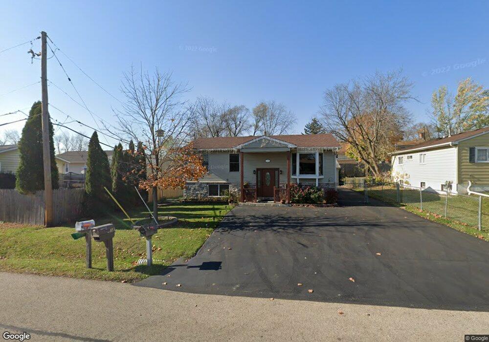
1218 Woodridge Dr Unit 1 Round Lake Beach, IL 60073
Estimated Value: $213,000 - $259,136
4
Beds
2
Baths
925
Sq Ft
$255/Sq Ft
Est. Value
About This Home
This home is located at 1218 Woodridge Dr Unit 1, Round Lake Beach, IL 60073 and is currently estimated at $235,534, approximately $254 per square foot. 1218 Woodridge Dr Unit 1 is a home located in Lake County with nearby schools including Raymond Ellis Elementary School, Round Lake Middle School, and Round Lake High School.
Ownership History
Date
Name
Owned For
Owner Type
Purchase Details
Closed on
Dec 20, 2010
Sold by
Federal Home Loan Mortgage Corporation
Bought by
Garcia Carmen
Current Estimated Value
Purchase Details
Closed on
Oct 21, 2010
Sold by
Perry Stacy R
Bought by
Federal Home Loan Mortgage Corp
Purchase Details
Closed on
Aug 1, 2006
Sold by
Perry Stacy R and Trust #1218
Bought by
Perry Stacy R
Purchase Details
Closed on
Apr 25, 2006
Sold by
Kazele Joann R
Bought by
Kazele Joann R and Trust #1218
Create a Home Valuation Report for This Property
The Home Valuation Report is an in-depth analysis detailing your home's value as well as a comparison with similar homes in the area
Home Values in the Area
Average Home Value in this Area
Purchase History
| Date | Buyer | Sale Price | Title Company |
|---|---|---|---|
| Garcia Carmen | $70,000 | Attorneys Title Guaranty Fun | |
| Federal Home Loan Mortgage Corp | -- | None Available | |
| Perry Stacy R | -- | None Available | |
| Kazele Joann R | -- | None Available |
Source: Public Records
Tax History Compared to Growth
Tax History
| Year | Tax Paid | Tax Assessment Tax Assessment Total Assessment is a certain percentage of the fair market value that is determined by local assessors to be the total taxable value of land and additions on the property. | Land | Improvement |
|---|---|---|---|---|
| 2024 | $5,099 | $69,100 | $11,058 | $58,042 |
| 2023 | $5,099 | $60,398 | $9,666 | $50,732 |
| 2022 | $4,807 | $54,368 | $8,145 | $46,223 |
| 2021 | $4,800 | $49,441 | $7,829 | $41,612 |
| 2020 | $4,587 | $47,042 | $7,449 | $39,593 |
| 2019 | $4,445 | $45,133 | $7,147 | $37,986 |
| 2018 | $3,653 | $33,613 | $6,810 | $26,803 |
| 2017 | $3,484 | $31,618 | $6,406 | $25,212 |
| 2016 | $3,312 | $29,186 | $5,913 | $23,273 |
| 2015 | $3,189 | $31,451 | $5,402 | $26,049 |
| 2014 | $1,833 | $18,147 | $5,355 | $12,792 |
| 2012 | $1,879 | $18,953 | $5,593 | $13,360 |
Source: Public Records
Map
Nearby Homes
- 905 Buena Vista Dr
- 1315 Cherokee Dr
- 915 Mayfield Dr
- 1110 N Fairfield Rd
- 1506 Brentwood Dr
- 630 Morningside Dr
- 1503 Cherokee Dr
- 1163 N Red Oak Cir Unit 4
- 347 N Red Oak Cir Unit 406
- 1248 N Red Oak Cir Unit 2
- 1160 N Red Oak Cir Unit 1160-1
- 1401 Meadowbrook Dr
- 922 Idlewild Dr
- 931 N Fairfield Rd
- 1316 N Red Oak Cir Unit 2
- 24513 W Stub Ave
- 123 Nasa Cir
- 1256 N Split Oak Cir
- 1376 W Split Oak Cir
- 1410 Juneway Terrace
- 1220 Woodridge Dr
- 818 Ronald Terrace
- 816 Ronald Terrace
- 1222 Woodridge Dr
- 1217 Brentwood Dr
- 820 Ronald Terrace
- 1219 Brentwood Dr
- 822 Ronald Terrace
- 1224 Woodridge Dr
- 1221 Brentwood Dr
- 1221 Woodridge Dr
- 1219 Woodridge Dr
- 1217 Woodridge Dr
- 1223 Woodridge Dr
- 812 Ronald Terrace
- 1302 Woodridge Dr Unit 1
- 1225 Woodridge Dr
- 1223 Brentwood Dr
- 1301 Woodridge Dr
- 1216 Brentwood Dr