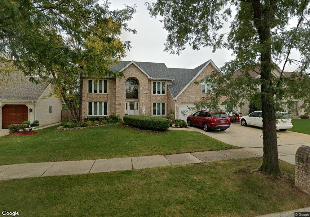
1219 W Surrey Rd Addison, IL 60101
Estimated Value: $720,000 - $811,000
6
Beds
6
Baths
4,200
Sq Ft
$181/Sq Ft
Est. Value
About This Home
This home is located at 1219 W Surrey Rd, Addison, IL 60101 and is currently estimated at $759,426, approximately $180 per square foot. 1219 W Surrey Rd is a home located in DuPage County with nearby schools including Stone Elementary School, Indian Trail Jr High School, and Addison Trail High School.
Ownership History
Date
Name
Owned For
Owner Type
Purchase Details
Closed on
Jul 7, 2008
Sold by
Theros Dennis and Theros Androniki
Bought by
Theros Dennis and Theros Androniki
Current Estimated Value
Purchase Details
Closed on
Nov 23, 1999
Sold by
Damore Vito N and Damore Clara
Bought by
Theros Dennis and Theros Androniki
Home Financials for this Owner
Home Financials are based on the most recent Mortgage that was taken out on this home.
Original Mortgage
$200,000
Interest Rate
7.9%
Purchase Details
Closed on
May 2, 1997
Sold by
Powalish Jerome J and Powalish Peggy A
Bought by
Damore Vito N and Damore Clara
Home Financials for this Owner
Home Financials are based on the most recent Mortgage that was taken out on this home.
Original Mortgage
$250,000
Interest Rate
8.87%
Create a Home Valuation Report for This Property
The Home Valuation Report is an in-depth analysis detailing your home's value as well as a comparison with similar homes in the area
Home Values in the Area
Average Home Value in this Area
Purchase History
| Date | Buyer | Sale Price | Title Company |
|---|---|---|---|
| Theros Dennis | -- | None Available | |
| Theros Dennis | $465,500 | -- | |
| Damore Vito N | $408,000 | Attorneys Title Guaranty Fun |
Source: Public Records
Mortgage History
| Date | Status | Borrower | Loan Amount |
|---|---|---|---|
| Closed | Theros Dennis | $200,000 | |
| Previous Owner | Damore Vito N | $250,000 |
Source: Public Records
Tax History Compared to Growth
Tax History
| Year | Tax Paid | Tax Assessment Tax Assessment Total Assessment is a certain percentage of the fair market value that is determined by local assessors to be the total taxable value of land and additions on the property. | Land | Improvement |
|---|---|---|---|---|
| 2024 | $16,096 | $236,379 | $51,703 | $184,676 |
| 2023 | $15,407 | $217,300 | $47,530 | $169,770 |
| 2022 | $14,975 | $209,330 | $45,490 | $163,840 |
| 2021 | $14,365 | $200,500 | $43,570 | $156,930 |
| 2020 | $13,993 | $192,050 | $41,730 | $150,320 |
| 2019 | $13,912 | $184,660 | $40,120 | $144,540 |
| 2018 | $13,791 | $175,880 | $38,950 | $136,930 |
| 2017 | $13,455 | $168,100 | $37,230 | $130,870 |
| 2016 | $13,131 | $155,200 | $34,370 | $120,830 |
| 2015 | $12,841 | $143,370 | $31,750 | $111,620 |
| 2014 | $11,914 | $132,630 | $29,110 | $103,520 |
| 2013 | $11,663 | $135,330 | $29,700 | $105,630 |
Source: Public Records
Map
Nearby Homes
- 1202 W Surrey Rd
- 1065 N Jamey Ln
- 1275 W Lake St Unit 104
- 1210 N Foxdale Dr Unit 109
- 4N327 7th Ave
- 19W720 Woodland Ave
- 551 N 6th Ave
- 580 N Highlander Way
- 1155 W Westwood Trail
- 1660 W Prescott Place
- 1527 W Holtz Ave
- 1520 W Grove St
- 661 N Briar Hill Ln Unit 5
- 5N210 Central Rd
- 943 N Rohlwing Rd Unit 101H
- 953 N Rohlwing Rd Unit GB
- 465 W Dominion Dr Unit 1302
- 465 W Dominion Dr Unit 1001
- 818 N Rumple Ln
- 1750 W Woodland Ave
- 1215 W Surrey Rd
- 1223 W Surrey Rd
- 1211 W Surrey Rd
- 1207 W Surrey Rd
- 1101 N Thatcher Ln
- 1108 N Thatcher Ln
- 1105 N Thatcher Ln
- 1208 W Surrey Rd
- 1250 W Lake St
- 1203 W Surrey Rd
- 1080 N 8th Ave
- 1100 N 8th Ave
- 1070 N 8th Ave
- 1210 W Surrey Rd
- 1109 N Thatcher Ln
- 1216 W Surrey Rd
- 1114 N Thatcher Ln
- 1104 N 8th Ave
- 1060 N 8th Ave
- 1214 W Surrey Rd