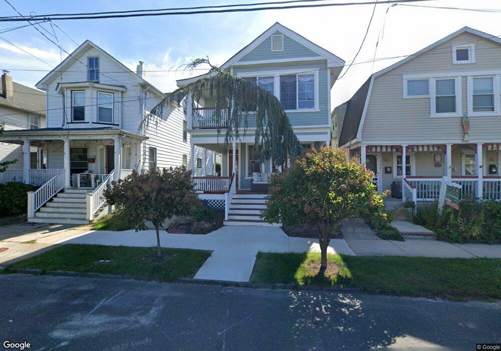
122 Broadway Ocean Grove, NJ 07756
Estimated Value: $756,000 - $940,000
3
Beds
2
Baths
1,251
Sq Ft
$647/Sq Ft
Est. Value
About This Home
This home is located at 122 Broadway, Ocean Grove, NJ 07756 and is currently estimated at $808,857, approximately $646 per square foot. 122 Broadway is a home located in Monmouth County with nearby schools including Neptune High School, Hope Academy Charter School, and Our Lady of Mount Carmel School.
Ownership History
Date
Name
Owned For
Owner Type
Purchase Details
Closed on
Aug 25, 2003
Sold by
Williams Jeffrey
Bought by
Bunton Corbett and Bunton Francine
Current Estimated Value
Home Financials for this Owner
Home Financials are based on the most recent Mortgage that was taken out on this home.
Original Mortgage
$150,000
Interest Rate
6.43%
Purchase Details
Closed on
Aug 12, 1994
Sold by
Rodgers William
Bought by
Smith Ralph
Home Financials for this Owner
Home Financials are based on the most recent Mortgage that was taken out on this home.
Original Mortgage
$85,000
Interest Rate
8.65%
Mortgage Type
VA
Create a Home Valuation Report for This Property
The Home Valuation Report is an in-depth analysis detailing your home's value as well as a comparison with similar homes in the area
Home Values in the Area
Average Home Value in this Area
Purchase History
| Date | Buyer | Sale Price | Title Company |
|---|---|---|---|
| Bunton Corbett | $279,000 | -- | |
| Smith Ralph | $85,000 | -- |
Source: Public Records
Mortgage History
| Date | Status | Borrower | Loan Amount |
|---|---|---|---|
| Previous Owner | Bunton Corbett | $150,000 | |
| Previous Owner | Smith Ralph | $85,000 |
Source: Public Records
Tax History Compared to Growth
Tax History
| Year | Tax Paid | Tax Assessment Tax Assessment Total Assessment is a certain percentage of the fair market value that is determined by local assessors to be the total taxable value of land and additions on the property. | Land | Improvement |
|---|---|---|---|---|
| 2025 | $12,442 | $707,400 | $423,800 | $283,600 |
| 2024 | $9,780 | $723,800 | $420,300 | $303,500 |
| 2023 | $9,780 | $551,300 | $366,100 | $185,200 |
| 2022 | $8,590 | $498,900 | $342,100 | $156,800 |
| 2021 | $7,858 | $413,600 | $293,100 | $120,500 |
| 2020 | $8,311 | $398,600 | $284,400 | $114,200 |
| 2019 | $7,858 | $371,900 | $264,700 | $107,200 |
| 2018 | $7,500 | $351,300 | $244,900 | $106,400 |
| 2017 | $9,754 | $438,200 | $339,700 | $98,500 |
| 2016 | $9,482 | $425,200 | $235,000 | $190,200 |
| 2015 | $7,472 | $341,200 | $222,400 | $118,800 |
Source: Public Records
Map
Nearby Homes
- 128 Broadway
- 139 Cookman Ave
- 139 Stockton Ave
- 137 Inskip Ave
- 140 Stockton Ave
- 146 Inskip Ave
- 81 Inskip Ave
- 77 Stockton Ave
- 147 Webb Ave
- 69 Stockton Ave
- 69 Webb Ave
- 1003 Hammond Ave
- 93 Central Ave
- 56 Embury Ave
- 77 Main Ave Unit 2B
- 77 Main Ave Unit 2A
- 219 Lake Terrace
- 66 Main Ave
- 110 Mount Tabor Way
- 52 Embury Ave
- 124 Broadway
- 124 Broadway Unit 1
- 124 Broadway Unit Annual
- 120 Broadway
- 126 Broadway
- 123 Cookman Ave
- 119 Cookman Ave
- 125 Cookman Ave
- 117 Cookman Ave
- 116 Broadway
- 115 Cookman Ave
- 118 Whitefield Ave Unit 118
- 118 Whitefield Ave Unit 218
- 122 Whitefield Ave
- 127 Cookman Ave
- 121 Broadway
- 130 Broadway
- 123 Broadway
- 119 Broadway
- 114 Broadway