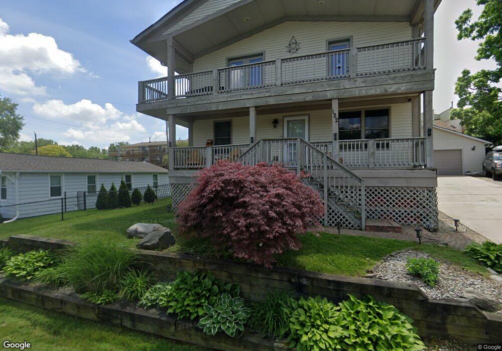
122 Coalmont St Unit Bldg-Unit Walled Lake, MI 48390
Estimated Value: $548,000 - $594,000
3
Beds
3
Baths
2,316
Sq Ft
$250/Sq Ft
Est. Value
About This Home
This home is located at 122 Coalmont St Unit Bldg-Unit, Walled Lake, MI 48390 and is currently estimated at $579,344, approximately $250 per square foot. 122 Coalmont St Unit Bldg-Unit is a home located in Oakland County with nearby schools including Walled Lake Elementary School, Sarah G. Banks Middle School, and Walled Lake Western High School.
Ownership History
Date
Name
Owned For
Owner Type
Purchase Details
Closed on
Feb 28, 2018
Sold by
Cresswell Joshua P and Cresswell Gail
Bought by
Maurer Michael
Current Estimated Value
Purchase Details
Closed on
Mar 25, 1997
Sold by
Mexicotte Donald Wayne
Bought by
Mexicotte Kathleen Marie
Home Financials for this Owner
Home Financials are based on the most recent Mortgage that was taken out on this home.
Original Mortgage
$36,000
Interest Rate
7.92%
Create a Home Valuation Report for This Property
The Home Valuation Report is an in-depth analysis detailing your home's value as well as a comparison with similar homes in the area
Home Values in the Area
Average Home Value in this Area
Purchase History
| Date | Buyer | Sale Price | Title Company |
|---|---|---|---|
| Maurer Michael | -- | Liberty Title | |
| Cooper Jeremiah | $325,000 | None Available | |
| Mexicotte Kathleen Marie | $9,200 | -- |
Source: Public Records
Mortgage History
| Date | Status | Borrower | Loan Amount |
|---|---|---|---|
| Previous Owner | Mexicotte Kathleen Marie | $36,000 |
Source: Public Records
Tax History Compared to Growth
Tax History
| Year | Tax Paid | Tax Assessment Tax Assessment Total Assessment is a certain percentage of the fair market value that is determined by local assessors to be the total taxable value of land and additions on the property. | Land | Improvement |
|---|---|---|---|---|
| 2024 | $7,734 | $265,740 | $0 | $0 |
| 2023 | $7,288 | $230,340 | $0 | $0 |
| 2022 | $7,296 | $221,180 | $0 | $0 |
| 2021 | $7,392 | $218,810 | $0 | $0 |
| 2020 | $7,025 | $170,000 | $0 | $0 |
| 2019 | $9,204 | $211,510 | $0 | $0 |
| 2018 | $6,600 | $202,390 | $0 | $0 |
| 2017 | $8,855 | $188,560 | $0 | $0 |
| 2016 | $8,173 | $165,410 | $0 | $0 |
| 2015 | -- | $0 | $0 | $0 |
Source: Public Records
Map
Nearby Homes
- 855 S Pontiac Trail Unit A205
- 895 S Pontiac Trail Unit 203
- 44800 Bayview Dr Unit 33
- 149 N Haven St
- 44847 Larkspur Unit 9
- 1254 Glenwood Ct
- 1249 Glenwood Ct
- 325 Glenwood Dr Unit 12
- 1900 S Lake Ct
- 1640 High Pointe Dr
- 461 Alexander Dr
- 132 Copper Ridge Ct
- 1035 E Walled Lake Dr
- 420 Wellsboro St
- 464 Old Pine Way Unit 159
- 413 Village Dr Unit 174
- 433 Village Dr Unit 189
- 470 Old Pine Way Unit 162
- 157 E Bay Dr
- 439 Village Dr Unit 184
- 122 Coalmont St
- 118 Coalmont St
- 0 Bayveiw Unit 4911216
- 0 Bayveiw Unit 213032737
- 128 Coalmont St
- 108 Coalmont St
- 117 Coalmont St
- 129 Coalmont St
- 113 Coalmont St
- 132 Coalmont St
- 131 Coalmont St
- 875 S Pontiac Trail Unit 201
- 875 S Pontiac Trail
- 134 Coalmont St
- 875 S Pontiac Trail Unit 302
- 875 S Pontiac Trail Unit 306
- 875 S Pontiac Trail Unit 203
- 875 S Pontiac Trail
- 875 S Pontiac Trail
- 875 S Pontiac Trail