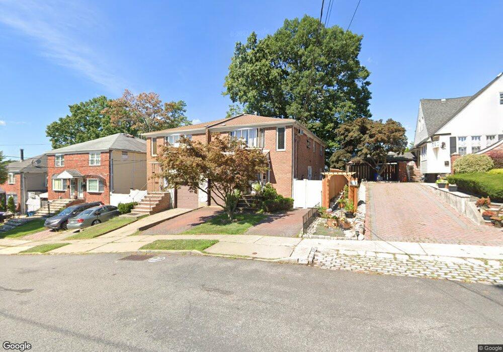
122 Dalton Ave Staten Island, NY 10306
New Dorp NeighborhoodEstimated Value: $722,708 - $1,227,000
--
Bed
--
Bath
1,720
Sq Ft
$549/Sq Ft
Est. Value
About This Home
This home is located at 122 Dalton Ave, Staten Island, NY 10306 and is currently estimated at $943,677, approximately $548 per square foot. 122 Dalton Ave is a home located in Richmond County with nearby schools including P.S. 23 Richmondtown, Myra S. Barnes Intermediate School 24, and New Dorp High School.
Ownership History
Date
Name
Owned For
Owner Type
Purchase Details
Closed on
Aug 14, 2024
Sold by
Heaney Michael P
Bought by
122 Michael P Heaney Irrevocable Real Estate and Heaney
Current Estimated Value
Purchase Details
Closed on
Feb 14, 2006
Sold by
Heaney Christine and Heaney Michael P
Bought by
Heaney Michael P
Purchase Details
Closed on
Jun 29, 2001
Sold by
Heaney Christine
Bought by
Heaney Christine and Heaney Michael P
Purchase Details
Closed on
Aug 9, 1995
Sold by
Kirchhoffer George H and Kirchhoffer Susie H
Bought by
Heaney Michael F and Heaney Christine
Create a Home Valuation Report for This Property
The Home Valuation Report is an in-depth analysis detailing your home's value as well as a comparison with similar homes in the area
Home Values in the Area
Average Home Value in this Area
Purchase History
| Date | Buyer | Sale Price | Title Company |
|---|---|---|---|
| 122 Michael P Heaney Irrevocable Real Estate | -- | None Listed On Document | |
| Heaney Michael P | -- | The Judicial Title Insurance | |
| Heaney Christine | -- | First American Title Ins Co | |
| Heaney Michael F | $185,000 | -- |
Source: Public Records
Tax History Compared to Growth
Tax History
| Year | Tax Paid | Tax Assessment Tax Assessment Total Assessment is a certain percentage of the fair market value that is determined by local assessors to be the total taxable value of land and additions on the property. | Land | Improvement |
|---|---|---|---|---|
| 2025 | $6,889 | $47,340 | $7,972 | $39,368 |
| 2024 | $6,889 | $41,640 | $8,551 | $33,089 |
| 2023 | $6,966 | $34,301 | $7,308 | $26,993 |
| 2022 | $6,796 | $41,820 | $10,380 | $31,440 |
| 2021 | $6,759 | $39,660 | $10,380 | $29,280 |
| 2020 | $6,413 | $36,300 | $10,380 | $25,920 |
| 2019 | $5,980 | $37,860 | $10,380 | $27,480 |
| 2018 | $5,827 | $28,584 | $9,583 | $19,001 |
| 2017 | $5,783 | $28,368 | $9,975 | $18,393 |
| 2016 | $5,350 | $26,763 | $9,686 | $17,077 |
| 2015 | $4,571 | $25,249 | $8,792 | $16,457 |
| 2014 | $4,571 | $23,820 | $8,880 | $14,940 |
Source: Public Records
Map
Nearby Homes
- 124 Dalton Ave
- 126 Dalton Ave
- 116 Dalton Ave
- 130 Dalton Ave
- 132 Dalton Ave
- 105 Cranford Ave
- 103 Cranford Ave
- 107 Cranford Ave
- 101 Cranford Ave
- 136 Dalton Ave
- 99 Cranford Ave
- 111 Cranford Ave
- 113 Cranford Ave
- 97 Cranford Ave
- 138 Dalton Ave
- 120 Vincent Ave
- 117 Cranford Ave
- 108 Dalton Ave
- 117 Dalton Ave
- 93 Cranford Ave