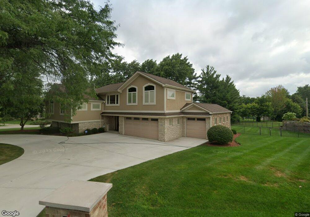
122 E Niagara Ave Schaumburg, IL 60193
South Schaumburg NeighborhoodEstimated Value: $539,000 - $609,000
4
Beds
4
Baths
2,377
Sq Ft
$244/Sq Ft
Est. Value
About This Home
This home is located at 122 E Niagara Ave, Schaumburg, IL 60193 and is currently estimated at $580,275, approximately $244 per square foot. 122 E Niagara Ave is a home located in Cook County with nearby schools including Frederick Nerge Elementary School, Margaret Mead Junior High School, and J B Conant High School.
Ownership History
Date
Name
Owned For
Owner Type
Purchase Details
Closed on
Apr 24, 2004
Sold by
Delsasso John M and Delsasso Sheri L
Bought by
Kowalski William J and Kowalski Donna H
Current Estimated Value
Home Financials for this Owner
Home Financials are based on the most recent Mortgage that was taken out on this home.
Original Mortgage
$294,000
Outstanding Balance
$137,588
Interest Rate
5.91%
Mortgage Type
Unknown
Estimated Equity
$442,687
Purchase Details
Closed on
Mar 18, 1998
Sold by
Delsasso John M and Delsasso Sheri L
Bought by
Delsasso John M and Delsasso Sheri L
Create a Home Valuation Report for This Property
The Home Valuation Report is an in-depth analysis detailing your home's value as well as a comparison with similar homes in the area
Home Values in the Area
Average Home Value in this Area
Purchase History
| Date | Buyer | Sale Price | Title Company |
|---|---|---|---|
| Kowalski William J | $394,000 | Multiple | |
| Delsasso John M | -- | -- |
Source: Public Records
Mortgage History
| Date | Status | Borrower | Loan Amount |
|---|---|---|---|
| Open | Kowalski William J | $294,000 |
Source: Public Records
Tax History
| Year | Tax Paid | Tax Assessment Tax Assessment Total Assessment is a certain percentage of the fair market value that is determined by local assessors to be the total taxable value of land and additions on the property. | Land | Improvement |
|---|---|---|---|---|
| 2025 | $13,077 | $59,000 | $11,299 | $47,701 |
| 2024 | $13,077 | $50,000 | $10,044 | $39,956 |
| 2023 | $12,653 | $50,000 | $10,044 | $39,956 |
| 2022 | $12,653 | $50,000 | $10,044 | $39,956 |
| 2021 | $10,267 | $37,204 | $28,247 | $8,957 |
| 2020 | $10,158 | $37,204 | $28,247 | $8,957 |
| 2019 | $10,161 | $41,338 | $28,247 | $13,091 |
| 2018 | $11,529 | $41,850 | $23,853 | $17,997 |
| 2017 | $11,365 | $41,850 | $23,853 | $17,997 |
| 2016 | $10,870 | $41,850 | $23,853 | $17,997 |
| 2015 | $10,486 | $37,675 | $20,087 | $17,588 |
| 2014 | $10,388 | $37,675 | $20,087 | $17,588 |
| 2013 | $10,104 | $37,675 | $20,087 | $17,588 |
Source: Public Records
Map
Nearby Homes
- 1326 Summit Dr
- 20 Shore Dr
- 1100 Boston Harbor Unit 7004
- 411 Drake Cir Unit 401B
- 134 Lunt Ave
- 518 E Niagara Ave
- 207 Mountain Interval Rd Unit 7230
- 240 Warren Ln Unit 11348
- 232 Warren Ln Unit 11546
- 1064 Hampton Harbor Unit 1064
- 1500 Illinois St
- 1055 Hampton Harbor Unit 1055
- 100 Pratt Blvd
- 1630 Myrtle Park St
- 620 S Point Dr
- 235 Quincy Ct
- 733 Limerick Ln Unit 7333D
- 717 Killarney Ct Unit 2D
- 725 Limerick Ln Unit 2-B
- 829 Sienna Dr
- 130 E Niagara Ave
- 1217 Laurel Ln
- 1235 Laurel Ln
- 1216 Laurel Ln
- 1222 Laurel Ln
- 1211 Laurel Ln
- 1228 Laurel Ln
- 1226 Greenview Ct
- 1295 Laurel Ln
- 1208 Laurel Ln
- 133 E Niagara Ave
- 1218 Greenview Ct
- 1234 Laurel Ln
- 111 E Wise Rd
- 201 E Niagara Ave
- 1300 Laurel Ln
- 1307 Laurel Ln
- 105 E Wise Rd
- 211 E Niagara Ave
- 1214 Greenview Ct
Your Personal Tour Guide
Ask me questions while you tour the home.