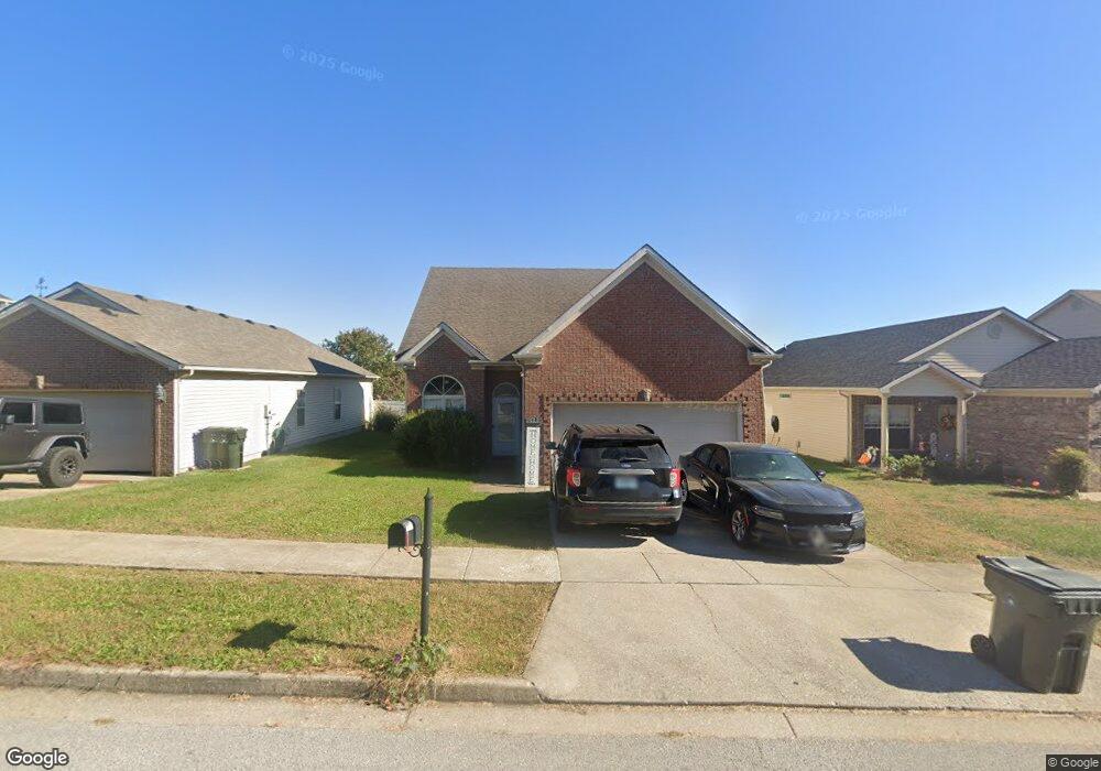
122 Felix St Georgetown, KY 40324
Northeast Georgetown NeighborhoodEstimated Value: $298,994 - $324,000
4
Beds
3
Baths
1,861
Sq Ft
$166/Sq Ft
Est. Value
About This Home
This home is located at 122 Felix St, Georgetown, KY 40324 and is currently estimated at $308,999, approximately $166 per square foot. 122 Felix St is a home located in Scott County with nearby schools including Creekside Elementary School, Garth Elementary School, and Georgetown Middle School.
Ownership History
Date
Name
Owned For
Owner Type
Purchase Details
Closed on
Apr 16, 2010
Sold by
Disanto Anthony R and Disanto Caroline L
Bought by
Colon Samuel Peguero and Depeguero Wirdis L
Current Estimated Value
Home Financials for this Owner
Home Financials are based on the most recent Mortgage that was taken out on this home.
Original Mortgage
$153,061
Outstanding Balance
$101,640
Interest Rate
4.94%
Mortgage Type
FHA
Estimated Equity
$207,359
Purchase Details
Closed on
Mar 17, 2006
Sold by
Courtney Commons Llc
Bought by
Disanto Anthony R and Disanto Andrea N
Home Financials for this Owner
Home Financials are based on the most recent Mortgage that was taken out on this home.
Original Mortgage
$24,600
Interest Rate
6.25%
Mortgage Type
Future Advance Clause Open End Mortgage
Create a Home Valuation Report for This Property
The Home Valuation Report is an in-depth analysis detailing your home's value as well as a comparison with similar homes in the area
Home Values in the Area
Average Home Value in this Area
Purchase History
| Date | Buyer | Sale Price | Title Company |
|---|---|---|---|
| Colon Samuel Peguero | $150,000 | None Available | |
| Disanto Anthony R | $164,271 | None Available |
Source: Public Records
Mortgage History
| Date | Status | Borrower | Loan Amount |
|---|---|---|---|
| Open | Colon Samuel Peguero | $153,061 | |
| Previous Owner | Disanto Anthony R | $24,600 | |
| Previous Owner | Disanto Anthony R | $131,400 |
Source: Public Records
Tax History Compared to Growth
Tax History
| Year | Tax Paid | Tax Assessment Tax Assessment Total Assessment is a certain percentage of the fair market value that is determined by local assessors to be the total taxable value of land and additions on the property. | Land | Improvement |
|---|---|---|---|---|
| 2024 | $2,351 | $261,400 | $0 | $0 |
| 2023 | $2,235 | $246,500 | $35,000 | $211,500 |
| 2022 | $1,778 | $209,100 | $33,000 | $176,100 |
| 2021 | $1,843 | $195,600 | $33,000 | $162,600 |
| 2020 | $1,525 | $177,500 | $33,000 | $144,500 |
| 2019 | $1,482 | $169,800 | $0 | $0 |
| 2018 | $1,374 | $158,300 | $0 | $0 |
| 2017 | $1,307 | $149,900 | $0 | $0 |
| 2016 | $1,207 | $149,900 | $0 | $0 |
| 2015 | $1,199 | $149,900 | $0 | $0 |
| 2014 | $1,243 | $149,900 | $0 | $0 |
| 2011 | $96 | $155,500 | $0 | $0 |
Source: Public Records
Map
Nearby Homes
- 132 Felix St
- 114 Seth Way
- 107 Pony Place
- 115 Pickett Ln
- 121 Marjorie Place
- 116 Santa Barbara Blvd
- 106 Lake Forest Dr
- 160 Bill Perkins Ln
- 161 Bill Perkins Ln
- 148 Ruth Miller Dr
- 150 Ruth Miller Dr
- 168 Ruth Miller Dr
- 174 Ruth Miller Dr
- 145 Ruth Miller Dr
- 155 Bill Perkins Ln
- 214 Pleasant View Dr
- 145 Placid Dr
- 105 Sun Drop Ln
- 106 Meadow View Way
- Tract 2 Wahland Hall Path