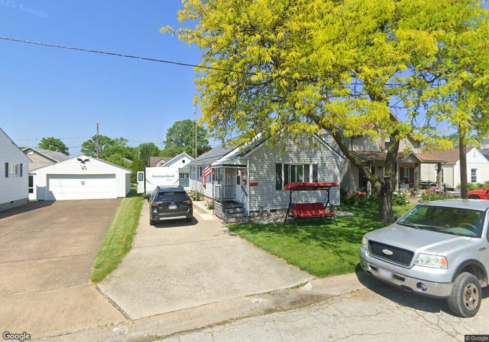
122 Linden St Port Clinton, OH 43452
Estimated Value: $148,526 - $205,000
2
Beds
1
Bath
906
Sq Ft
$192/Sq Ft
Est. Value
About This Home
This home is located at 122 Linden St, Port Clinton, OH 43452 and is currently estimated at $174,132, approximately $192 per square foot. 122 Linden St is a home located in Ottawa County with nearby schools including Bataan Memorial Primary School, Bataan Memorial Intermediate School, and Port Clinton Middle School.
Ownership History
Date
Name
Owned For
Owner Type
Purchase Details
Closed on
Dec 10, 2021
Sold by
Mitchell Dennis L
Bought by
Mitchell Dennis L and Mitchell Candy D
Current Estimated Value
Purchase Details
Closed on
Jun 11, 2018
Sold by
Mitchell Kimberly Ann
Bought by
Mitchell Denis L
Purchase Details
Closed on
Oct 14, 2005
Sold by
Shepherd Donnie E and Shepherd Karen
Bought by
Mitchell Dennis L
Home Financials for this Owner
Home Financials are based on the most recent Mortgage that was taken out on this home.
Original Mortgage
$87,805
Interest Rate
5.83%
Mortgage Type
VA
Purchase Details
Closed on
Feb 11, 1994
Sold by
Needles Irene
Bought by
Shepherd Donnie E
Create a Home Valuation Report for This Property
The Home Valuation Report is an in-depth analysis detailing your home's value as well as a comparison with similar homes in the area
Home Values in the Area
Average Home Value in this Area
Purchase History
| Date | Buyer | Sale Price | Title Company |
|---|---|---|---|
| Mitchell Dennis L | -- | Wilber And Wilber Lawyers | |
| Mitchell Denis L | -- | None Available | |
| Mitchell Dennis L | $85,000 | Port Clinton Land Title | |
| Shepherd Donnie E | -- | -- |
Source: Public Records
Mortgage History
| Date | Status | Borrower | Loan Amount |
|---|---|---|---|
| Previous Owner | Mitchell Dennis L | $87,805 |
Source: Public Records
Tax History Compared to Growth
Tax History
| Year | Tax Paid | Tax Assessment Tax Assessment Total Assessment is a certain percentage of the fair market value that is determined by local assessors to be the total taxable value of land and additions on the property. | Land | Improvement |
|---|---|---|---|---|
| 2024 | $1,231 | $35,536 | $8,932 | $26,604 |
| 2023 | $1,231 | $26,895 | $5,107 | $21,788 |
| 2022 | $1,044 | $26,895 | $5,107 | $21,788 |
| 2021 | $1,042 | $26,890 | $5,110 | $21,780 |
| 2020 | $792 | $21,420 | $3,320 | $18,100 |
| 2019 | $784 | $21,420 | $3,320 | $18,100 |
| 2018 | $783 | $21,420 | $3,320 | $18,100 |
| 2017 | $773 | $20,810 | $3,320 | $17,490 |
| 2016 | $775 | $20,810 | $3,320 | $17,490 |
| 2015 | $777 | $20,810 | $3,320 | $17,490 |
| 2014 | $376 | $19,960 | $3,320 | $16,640 |
| 2013 | $754 | $19,960 | $3,320 | $16,640 |
Source: Public Records
Map
Nearby Homes
- 116 Walnut St
- 214 Linden St
- 115 Driftwood Dr
- 1201 E 3rd St
- 35 N Beach St
- 29 N Beach St
- 164 Driftwood Dr
- 188 Driftwood Dr
- 183 Driftwood Dr
- 1801 E Perry St Unit 22
- 168 Morningside Dr
- 1807 E Perry St Unit 69
- 218 Elm St
- 801 E 3rd St
- 199 Morningside Dr
- 34 Grande Lake Dr Unit C
- 525 E 2nd St
- 521 E 2nd St
- 2321 E State Rd
- 2006 E Harbor Rd