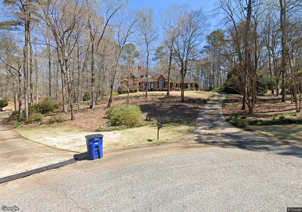
122 Red Oak Trail Lagrange, GA 30240
Estimated Value: $396,000 - $500,000
4
Beds
3
Baths
2,715
Sq Ft
$163/Sq Ft
Est. Value
About This Home
This home is located at 122 Red Oak Trail, Lagrange, GA 30240 and is currently estimated at $443,390, approximately $163 per square foot. 122 Red Oak Trail is a home located in Troup County with nearby schools including Franklin Forest Elementary School, Hollis Hand Elementary School, and Ethel W. Kight Elementary School.
Ownership History
Date
Name
Owned For
Owner Type
Purchase Details
Closed on
Apr 2, 1999
Sold by
J S Smith Co
Bought by
Smith Gordon M
Current Estimated Value
Purchase Details
Closed on
Apr 21, 1998
Sold by
Broadwater
Bought by
J S Smith Co
Purchase Details
Closed on
Apr 1, 1996
Bought by
Broadwater
Create a Home Valuation Report for This Property
The Home Valuation Report is an in-depth analysis detailing your home's value as well as a comparison with similar homes in the area
Purchase History
| Date | Buyer | Sale Price | Title Company |
|---|---|---|---|
| Smith Gordon M | $301,000 | -- | |
| J S Smith Co | $35,000 | -- | |
| Broadwater | -- | -- |
Source: Public Records
Tax History
| Year | Tax Paid | Tax Assessment Tax Assessment Total Assessment is a certain percentage of the fair market value that is determined by local assessors to be the total taxable value of land and additions on the property. | Land | Improvement |
|---|---|---|---|---|
| 2025 | $4,064 | $165,560 | $18,000 | $147,560 |
| 2024 | $4,064 | $149,000 | $18,000 | $131,000 |
| 2023 | $3,988 | $146,240 | $18,000 | $128,240 |
| 2022 | $3,915 | $140,280 | $18,000 | $122,280 |
| 2021 | $4,114 | $136,400 | $18,000 | $118,400 |
| 2020 | $4,114 | $136,400 | $18,000 | $118,400 |
| 2019 | $4,109 | $136,240 | $18,000 | $118,240 |
| 2018 | $4,109 | $136,240 | $18,000 | $118,240 |
| 2017 | $4,109 | $136,240 | $18,000 | $118,240 |
| 2016 | $4,110 | $136,266 | $18,000 | $118,266 |
| 2015 | $4,117 | $136,266 | $18,000 | $118,266 |
| 2014 | $4,050 | $133,828 | $18,000 | $115,828 |
| 2013 | -- | $132,860 | $18,000 | $114,860 |
Source: Public Records
Map
Nearby Homes
- 114 Red Oak Trail
- 209 River Oaks Dr
- 103 Windridge
- 104 Englewood Dr
- 107 Windridge
- 109 Windridge
- 91 Richmond Dr
- 102 Woodchase
- 502 Ashford Cir
- 103 Woodchase
- 1784 Mooty Bridge Rd
- 104 Sweetgum Dr
- 110 Pond View Point
- 42 Wooding Place
- 204 Dixie Creek Dr
- 102 Beech Creek Dr
- 207 N View Pointe Dr
- 100 Canterbury Dr
- 101 Sheffield Dr
- 104 Canterbury Dr
- 120 Red Oak Trail
- 124 Red Oak Trail
- 124 Red Oak Trail Unit 7
- 139 Oakmont Dr
- 137 Oakmont Dr
- 118 Red Oak Trail
- 141 Oakmont Dr
- 121 Red Oak Trail
- 135 Oakmont Dr
- 123 Red Oak Trail
- 143 Oakmont Dr
- 312 High Pointe Dr Unit 84
- 312 High Pointe Dr
- 116 Red Oak Trail
- 133 Oakmont Dr
- 119 Red Oak Trail
- 131 Oakmont Dr
- 309 High Pointe Dr
- 117 Red Oak Trail
- 145 Oakmont Dr
Your Personal Tour Guide
Ask me questions while you tour the home.