Estimated Value: $277,067 - $448,000
2
Beds
2
Baths
1,636
Sq Ft
$209/Sq Ft
Est. Value
About This Home
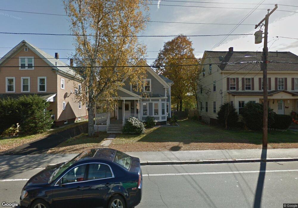
This home is located at 122 S Main St, Athol, MA 01331 and is currently estimated at $342,517, approximately $209 per square foot. 122 S Main St is a home located in Worcester County with nearby schools including Athol High School.
Ownership History
Date
Name
Owned For
Owner Type
Purchase Details
Closed on
Feb 15, 1996
Sold by
Fnma
Bought by
Vulter Thomas and Vulter Deborah
Current Estimated Value
Home Financials for this Owner
Home Financials are based on the most recent Mortgage that was taken out on this home.
Original Mortgage
$63,150
Interest Rate
6.99%
Mortgage Type
Purchase Money Mortgage
Purchase Details
Closed on
Nov 14, 1994
Sold by
Allaire Darius
Bought by
Federal National Mortgage Association
Purchase Details
Closed on
Sep 10, 1990
Sold by
Goodrich Linda J
Bought by
Allaire Darius K
Create a Home Valuation Report for This Property
The Home Valuation Report is an in-depth analysis detailing your home's value as well as a comparison with similar homes in the area
Home Values in the Area
Average Home Value in this Area
Purchase History
| Date | Buyer | Sale Price | Title Company |
|---|---|---|---|
| Vulter Thomas | $66,500 | -- | |
| Federal National Mortgage Association | $104,142 | -- | |
| Allaire Darius K | $180,900 | -- |
Source: Public Records
Mortgage History
| Date | Status | Borrower | Loan Amount |
|---|---|---|---|
| Open | Allaire Darius K | $71,000 | |
| Closed | Allaire Darius K | $63,150 | |
| Previous Owner | Allaire Darius K | $74,000 |
Source: Public Records
Tax History Compared to Growth
Tax History
| Year | Tax Paid | Tax Assessment Tax Assessment Total Assessment is a certain percentage of the fair market value that is determined by local assessors to be the total taxable value of land and additions on the property. | Land | Improvement |
|---|---|---|---|---|
| 2025 | $2,712 | $213,400 | $38,800 | $174,600 |
| 2024 | $2,680 | $208,900 | $38,800 | $170,100 |
| 2023 | $2,463 | $175,400 | $28,100 | $147,300 |
| 2022 | $2,236 | $139,300 | $26,800 | $112,500 |
| 2021 | $1,900 | $107,600 | $24,400 | $83,200 |
| 2020 | $3,932 | $102,100 | $22,100 | $80,000 |
| 2019 | $3,563 | $94,500 | $20,900 | $73,600 |
| 2018 | $3,389 | $84,900 | $19,000 | $65,900 |
| 2017 | $1,732 | $84,900 | $19,000 | $65,900 |
| 2016 | $1,664 | $83,900 | $19,000 | $64,900 |
| 2015 | $1,597 | $83,900 | $19,000 | $64,900 |
| 2014 | $1,546 | $83,900 | $19,000 | $64,900 |
Source: Public Records
Map
Nearby Homes
- 23 Mount Pleasant St
- 105 Freedom St
- 73 Fern St
- 182 Harrison St
- 193 Freedom St
- 53 Union St
- 305 S Athol Rd
- 315 S Athol Rd
- 330 N Orange Rd
- 106 Ridge Ave
- 133 Harvard Ave
- 3 Chestnut St
- 459 Fairview Ave
- 71 Wendell St
- 22 Charles Place
- 27 Warwick Ave
- 91 Cottage St Unit A
- 551 Sanders St
- 161 Prospect St
- 9 Kendall St