Estimated Value: $763,000 - $983,000
4
Beds
4
Baths
2,424
Sq Ft
$365/Sq Ft
Est. Value
About This Home
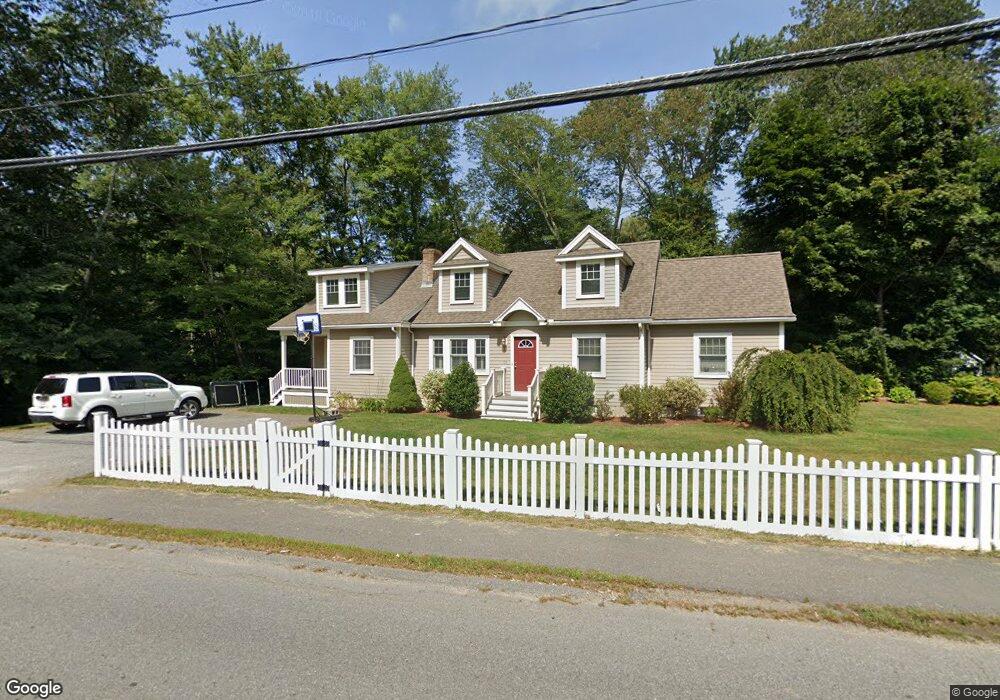
This home is located at 122 School St, Acton, MA 01720 and is currently estimated at $884,229, approximately $364 per square foot. 122 School St is a home located in Middlesex County with nearby schools including Acton-Boxborough Regional High School, Maynard Knowledge Beginnings, and The Imago School.
Ownership History
Date
Name
Owned For
Owner Type
Purchase Details
Closed on
Feb 15, 2024
Sold by
Hocknell Peter K and Hocknell Kimberly N
Bought by
122 School Street Rt and Hocknell
Current Estimated Value
Purchase Details
Closed on
Sep 30, 2002
Sold by
Gorman Nancy S and Arsenault Scott
Bought by
Hocknell Kimberly N and Hocknell Peter K
Purchase Details
Closed on
Apr 23, 1999
Sold by
Mellusi Joseph L
Bought by
Gorman Nancy S
Purchase Details
Closed on
May 31, 1996
Sold by
Grask Paul S and Grask Kathleen D
Bought by
Mellusi Joseph L and Mellusi Susan C
Create a Home Valuation Report for This Property
The Home Valuation Report is an in-depth analysis detailing your home's value as well as a comparison with similar homes in the area
Home Values in the Area
Average Home Value in this Area
Purchase History
| Date | Buyer | Sale Price | Title Company |
|---|---|---|---|
| 122 School Street Rt | -- | None Available | |
| Hocknell Kimberly N | $365,000 | -- | |
| Gorman Nancy S | $226,900 | -- | |
| Mellusi Joseph L | $167,000 | -- | |
| Mellusi Joseph L | $167,000 | -- |
Source: Public Records
Mortgage History
| Date | Status | Borrower | Loan Amount |
|---|---|---|---|
| Previous Owner | Mellusi Joseph L | $394,000 | |
| Previous Owner | Mellusi Joseph L | $409,000 |
Source: Public Records
Tax History
| Year | Tax Paid | Tax Assessment Tax Assessment Total Assessment is a certain percentage of the fair market value that is determined by local assessors to be the total taxable value of land and additions on the property. | Land | Improvement |
|---|---|---|---|---|
| 2025 | $14,255 | $831,200 | $312,000 | $519,200 |
| 2024 | $13,419 | $805,000 | $312,000 | $493,000 |
| 2023 | $13,639 | $776,700 | $283,700 | $493,000 |
| 2022 | $12,335 | $634,200 | $246,500 | $387,700 |
| 2021 | $11,924 | $589,400 | $228,200 | $361,200 |
| 2020 | $10,984 | $570,900 | $228,200 | $342,700 |
| 2019 | $10,545 | $544,400 | $228,200 | $316,200 |
| 2018 | $10,343 | $533,700 | $228,200 | $305,500 |
| 2017 | $10,172 | $533,700 | $228,200 | $305,500 |
| 2016 | $9,657 | $502,200 | $228,200 | $274,000 |
| 2015 | $9,515 | $499,500 | $228,200 | $271,300 |
| 2014 | $9,247 | $475,400 | $228,200 | $247,200 |
Source: Public Records
Map
Nearby Homes
- 70 River St
- 1 Vanderbelt Rd
- 30 Brewster Ln
- 7 Hillcrest Dr
- 40 High St
- 25 Nylander Way
- 129 Main St Unit 129
- 131 Main St
- 184 Main St Unit 3
- 130 Parker St Unit J2
- 7 Kelley Rd
- 31 Drummer Rd Unit 31
- 1 Drummer Rd Unit A5
- 246 Main St Unit 2
- 63 Conant St
- 59 Lexington Dr
- 27 Forest Rd
- 46 Taylor Rd
- 6 Beacon Ct
- 303 School St
Your Personal Tour Guide
Ask me questions while you tour the home.