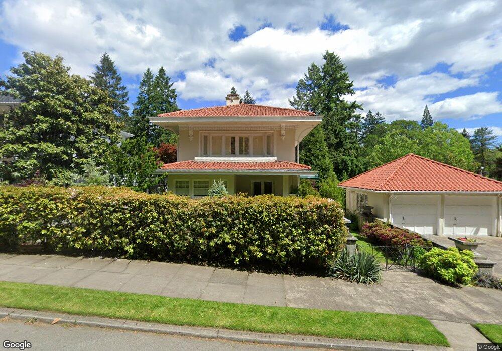
122 SW Marconi Ave Portland, OR 97205
Arlington Heights NeighborhoodEstimated Value: $1,570,277 - $1,789,000
4
Beds
4
Baths
3,370
Sq Ft
$493/Sq Ft
Est. Value
About This Home
This home is located at 122 SW Marconi Ave, Portland, OR 97205 and is currently estimated at $1,660,759, approximately $492 per square foot. 122 SW Marconi Ave is a home located in Multnomah County with nearby schools including Ainsworth Elementary School, West Sylvan Middle School, and Lincoln High School.
Ownership History
Date
Name
Owned For
Owner Type
Purchase Details
Closed on
Jul 3, 2012
Sold by
Nelson John Robert
Bought by
Howell Donna
Current Estimated Value
Home Financials for this Owner
Home Financials are based on the most recent Mortgage that was taken out on this home.
Original Mortgage
$417,000
Interest Rate
3.27%
Mortgage Type
New Conventional
Purchase Details
Closed on
Mar 27, 2007
Sold by
Ferriday David W
Bought by
Howell Donna
Create a Home Valuation Report for This Property
The Home Valuation Report is an in-depth analysis detailing your home's value as well as a comparison with similar homes in the area
Home Values in the Area
Average Home Value in this Area
Purchase History
| Date | Buyer | Sale Price | Title Company |
|---|---|---|---|
| Howell Donna | -- | Lawyers | |
| Howell Donna | -- | None Available | |
| Howell Donna | $1,272,500 | Lawyers Title Ins |
Source: Public Records
Mortgage History
| Date | Status | Borrower | Loan Amount |
|---|---|---|---|
| Previous Owner | Howell Donna | $417,000 |
Source: Public Records
Tax History Compared to Growth
Tax History
| Year | Tax Paid | Tax Assessment Tax Assessment Total Assessment is a certain percentage of the fair market value that is determined by local assessors to be the total taxable value of land and additions on the property. | Land | Improvement |
|---|---|---|---|---|
| 2024 | $22,920 | $857,460 | -- | -- |
| 2023 | $22,039 | $832,490 | $0 | $0 |
| 2022 | $21,562 | $808,250 | $0 | $0 |
| 2021 | $21,197 | $784,710 | $0 | $0 |
| 2020 | $19,444 | $761,860 | $0 | $0 |
| 2019 | $18,729 | $739,670 | $0 | $0 |
| 2018 | $18,178 | $718,130 | $0 | $0 |
| 2017 | $17,422 | $697,220 | $0 | $0 |
| 2016 | $15,943 | $676,920 | $0 | $0 |
| 2015 | $15,525 | $657,210 | $0 | $0 |
| 2014 | $15,291 | $638,070 | $0 | $0 |
Source: Public Records
Map
Nearby Homes
- 140 NW MacLeay Blvd
- 226 NW MacLeay Blvd
- 0 NW MacLeay Blvd Unit LOT 2 23235694
- 315 NW Uptown Terrace Unit 2B
- 2869 SW Champlain Dr
- 2376 SW Cedar St Unit 3
- 2933 SW Fairview Blvd
- 310 NW Uptown Terrace Unit 1A
- 413 NW Uptown Terrace Unit 2A
- 2336 SW Osage St Unit 402
- 335 NW Uptown Terrace Unit 2B
- 2393 SW Park Place Unit 210
- 2393 SW Park Place Unit 308
- 2393 SW Park Place Unit 106
- 2393 SW Park Place Unit 113
- 2351 NW Westover Rd Unit 1006
- 2351 NW Westover Rd Unit 312
- 2351 NW Westover Rd Unit 307
- 2351 NW Westover Rd Unit 906
- 2351 NW Westover Rd Unit 803
- 140 SW Marconi Ave
- 2620 SW Tichner Dr
- 115 SW Wright Ave
- 141 SW Wright Ave
- 208 SW Marconi Ave
- 160 SW Parkside Ln
- 214 SW Marconi Ave
- 211 SW Wright Ave
- 126 SW Parkside Ln
- 226 SW Parkside Dr
- 2633 SW Tichner Dr
- 2617 SW Tichner Dr
- 229 SW Wright Ave
- 236 SW Parkside Dr
- 232 SW Marconi Ave
- 216 SW Parkside Dr
- 138 SW Kingston Ave
- 242 SW Parkside Dr
- 2635 SW Park Place
- 2623 SW Park Place