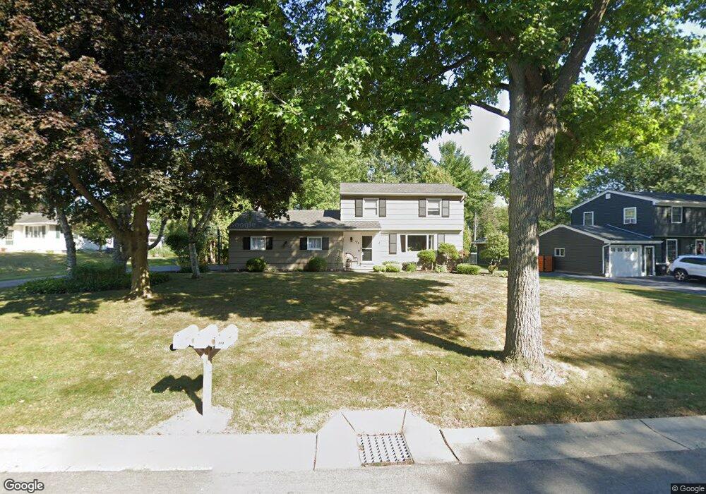
122 Thorncliff Rd Spencerport, NY 14559
Estimated Value: $287,064 - $319,000
3
Beds
2
Baths
1,708
Sq Ft
$176/Sq Ft
Est. Value
About This Home
This home is located at 122 Thorncliff Rd, Spencerport, NY 14559 and is currently estimated at $300,016, approximately $175 per square foot. 122 Thorncliff Rd is a home located in Monroe County with nearby schools including A M Cosgrove Middle School and Spencerport High School.
Ownership History
Date
Name
Owned For
Owner Type
Purchase Details
Closed on
Jul 19, 2016
Sold by
Wiggs Wayne G and Wiggs Colleen M
Bought by
Distaffen Katherine A
Current Estimated Value
Purchase Details
Closed on
Jun 15, 2000
Sold by
Grande Susan
Bought by
Wiggs Wayne G
Purchase Details
Closed on
May 9, 1997
Sold by
Matla Ronald and Matla Carolyn M
Bought by
Grande Susan
Create a Home Valuation Report for This Property
The Home Valuation Report is an in-depth analysis detailing your home's value as well as a comparison with similar homes in the area
Home Values in the Area
Average Home Value in this Area
Purchase History
| Date | Buyer | Sale Price | Title Company |
|---|---|---|---|
| Distaffen Katherine A | $140,000 | None Available | |
| Wiggs Wayne G | $118,500 | Joseph Interlichia | |
| Grande Susan | $115,000 | -- |
Source: Public Records
Tax History Compared to Growth
Tax History
| Year | Tax Paid | Tax Assessment Tax Assessment Total Assessment is a certain percentage of the fair market value that is determined by local assessors to be the total taxable value of land and additions on the property. | Land | Improvement |
|---|---|---|---|---|
| 2024 | $7,585 | $246,100 | $40,500 | $205,600 |
| 2023 | $6,789 | $140,000 | $30,500 | $109,500 |
| 2022 | $6,405 | $140,000 | $30,500 | $109,500 |
| 2021 | $6,265 | $140,000 | $30,500 | $109,500 |
| 2020 | $6,191 | $140,000 | $30,500 | $109,500 |
| 2019 | $5,460 | $140,000 | $30,500 | $109,500 |
| 2018 | $6,242 | $140,000 | $30,500 | $109,500 |
| 2017 | $3,238 | $133,100 | $30,500 | $102,600 |
| 2016 | $5,460 | $133,100 | $30,500 | $102,600 |
| 2015 | -- | $133,100 | $30,500 | $102,600 |
| 2014 | -- | $133,100 | $30,500 | $102,600 |
Source: Public Records
Map
Nearby Homes
- 76 Hawthorne Dr
- 326 Village Walk Cir
- 2283 S Union St
- 87 Highview Dr
- 24 Birdsong Terrace
- 49 Hillcrest Dr
- 154 Amity St
- 78 Clark St
- 0000 Bay Leaf Cir Lot#119
- 000
- 00 Bay Leaf Circle Lot#117
- 0 Unit R1620030
- 64 Coleman Ave
- 92 Coolidge Ave
- 28 Coolidge Ave
- 62 Clearview Dr
- 4028 Canal Rd
- 607 Trimmer Rd
- 15 Chambers St
- 3375 Brockport Spencerport Rd
- 116 Thorncliff Rd
- 128 Thorncliff Rd
- 145 Nichols St
- 110 Thorncliff Rd
- 123 Thorncliff Rd
- 137 Nichols St
- 161 Nichols St
- 119 Thorncliff Rd
- 94 Thorncliff Rd
- 115 Thorncliff Rd
- 131 Nichols St
- 111 Thorncliff Rd
- 88 Thorncliff Rd
- 119 Harwood Rd
- 171 Nichols St
- 107 Thorncliff Rd
- 125 Nichols St
- 134 Harwood Rd
- 138 Nichols St
- 82 Thorncliff Rd