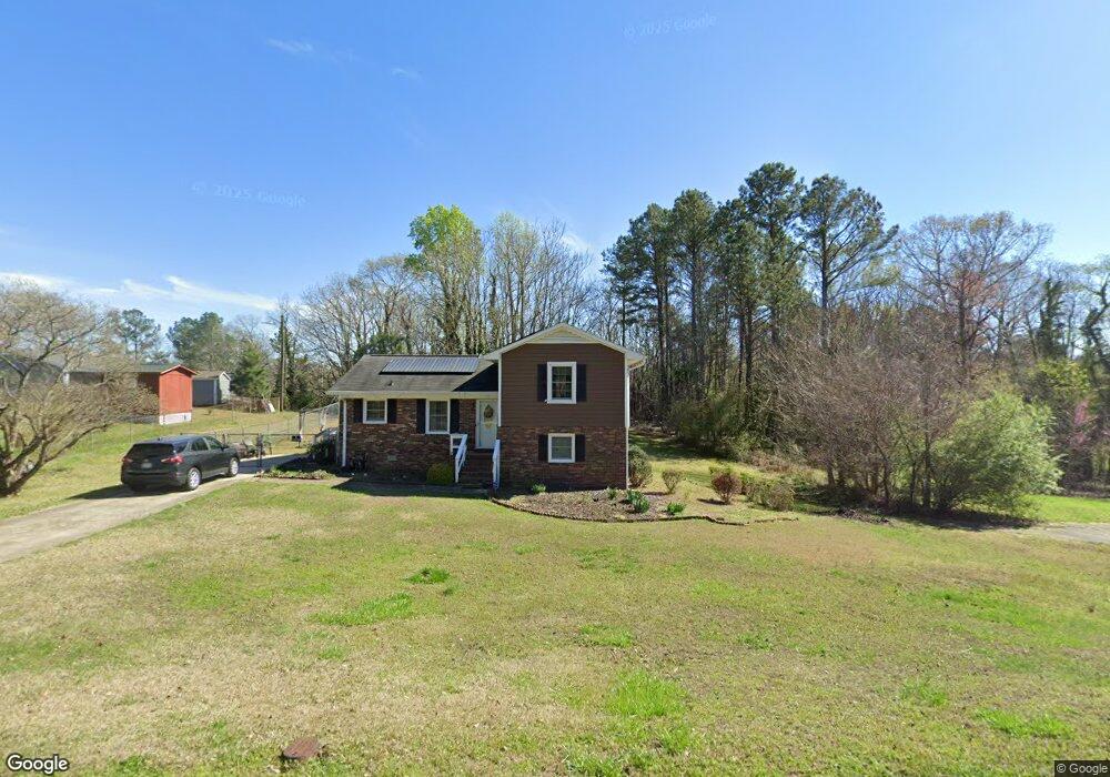
122 Unity Rd Spartanburg, SC 29307
Estimated Value: $177,365 - $201,000
4
Beds
2
Baths
1,406
Sq Ft
$132/Sq Ft
Est. Value
About This Home
This home is located at 122 Unity Rd, Spartanburg, SC 29307 and is currently estimated at $186,091, approximately $132 per square foot. 122 Unity Rd is a home located in Spartanburg County with nearby schools including Broome High School and Spartanburg Day School.
Ownership History
Date
Name
Owned For
Owner Type
Purchase Details
Closed on
Aug 11, 2020
Sold by
Giraudy Douglas
Bought by
Giraudy Douglas and Giraudy Willie Mae
Current Estimated Value
Purchase Details
Closed on
Apr 30, 2014
Sold by
Stubblefield Michael T and Stubblefield Gail T
Bought by
Giraudy Douglas
Home Financials for this Owner
Home Financials are based on the most recent Mortgage that was taken out on this home.
Original Mortgage
$61,200
Outstanding Balance
$46,711
Interest Rate
4.37%
Mortgage Type
New Conventional
Estimated Equity
$139,380
Create a Home Valuation Report for This Property
The Home Valuation Report is an in-depth analysis detailing your home's value as well as a comparison with similar homes in the area
Home Values in the Area
Average Home Value in this Area
Purchase History
| Date | Buyer | Sale Price | Title Company |
|---|---|---|---|
| Giraudy Douglas | -- | None Available | |
| Giraudy Douglas | $76,500 | -- |
Source: Public Records
Mortgage History
| Date | Status | Borrower | Loan Amount |
|---|---|---|---|
| Open | Giraudy Douglas | $61,200 |
Source: Public Records
Tax History Compared to Growth
Tax History
| Year | Tax Paid | Tax Assessment Tax Assessment Total Assessment is a certain percentage of the fair market value that is determined by local assessors to be the total taxable value of land and additions on the property. | Land | Improvement |
|---|---|---|---|---|
| 2025 | $445 | $4,047 | $665 | $3,382 |
| 2024 | $445 | $4,047 | $665 | $3,382 |
| 2023 | $445 | $4,047 | $665 | $3,382 |
| 2022 | $347 | $3,519 | $620 | $2,899 |
| 2021 | $347 | $3,519 | $620 | $2,899 |
| 2020 | $337 | $3,519 | $620 | $2,899 |
| 2019 | $379 | $3,519 | $620 | $2,899 |
| 2018 | $320 | $3,519 | $620 | $2,899 |
| 2017 | $228 | $3,060 | $540 | $2,520 |
| 2016 | $235 | $3,096 | $540 | $2,556 |
| 2015 | $542 | $3,060 | $540 | $2,520 |
| 2014 | $537 | $3,060 | $540 | $2,520 |
Source: Public Records
Map
Nearby Homes
- 655 Idlewood Cir
- 241 Idlewood Cir
- 249 Leeds Ln
- 250 Leeds Ln
- 270 Leeds Ln
- 268 Saranac Dr
- 276 Saranac Dr
- 9015 Margot Place
- 204 Bennett Dairy Rd
- Nassau Cove Plan at Berkeley - Villas
- 215 Penny Bennett Rd
- 9007 Margot Place
- 0 Old Converse Rd
- 9003 Margot Place
- 8007 Broadmead Ct
- 8019 Broadmead Ct
- 8023 Broadmead Ct
- Longspur Plan at Crestview
- Goldcrest Plan at Crestview
- Raven Plan at Crestview