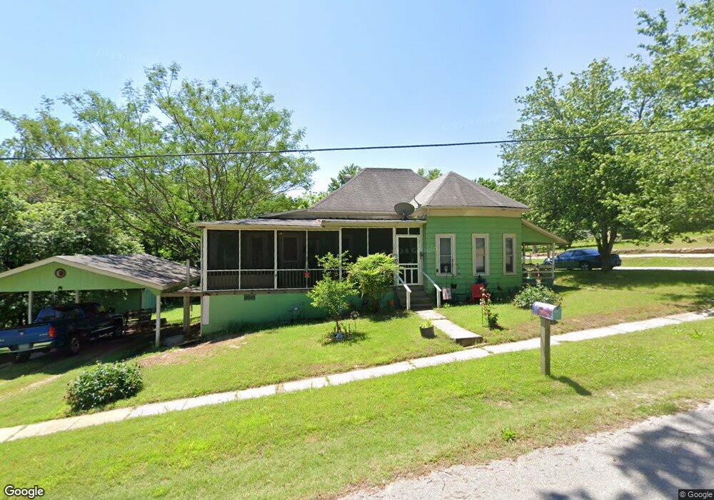
122 W 1st St Calico Rock, AR 72519
Estimated Value: $127,000 - $208,000
--
Bed
--
Bath
1,331
Sq Ft
$115/Sq Ft
Est. Value
About This Home
This home is located at 122 W 1st St, Calico Rock, AR 72519 and is currently estimated at $152,607, approximately $114 per square foot. 122 W 1st St is a home with nearby schools including Calico Rock Elementary School and Calico Rock High School.
Ownership History
Date
Name
Owned For
Owner Type
Purchase Details
Closed on
Jun 30, 2022
Sold by
Davison and Sue
Bought by
Watts Thurl and Watts Donna
Current Estimated Value
Purchase Details
Closed on
Apr 28, 2015
Sold by
Aimee Aimee
Bought by
Davison Wayne R and Davison Sue L
Purchase Details
Closed on
Feb 11, 2011
Sold by
Watts Thurl and Watts Donna
Bought by
Watts Aimee
Home Financials for this Owner
Home Financials are based on the most recent Mortgage that was taken out on this home.
Original Mortgage
$40,413
Interest Rate
4.7%
Mortgage Type
Future Advance Clause Open End Mortgage
Create a Home Valuation Report for This Property
The Home Valuation Report is an in-depth analysis detailing your home's value as well as a comparison with similar homes in the area
Home Values in the Area
Average Home Value in this Area
Purchase History
| Date | Buyer | Sale Price | Title Company |
|---|---|---|---|
| Watts Thurl | -- | Bray Eric | |
| Watts Thurl | -- | Bray Eric | |
| Davison Wayne R | $74,500 | -- | |
| Watts Aimee | -- | -- |
Source: Public Records
Mortgage History
| Date | Status | Borrower | Loan Amount |
|---|---|---|---|
| Previous Owner | Watts Aimee | $40,413 |
Source: Public Records
Tax History Compared to Growth
Tax History
| Year | Tax Paid | Tax Assessment Tax Assessment Total Assessment is a certain percentage of the fair market value that is determined by local assessors to be the total taxable value of land and additions on the property. | Land | Improvement |
|---|---|---|---|---|
| 2025 | $49 | $13,620 | $1,200 | $12,420 |
| 2024 | $149 | $13,620 | $1,200 | $12,420 |
| 2023 | $224 | $13,620 | $1,200 | $12,420 |
| 2022 | $649 | $13,620 | $1,200 | $12,420 |
| 2021 | $682 | $13,620 | $1,200 | $12,420 |
| 2020 | $649 | $12,180 | $1,000 | $11,180 |
| 2019 | $274 | $12,180 | $1,000 | $11,180 |
| 2018 | $649 | $12,180 | $1,000 | $11,180 |
| 2017 | $649 | $12,180 | $1,000 | $11,180 |
| 2016 | -- | $12,180 | $1,000 | $11,180 |
| 2015 | -- | $0 | $0 | $0 |
| 2014 | -- | $0 | $0 | $0 |
| 2013 | -- | $8,790 | $1,000 | $7,790 |
Source: Public Records
Map
Nearby Homes
- 64 South St
- 214 Mcvey Rd
- 100 Main St
- 770 White River Landing
- 611 Arkansas 56
- 2157 Pleasant Grove Rd
- 868 Highway 5
- 0 Chessmond Ferry Rd
- 1 Mullett's Landing Rd
- 8840 Arkansas 56
- 98 W Garden Ln
- 74 W Garden Ln
- 222 Culp Rd
- 000 N Boswell Rd
- Mill Creek Rd
- Calico St
- 109 Jones St
- 000 Cr 127
- 0 Haw Mountain Cemetery Rd Unit 25038364
- 150 Old Dolph Rd