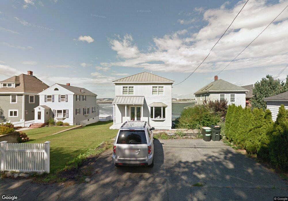
122 Wilson Rd Nahant, MA 01908
Estimated Value: $878,000 - $1,526,000
3
Beds
1
Bath
1,616
Sq Ft
$750/Sq Ft
Est. Value
About This Home
This home is located at 122 Wilson Rd, Nahant, MA 01908 and is currently estimated at $1,211,369, approximately $749 per square foot. 122 Wilson Rd is a home located in Essex County with nearby schools including Johnson Elementary School, Swampscott Middle School, and Swampscott High School.
Ownership History
Date
Name
Owned For
Owner Type
Purchase Details
Closed on
Jun 18, 2020
Sold by
Manadee Perry P and Manadee Panamai
Bought by
122 Wilson Road Rt and Manadee
Current Estimated Value
Purchase Details
Closed on
Nov 7, 2003
Sold by
Dill Daniel
Bought by
Jamgotchian Jane
Home Financials for this Owner
Home Financials are based on the most recent Mortgage that was taken out on this home.
Original Mortgage
$520,000
Interest Rate
6.01%
Mortgage Type
Purchase Money Mortgage
Purchase Details
Closed on
Jul 23, 2003
Sold by
122 Wilson Road Rt and Dill
Bought by
Dill Daniel
Home Financials for this Owner
Home Financials are based on the most recent Mortgage that was taken out on this home.
Original Mortgage
$200,000
Interest Rate
5.27%
Mortgage Type
Purchase Money Mortgage
Purchase Details
Closed on
Jul 1, 2003
Sold by
Leone Marion
Bought by
122 Wilson Road Rt and Dill-Tree
Home Financials for this Owner
Home Financials are based on the most recent Mortgage that was taken out on this home.
Original Mortgage
$200,000
Interest Rate
5.27%
Mortgage Type
Purchase Money Mortgage
Create a Home Valuation Report for This Property
The Home Valuation Report is an in-depth analysis detailing your home's value as well as a comparison with similar homes in the area
Home Values in the Area
Average Home Value in this Area
Purchase History
We collect this data history from publicly available records. To have your information removed, we recommend requesting removal directly through your county’s website.
| Date | Buyer | Sale Price | Title Company |
|---|---|---|---|
| 122 Wilson Road Rt | -- | None Available | |
| 122 Wilson Road Rt | -- | None Available | |
| Jamgotchian Jane | $525,000 | -- | |
| Jamgotchian Jane | $525,000 | -- | |
| Dill Daniel | -- | -- | |
| Dill Daniel | -- | -- | |
| 122 Wilson Road Rt | $500,000 | -- | |
| 122 Wilson Road Rt | $500,000 | -- |
Source: Public Records
Mortgage History
We collect this data history from publicly available records. To have your information removed, we recommend requesting removal directly through your county’s website.
| Date | Status | Borrower | Loan Amount |
|---|---|---|---|
| Previous Owner | Jamgotchian Jane | $520,000 | |
| Previous Owner | Dill Daniel | $200,000 |
Source: Public Records
Tax History
| Year | Tax Paid | Tax Assessment Tax Assessment Total Assessment is a certain percentage of the fair market value that is determined by local assessors to be the total taxable value of land and additions on the property. | Land | Improvement |
|---|---|---|---|---|
| 2025 | $11,571 | $1,264,600 | $729,000 | $535,600 |
| 2024 | $11,056 | $1,219,000 | $683,400 | $535,600 |
| 2023 | $10,116 | $1,112,900 | $601,400 | $511,500 |
| 2022 | $9,849 | $1,006,000 | $546,700 | $459,300 |
| 2021 | $9,792 | $931,700 | $501,200 | $430,500 |
| 2020 | $9,477 | $863,900 | $501,200 | $362,700 |
| 2019 | $8,505 | $779,600 | $455,600 | $324,000 |
| 2018 | $7,445 | $726,300 | $410,100 | $316,200 |
| 2017 | $7,667 | $732,300 | $410,100 | $322,200 |
| 2016 | $6,851 | $651,200 | $391,800 | $259,400 |
| 2015 | $6,762 | $619,200 | $364,000 | $255,200 |
| 2014 | $6,528 | $591,800 | $330,800 | $261,000 |
Source: Public Records
Map
Nearby Homes
- 250 Wilson Rd
- 51 Fox Hill Rd
- 66 Ocean St
- 43 Maple Ave
- 22 Sherman Ave
- 85 Willow Rd
- 1 Goddard Dr
- 5 Cottage St
- 303 Nahant Rd
- 162 Willow Rd Unit 11
- 6 Desmond Dr
- 98 Lynnway
- 150 Lynnway Unit 403
- 150 Lynnway Unit 702
- 150 Lynnway Unit 406
- 154 Lynnway Unit 210
- 154 Lynnway Unit 205
- 300 Lynn Shore Dr Unit 207
- 300 Lynn Shore Dr Unit 210
- 300 Lynn Shore Dr Unit 203
- 126 Wilson Rd
- 118 Wilson Rd
- 132 Wilson Rd
- 110 Wilson Rd
- 136 Wilson Rd
- 136 Wilson Rd Unit B
- 108 Wilson Rd
- 106 Wilson Rd
- 88 Wilson Rd Unit 92
- 88 Wilson Rd
- 88 Wilson Rd
- 88 Wilson Rd
- 129 Wilson Rd
- 129A Wilson Rd
- 138 Wilson Rd
- 138 Wilson Rd Unit 1
- 125 Wilson Rd
- 129A Wilson Rd
- 133 Wilson Rd Unit House
- 133 Wilson Rd
Your Personal Tour Guide
Ask me questions while you tour the home.