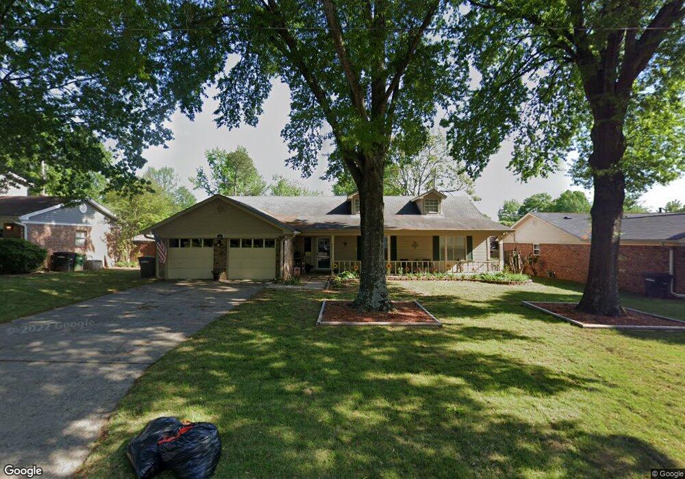
1220 Coolhurst Ave Sherwood, AR 72120
Estimated Value: $251,667 - $310,000
--
Bed
2
Baths
2,055
Sq Ft
$132/Sq Ft
Est. Value
About This Home
This home is located at 1220 Coolhurst Ave, Sherwood, AR 72120 and is currently estimated at $270,917, approximately $131 per square foot. 1220 Coolhurst Ave is a home located in Pulaski County with nearby schools including Sherwood Elementary School, Sylvan Hills Middle School, and Sylvan Hills High School.
Ownership History
Date
Name
Owned For
Owner Type
Purchase Details
Closed on
Apr 21, 2016
Sold by
Burmeister Richard A and Burmeister Mary A
Bought by
Dover Mary Jane and Dover Douglas Ray
Current Estimated Value
Purchase Details
Closed on
May 18, 2010
Sold by
Michaelsen Cynthia S and Michaelsen John C
Bought by
Burmeister Richard A and Burmeister Mary A
Home Financials for this Owner
Home Financials are based on the most recent Mortgage that was taken out on this home.
Original Mortgage
$166,822
Interest Rate
4.75%
Mortgage Type
FHA
Create a Home Valuation Report for This Property
The Home Valuation Report is an in-depth analysis detailing your home's value as well as a comparison with similar homes in the area
Home Values in the Area
Average Home Value in this Area
Purchase History
| Date | Buyer | Sale Price | Title Company |
|---|---|---|---|
| Dover Mary Jane | $172,900 | Realty Title | |
| Burmeister Richard A | $170,000 | Lenders Title Company |
Source: Public Records
Mortgage History
| Date | Status | Borrower | Loan Amount |
|---|---|---|---|
| Previous Owner | Burmeister Richard A | $166,822 |
Source: Public Records
Tax History Compared to Growth
Tax History
| Year | Tax Paid | Tax Assessment Tax Assessment Total Assessment is a certain percentage of the fair market value that is determined by local assessors to be the total taxable value of land and additions on the property. | Land | Improvement |
|---|---|---|---|---|
| 2025 | $1,631 | $42,281 | $6,400 | $35,881 |
| 2024 | $1,631 | $42,281 | $6,400 | $35,881 |
| 2023 | $1,631 | $42,281 | $6,400 | $35,881 |
| 2022 | $1,848 | $42,281 | $6,400 | $35,881 |
| 2021 | $1,781 | $31,300 | $6,000 | $25,300 |
| 2020 | $1,398 | $31,300 | $6,000 | $25,300 |
| 2019 | $1,398 | $31,300 | $6,000 | $25,300 |
| 2018 | $1,423 | $31,300 | $6,000 | $25,300 |
| 2017 | $1,422 | $31,300 | $6,000 | $25,300 |
| 2016 | $1,448 | $31,810 | $5,200 | $26,610 |
| 2015 | $1,616 | $31,810 | $5,200 | $26,610 |
| 2014 | $1,616 | $31,810 | $5,200 | $26,610 |
Source: Public Records
Map
Nearby Homes
- 609 Newcastle Dr
- 1300 Stafford Rd
- 619 Newcastle Dr
- 1301 Stafford Rd
- 618 & 620 Newcastle Dr
- 615 & 617 Brierly Dr
- 615 Brierly Dr
- 1406 Coolhurst Ave
- 622 Newcastle Dr
- +/- 8.16 Acres Windchime Ave
- 626 Newcastle Dr
- 1415 Stafford Rd
- 1419 Stafford Rd
- 11 Daniel Dr
- 1423 Stafford Rd
- 1501 Stafford Rd
- +/- 21.56 Acres Stafford Rd
- 1800 Palomino Dr
- 300 Burntwood Rd
- 8000 Pinto Trail
- 515 Pembroke Dr
- 1212 Coolhurst Ave
- 1219 Coolhurst Ave
- 1223 Coolhurst Ave
- 1213 Coolhurst Ave
- 1224 Essex Ln
- 1220 Essex Ln
- 0 Essex Ln
- 1227 Coolhurst Ave
- 1300 Coolhurst Ave
- 1216 Essex Ln
- 1207 Coolhurst Ave
- 1300 Chesterfield Dr
- 1208 Coolhurst Ave
- 1212 Essex Ln
- 1301 Coolhurst Ave
- 1304 Coolhurst Ave
- 1302 Chesterfield Dr
- 1216 Cornflower Ln
- 1208 Essex Ln