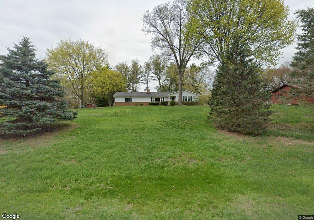
1220 Jeffrey Ln Saline, MI 48176
Estimated Value: $320,000 - $405,000
2
Beds
2
Baths
1,448
Sq Ft
$248/Sq Ft
Est. Value
About This Home
This home is located at 1220 Jeffrey Ln, Saline, MI 48176 and is currently estimated at $359,137, approximately $248 per square foot. 1220 Jeffrey Ln is a home located in Washtenaw County with nearby schools including Pleasant Ridge Elementary School, Heritage School, and Saline Middle School.
Ownership History
Date
Name
Owned For
Owner Type
Purchase Details
Closed on
Feb 7, 2025
Sold by
Walda Vicki
Bought by
Walda Vicki and Walda Kevin Christopher
Current Estimated Value
Purchase Details
Closed on
Oct 8, 2020
Sold by
Brown Helen M and Brown Roy
Bought by
Brown Helen M and Brown James R
Purchase Details
Closed on
Dec 11, 2018
Sold by
Brown Helen M and Brown Roy
Bought by
Brown Helen M and Saline Jeffrey Lane
Purchase Details
Closed on
Apr 24, 2017
Sold by
Brown Helen M and Brown Roy
Bought by
Walda Vicki S and Brown James R
Create a Home Valuation Report for This Property
The Home Valuation Report is an in-depth analysis detailing your home's value as well as a comparison with similar homes in the area
Home Values in the Area
Average Home Value in this Area
Purchase History
| Date | Buyer | Sale Price | Title Company |
|---|---|---|---|
| Walda Vicki | -- | None Listed On Document | |
| Walda Vicki | -- | None Listed On Document | |
| Brown Helen M | -- | None Available | |
| Brown Helen M | -- | None Available | |
| Walda Vicki S | -- | None Available |
Source: Public Records
Tax History Compared to Growth
Tax History
| Year | Tax Paid | Tax Assessment Tax Assessment Total Assessment is a certain percentage of the fair market value that is determined by local assessors to be the total taxable value of land and additions on the property. | Land | Improvement |
|---|---|---|---|---|
| 2025 | $4,187 | $150,600 | $0 | $0 |
| 2024 | $3,591 | $135,600 | $0 | $0 |
| 2023 | $3,426 | $123,000 | $0 | $0 |
| 2022 | $3,220 | $115,600 | $0 | $0 |
| 2021 | $3,134 | $113,300 | $0 | $0 |
| 2020 | $3,088 | $110,900 | $0 | $0 |
| 2019 | $3,014 | $103,300 | $103,300 | $0 |
| 2018 | $2,947 | $98,600 | $0 | $0 |
| 2017 | $2,814 | $98,400 | $0 | $0 |
| 2016 | $2,363 | $82,800 | $0 | $0 |
| 2015 | -- | $82,600 | $0 | $0 |
| 2014 | -- | $80,100 | $0 | $0 |
| 2013 | -- | $80,100 | $0 | $0 |
Source: Public Records
Map
Nearby Homes
- 9037 Yorkshire Dr
- 9370 Moon Rd
- 9001 Yorkshire Dr
- 9003 York Crest Dr
- 9002 York Crest Dr
- 9187 Charter Oak Ln
- 9004 Charter Oak Ln
- 9559 Sherwood Dr
- 9935 White Tail Dr
- 9931 White Tail Dr
- 758 Sutton Ct
- 834 Meghan Ct
- 762 Sutton Ct
- 754 Sutton Ct
- 6081 Lincolnshire Dr
- 1623 Wildwood Ln
- 290 Shelby Ct Unit 6
- 5075 Rutland Dr
- 5071 Rutland Dr
- Decker Plan at Fosdick Glen of Saline - Toll Brothers at Fosdick Glen