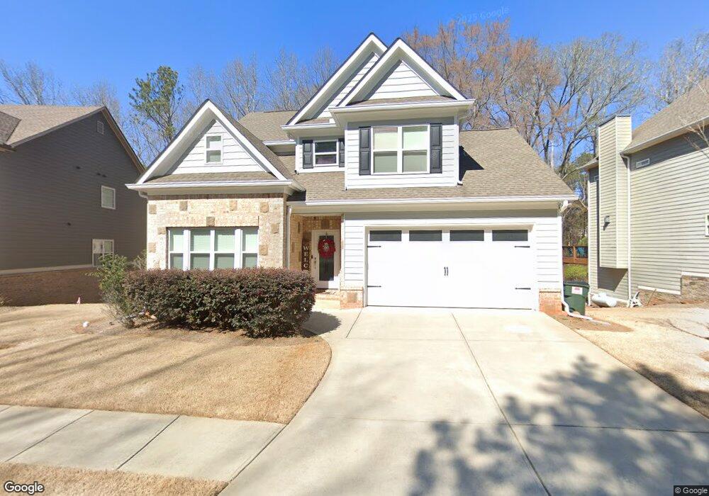
1220 Livingston Trail Unit 10 Bogart, GA 30622
Estimated Value: $475,940 - $603,000
3
Beds
4
Baths
2,169
Sq Ft
$258/Sq Ft
Est. Value
About This Home
This home is located at 1220 Livingston Trail Unit 10, Bogart, GA 30622 and is currently estimated at $558,735, approximately $257 per square foot. 1220 Livingston Trail Unit 10 is a home located in Oconee County with nearby schools including Malcom Bridge Elementary School, Malcom Bridge Middle School, and North Oconee High School.
Ownership History
Date
Name
Owned For
Owner Type
Purchase Details
Closed on
Dec 11, 2018
Sold by
Carswell Josh
Bought by
Wheeler Benjamin Patt and Wheeler Stevi Denise
Current Estimated Value
Home Financials for this Owner
Home Financials are based on the most recent Mortgage that was taken out on this home.
Original Mortgage
$315,000
Outstanding Balance
$277,001
Interest Rate
4.9%
Mortgage Type
New Conventional
Estimated Equity
$281,734
Purchase Details
Closed on
Feb 19, 2015
Sold by
Sias Grp Inc
Bought by
Carswell Joshua H and Carswell Kacie Anne
Home Financials for this Owner
Home Financials are based on the most recent Mortgage that was taken out on this home.
Original Mortgage
$232,900
Interest Rate
3.74%
Mortgage Type
New Conventional
Create a Home Valuation Report for This Property
The Home Valuation Report is an in-depth analysis detailing your home's value as well as a comparison with similar homes in the area
Home Values in the Area
Average Home Value in this Area
Purchase History
| Date | Buyer | Sale Price | Title Company |
|---|---|---|---|
| Wheeler Benjamin Patt | $340,000 | -- | |
| Carswell Joshua H | $275,000 | -- |
Source: Public Records
Mortgage History
| Date | Status | Borrower | Loan Amount |
|---|---|---|---|
| Open | Wheeler Benjamin Patt | $315,000 | |
| Previous Owner | Carswell Joshua H | $232,900 |
Source: Public Records
Tax History Compared to Growth
Tax History
| Year | Tax Paid | Tax Assessment Tax Assessment Total Assessment is a certain percentage of the fair market value that is determined by local assessors to be the total taxable value of land and additions on the property. | Land | Improvement |
|---|---|---|---|---|
| 2024 | $3,259 | $176,628 | $30,000 | $146,628 |
| 2023 | $3,263 | $176,622 | $18,000 | $158,622 |
| 2022 | $3,326 | $157,035 | $18,000 | $139,035 |
| 2021 | $3,280 | $143,695 | $18,000 | $125,695 |
| 2020 | $2,990 | $130,958 | $16,000 | $114,958 |
| 2019 | $2,732 | $119,836 | $16,000 | $103,836 |
| 2018 | $2,686 | $115,387 | $16,000 | $99,387 |
| 2017 | $2,390 | $102,893 | $16,000 | $86,893 |
| 2016 | $2,452 | $105,542 | $16,000 | $89,542 |
| 2015 | $1,377 | $58,016 | $14,000 | $44,016 |
| 2014 | $153 | $6,300 | $6,300 | $0 |
| 2013 | -- | $4,760 | $4,760 | $0 |
Source: Public Records
Map
Nearby Homes
- 1021 Bedford Trail
- 1105 Harperfield Dr
- 2165 Harperfield Dr
- 3164 Malcom Estates Dr
- 1479 Mcfall Ct
- 6601 Hog Mountain Hwy - Hwy 53 Unit PARCEL B
- 1081 Julian Dr Unit 4
- 1081 Julian Dr
- 1020 Timber Ridge Rd
- 1071 Oaklake Cir
- 1010 Garland Dr
- 0 Us 78 Hwy
- 1 Us 78 Hwy
- 1100 Manjula Ln
- 1175 Manjula Ln
- 1300 Manjula Ln
- 0 Whitehead Rd Unit CL335631
- 0 Whitehead Rd Unit 10574962
- 1010 Long Creek Dr
- 1010 Oaklake Terrace
- 1220 Livingston Trail
- 1210 Livingston Trail
- 1230 Livingston Trail
- 1200 Livingston Trail
- 1240 Livingston Trail
- 1190 Livingston Trail
- 1250 Livingston Trail
- 1180 Livingston Trail
- 0 Livingston Trail Unit 7519776
- 0 Livingston Trail Unit 7519461
- 0 Livingston Trail Unit 7395076
- 0 Livingston Trail Unit 7395060
- 0 Livingston Trail Unit 7343451
- 0 Livingston Trail Unit 7332577
- 0 Livingston Trail Unit 7088875
- 0 Livingston Trail Unit 7088869
- 0 Livingston Trail Unit 7088861
- 0 Livingston Trail Unit 7088857
- 0 Livingston Trail Unit 7088842
- 0 Livingston Trail Unit 7562582