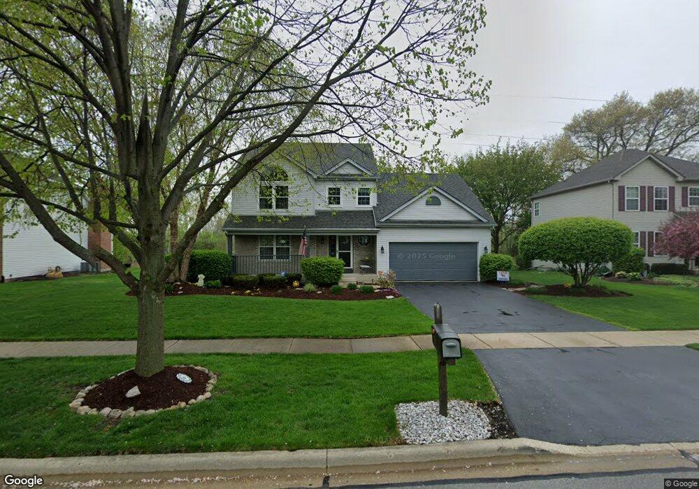
1220 Thomas Dr West Chicago, IL 60185
Chicago West NeighborhoodEstimated Value: $395,608 - $502,000
3
Beds
3
Baths
2,225
Sq Ft
$208/Sq Ft
Est. Value
About This Home
This home is located at 1220 Thomas Dr, West Chicago, IL 60185 and is currently estimated at $462,652, approximately $207 per square foot. 1220 Thomas Dr is a home located in DuPage County with nearby schools including Wegner Elementary School, Leman Middle School, and West Chicago Community High School.
Ownership History
Date
Name
Owned For
Owner Type
Purchase Details
Closed on
May 2, 2011
Sold by
Kochniarczyk Donald Jerome and Kochniarczyk Kathleen M
Bought by
Kochniarczyk Donald J and Kochniarczyk Kathleen M
Current Estimated Value
Purchase Details
Closed on
Oct 15, 1998
Sold by
Alan Dale Homes Corp
Bought by
Kochniarczyk Donald J and Kochniarczyk Kathleen M
Home Financials for this Owner
Home Financials are based on the most recent Mortgage that was taken out on this home.
Original Mortgage
$165,000
Outstanding Balance
$36,063
Interest Rate
6.88%
Estimated Equity
$426,589
Purchase Details
Closed on
May 18, 1998
Sold by
Wegner Land & Development Corp
Bought by
Alan Dale Homes Corp
Home Financials for this Owner
Home Financials are based on the most recent Mortgage that was taken out on this home.
Original Mortgage
$216,000
Interest Rate
8.5%
Mortgage Type
Construction
Create a Home Valuation Report for This Property
The Home Valuation Report is an in-depth analysis detailing your home's value as well as a comparison with similar homes in the area
Home Values in the Area
Average Home Value in this Area
Purchase History
| Date | Buyer | Sale Price | Title Company |
|---|---|---|---|
| Kochniarczyk Donald J | -- | None Available | |
| Kochniarczyk Donald J | $184,500 | Law Title | |
| Alan Dale Homes Corp | $54,000 | -- |
Source: Public Records
Mortgage History
| Date | Status | Borrower | Loan Amount |
|---|---|---|---|
| Open | Kochniarczyk Donald J | $165,000 | |
| Previous Owner | Alan Dale Homes Corp | $216,000 | |
| Closed | Alan Dale Homes Corp | $1,035,000 |
Source: Public Records
Tax History
| Year | Tax Paid | Tax Assessment Tax Assessment Total Assessment is a certain percentage of the fair market value that is determined by local assessors to be the total taxable value of land and additions on the property. | Land | Improvement |
|---|---|---|---|---|
| 2024 | $8,603 | $113,384 | $31,920 | $81,464 |
| 2023 | $8,012 | $102,870 | $28,960 | $73,910 |
| 2022 | $7,709 | $92,960 | $26,910 | $66,050 |
| 2021 | $7,348 | $88,250 | $25,550 | $62,700 |
| 2020 | $7,162 | $85,600 | $24,780 | $60,820 |
| 2019 | $7,823 | $90,710 | $26,260 | $64,450 |
| 2018 | $7,597 | $86,800 | $25,130 | $61,670 |
| 2017 | $7,463 | $83,340 | $24,130 | $59,210 |
| 2016 | $7,947 | $84,530 | $23,050 | $61,480 |
| 2015 | $7,940 | $80,020 | $21,820 | $58,200 |
| 2014 | $7,765 | $77,990 | $21,270 | $56,720 |
| 2013 | $7,777 | $79,860 | $21,780 | $58,080 |
Source: Public Records
Map
Nearby Homes
- 1102 Lillian Ln Unit 167
- Lot 15 Route 59 Hwy
- Lot 14 Route 59 Hwy
- 28W185 Lot 2 Geneva Rd
- 28W185 Lot 1 Geneva Rd
- Lot 16 Route 59 Hwy
- Lot 13 Route 59 Hwy
- 201 Amber Ct
- 840 Arbor Ave
- 2N660 Valewood Rd
- LOT 10 Grandlake Blvd
- 1 St Charles Rd
- 1066 Trillium Trail
- 31W780 North Ave
- 800 Ingalton Ave
- 30W680 Lee Rd
- 1335 Nagel Ct
- 2060 Arapaho Dr
- 29W548 Cape Ave
- 1N655 Ingalton Ave
Your Personal Tour Guide
Ask me questions while you tour the home.