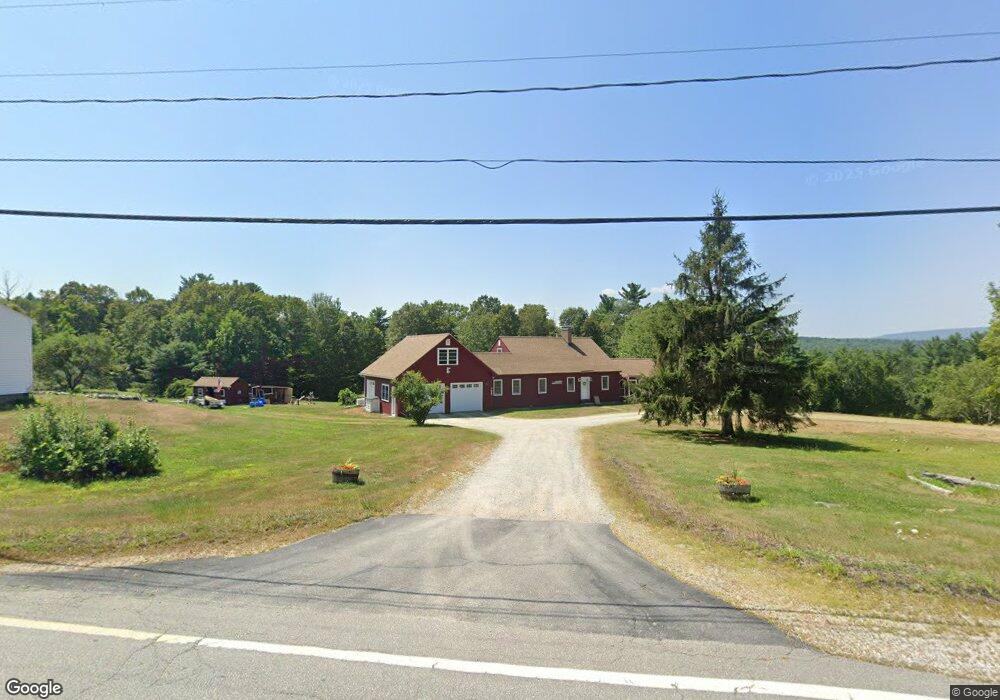
1221 Battle St Webster, NH 03303
Estimated Value: $527,000 - $633,000
2
Beds
2
Baths
2,646
Sq Ft
$215/Sq Ft
Est. Value
About This Home
This home is located at 1221 Battle St, Webster, NH 03303 and is currently estimated at $569,695, approximately $215 per square foot. 1221 Battle St is a home located in Merrimack County with nearby schools including Webster Elementary School, Merrimack Valley Middle School, and Merrimack Valley High School.
Ownership History
Date
Name
Owned For
Owner Type
Purchase Details
Closed on
Feb 29, 2016
Sold by
Clark John E and Clark Kelly A
Bought by
John John E and John Kelly R
Current Estimated Value
Purchase Details
Closed on
Aug 9, 1996
Sold by
Anderson Dean A
Bought by
Goddard Kelly A
Home Financials for this Owner
Home Financials are based on the most recent Mortgage that was taken out on this home.
Original Mortgage
$110,250
Interest Rate
8.24%
Create a Home Valuation Report for This Property
The Home Valuation Report is an in-depth analysis detailing your home's value as well as a comparison with similar homes in the area
Home Values in the Area
Average Home Value in this Area
Purchase History
| Date | Buyer | Sale Price | Title Company |
|---|---|---|---|
| John John E | -- | -- | |
| Goddard Kelly A | $112,500 | -- |
Source: Public Records
Mortgage History
| Date | Status | Borrower | Loan Amount |
|---|---|---|---|
| Previous Owner | Goddard Kelly A | $126,000 | |
| Previous Owner | Goddard Kelly A | $25,000 | |
| Previous Owner | Goddard Kelly A | $150,000 | |
| Previous Owner | Goddard Kelly A | $110,250 |
Source: Public Records
Tax History
| Year | Tax Paid | Tax Assessment Tax Assessment Total Assessment is a certain percentage of the fair market value that is determined by local assessors to be the total taxable value of land and additions on the property. | Land | Improvement |
|---|---|---|---|---|
| 2025 | $7,908 | $468,500 | $108,600 | $359,900 |
| 2024 | $7,276 | $468,500 | $108,600 | $359,900 |
| 2023 | $6,971 | $468,500 | $108,600 | $359,900 |
| 2022 | $6,782 | $296,800 | $78,600 | $218,200 |
| 2021 | $6,553 | $294,000 | $78,600 | $215,400 |
| 2020 | $106 | $294,000 | $78,600 | $215,400 |
| 2019 | $107 | $294,000 | $78,600 | $215,400 |
| 2018 | $105 | $293,600 | $78,600 | $215,000 |
| 2017 | $6,124 | $266,600 | $56,700 | $209,900 |
| 2016 | $6,124 | $266,600 | $56,700 | $209,900 |
| 2015 | $6,420 | $266,600 | $56,700 | $209,900 |
| 2014 | $6,042 | $266,300 | $56,700 | $209,600 |
| 2013 | $5,787 | $266,300 | $56,700 | $209,600 |
Source: Public Records
Map
Nearby Homes
- 11 White Plains Rd
- 350 South Rd
- 437 High St
- 25 Merrill Corner Rd
- 122 Centennial Dr
- M10 L05 S37 Centennial Dr
- 233 Hensmith Rd
- 17 Centennial Dr
- 30 Centennial Dr
- 20 Water St
- Map 10 Dr
- 298 Battle St
- 84 New Hampshire Dr Unit 4
- Map 25 Lot 4 Hensmith Rd
- Map 25 Lot 5 Hensmith Rd
- Map25 Lot 7 Hensmith Rd
- Map 25 Lot 3 Hensmith Rd
- Map 25 Lot 6 Hensmith Rd
- 66 New Hampshire Dr
- 19 Bailey Dr
Your Personal Tour Guide
Ask me questions while you tour the home.