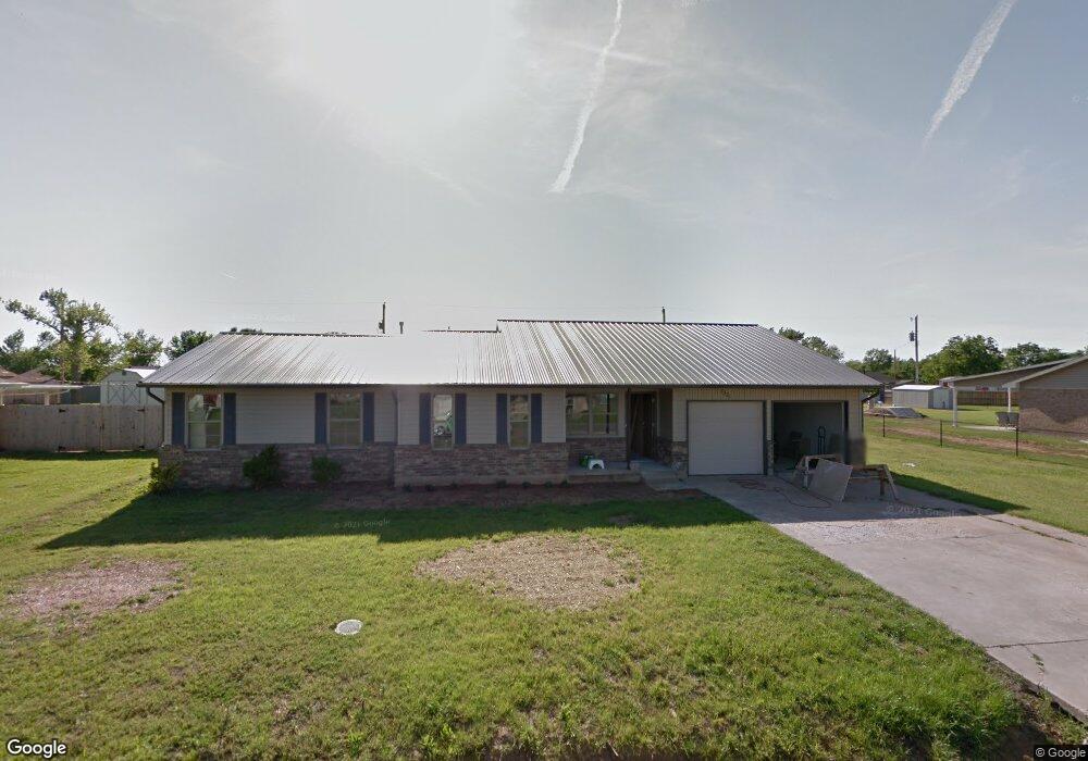
1221 N Doris Ave Newcastle, OK 73065
Estimated Value: $211,000 - $265,000
3
Beds
2
Baths
1,757
Sq Ft
$138/Sq Ft
Est. Value
About This Home
This home is located at 1221 N Doris Ave, Newcastle, OK 73065 and is currently estimated at $243,253, approximately $138 per square foot. 1221 N Doris Ave is a home located in McClain County with nearby schools including Newcastle Elementary School, Newcastle Middle School, and Newcastle High School.
Ownership History
Date
Name
Owned For
Owner Type
Purchase Details
Closed on
Oct 31, 2015
Sold by
Bryan Chesley and Bryan Suzanne E
Bought by
Hight Larry G and Hight Loretta A
Current Estimated Value
Purchase Details
Closed on
Jul 28, 2011
Sold by
Conway Jeff T and Conway Shari
Bought by
Bryan Chesley and Bryan Suzanne E
Purchase Details
Closed on
Feb 26, 2007
Sold by
Obrien Michael and Obrien Jan M
Bought by
Conway Jeff T and Conway Shari
Home Financials for this Owner
Home Financials are based on the most recent Mortgage that was taken out on this home.
Original Mortgage
$26,500
Interest Rate
6.25%
Mortgage Type
Stand Alone Second
Purchase Details
Closed on
Aug 13, 1998
Sold by
Mendez Robert and Mendez Kathryn
Bought by
Brien Michael O and Brien John
Create a Home Valuation Report for This Property
The Home Valuation Report is an in-depth analysis detailing your home's value as well as a comparison with similar homes in the area
Home Values in the Area
Average Home Value in this Area
Purchase History
| Date | Buyer | Sale Price | Title Company |
|---|---|---|---|
| Hight Larry G | -- | None Available | |
| Bryan Chesley | $10,000 | None Available | |
| Conway Jeff T | -- | None Available | |
| Brien Michael O | $75,500 | -- |
Source: Public Records
Mortgage History
| Date | Status | Borrower | Loan Amount |
|---|---|---|---|
| Previous Owner | Conway Jeff T | $26,500 | |
| Previous Owner | Conway Jeff T | $79,500 |
Source: Public Records
Tax History Compared to Growth
Tax History
| Year | Tax Paid | Tax Assessment Tax Assessment Total Assessment is a certain percentage of the fair market value that is determined by local assessors to be the total taxable value of land and additions on the property. | Land | Improvement |
|---|---|---|---|---|
| 2025 | $2,036 | $19,324 | $1,241 | $18,083 |
| 2024 | $2,036 | $18,762 | $1,205 | $17,557 |
| 2023 | $2,036 | $18,215 | $1,100 | $17,115 |
| 2022 | $1,926 | $17,684 | $1,100 | $16,584 |
| 2021 | $1,959 | $17,169 | $1,100 | $16,069 |
| 2020 | $1,906 | $16,669 | $1,100 | $15,569 |
| 2019 | $1,875 | $16,184 | $1,100 | $15,084 |
| 2018 | $1,789 | $15,713 | $1,100 | $14,613 |
| 2017 | $1,730 | $15,255 | $1,100 | $14,155 |
| 2016 | $1,683 | $14,811 | $1,100 | $13,711 |
| 2015 | $1,677 | $13,760 | $1,100 | $12,660 |
| 2014 | $1,576 | $13,105 | $1,100 | $12,005 |
Source: Public Records
Map
Nearby Homes
- 1109 N Doris Ave
- 1100 N Doris Ave
- 1013 N Carr Dr
- 375 NE 9th Place
- 303 Naomi Ln
- 1657 Autumn Lane Ct
- 1009 NW 17th St
- 808 Saint James Place
- 908 NW 6th St
- 1019 NW 17th St
- 820 NW 5th St
- 1116 Vermont Ave
- 1165 NW 17th St
- 1009 NW 5th St
- 1132 NW 17th Place
- 1012 NW 5th St
- 1733 Pine Brook
- 501 Saint James Place
- Springfield Plan at Wyndemere
- Zion Plan at Wyndemere
- 1305 N Doris Ave
- 1213 N Doris Ave
- 1220 N Melinda Ave
- 1304 N Melinda Ave
- 1212 N Melinda Ave
- 1309 N Doris Ave
- 1268 N Doris Ave
- 1205 N Doris Ave
- 1302 N Doris Ave
- 1220 N Doris Ave
- 1304 N Doris Ave
- 1312 N Melinda Ave
- 1204 N Melinda Ave
- 1235 N Doris Ave
- 903 N Doris Ave
- 1312 N Doris Ave
- 1204 N Doris Ave
- 1121 N Doris Ave
- 1120 N Melinda Ave
- 1120 N Doris Ave