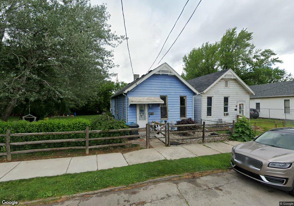
1221 N Michigan St Toledo, OH 43604
Lagrange NeighborhoodEstimated Value: $40,000 - $51,552
3
Beds
1
Bath
960
Sq Ft
$48/Sq Ft
Est. Value
About This Home
This home is located at 1221 N Michigan St, Toledo, OH 43604 and is currently estimated at $46,517, approximately $48 per square foot. 1221 N Michigan St is a home located in Lucas County with nearby schools including Riverside Elementary School, Woodward High School, and The Maritime Academy of Toledo.
Ownership History
Date
Name
Owned For
Owner Type
Purchase Details
Closed on
Jun 8, 2017
Sold by
Burris Candi M and Morales Candi M
Bought by
Morales Louis S and Morales Candi M
Current Estimated Value
Purchase Details
Closed on
May 15, 2001
Sold by
Clements Randy
Bought by
Burris Candi M
Home Financials for this Owner
Home Financials are based on the most recent Mortgage that was taken out on this home.
Original Mortgage
$17,038
Interest Rate
7.02%
Mortgage Type
FHA
Purchase Details
Closed on
Aug 6, 1996
Sold by
Fitch Anita N
Bought by
Clements Randy
Create a Home Valuation Report for This Property
The Home Valuation Report is an in-depth analysis detailing your home's value as well as a comparison with similar homes in the area
Home Values in the Area
Average Home Value in this Area
Purchase History
| Date | Buyer | Sale Price | Title Company |
|---|---|---|---|
| Morales Louis S | -- | None Available | |
| Burris Candi M | $17,000 | Louisville Title Agency For | |
| Clements Randy | $500 | -- |
Source: Public Records
Mortgage History
| Date | Status | Borrower | Loan Amount |
|---|---|---|---|
| Closed | Burris Candi M | $17,038 |
Source: Public Records
Tax History Compared to Growth
Tax History
| Year | Tax Paid | Tax Assessment Tax Assessment Total Assessment is a certain percentage of the fair market value that is determined by local assessors to be the total taxable value of land and additions on the property. | Land | Improvement |
|---|---|---|---|---|
| 2024 | $421 | $7,140 | $4,900 | $2,240 |
| 2023 | $983 | $7,140 | $4,935 | $2,205 |
| 2022 | $858 | $7,140 | $4,935 | $2,205 |
| 2021 | $848 | $7,140 | $4,935 | $2,205 |
| 2020 | $892 | $5,950 | $4,095 | $1,855 |
| 2019 | $837 | $5,950 | $4,095 | $1,855 |
| 2018 | $662 | $5,950 | $4,095 | $1,855 |
| 2017 | $841 | $5,810 | $1,820 | $3,990 |
| 2016 | $458 | $15,100 | $3,700 | $11,400 |
| 2015 | $455 | $15,100 | $3,700 | $11,400 |
| 2014 | $333 | $5,290 | $1,300 | $3,990 |
| 2013 | $333 | $5,290 | $1,300 | $3,990 |
Source: Public Records
Map
Nearby Homes
- 1238 N Ontario St
- 1431 N Michigan St
- 1463 N Ontario St
- 811 Bush St
- 809 Bush St
- 624 Bush St
- 1114 N Superior St
- 1449 N Superior St
- 721 Stickney Ave
- 522 Locust St
- 1631 N Erie St
- 1510 Walnut St
- 1029 Sherman St
- 1219 Peck St
- 1130 Page St
- 1431 Moore St
- 1721 Walnut St
- 2017 Locust St
- 2005 Walnut St
- 1307 Noble St
- 1223 N Michigan St
- 1229 N Michigan St
- 1213 N Michigan St
- 1233 N Michigan St
- 1209 N Michigan St
- 913 Mulberry St
- 1230 N Michigan St Unit 4
- 1230 N Michigan St
- 1224 N Michigan St
- 1220 N Michigan St
- 1226 N Michigan St
- 1228 N Michigan St
- 823 Mulberry St
- 821 Mulberry St
- 820 Chestnut St
- 817 Mulberry St
- 1303 N Michigan St
- 818 Chestnut St
- 914 Mulberry St
- 1139 N Michigan St