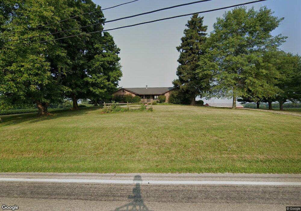
1221 N State Route 61 Sunbury, OH 43074
Estimated Value: $466,000 - $1,417,553
3
Beds
3
Baths
2,212
Sq Ft
$426/Sq Ft
Est. Value
About This Home
This home is located at 1221 N State Route 61, Sunbury, OH 43074 and is currently estimated at $941,777, approximately $425 per square foot. 1221 N State Route 61 is a home located in Delaware County with nearby schools including General Rosecrans Elementary School, Big Walnut Intermediate School, and Big Walnut Middle School.
Ownership History
Date
Name
Owned For
Owner Type
Purchase Details
Closed on
Jun 2, 2021
Sold by
May Mcdannald Kathrine
Bought by
Revocable Trust
Current Estimated Value
Purchase Details
Closed on
Feb 19, 2021
Sold by
May Mcdannald Kathrine
Bought by
Revocable Trust
Purchase Details
Closed on
Mar 3, 2014
Sold by
Mcdonald Ray E and Mcdonald Kathrine M
Bought by
Mcdannald Ray R and Revocable Trust Of Ray E Mcdon
Create a Home Valuation Report for This Property
The Home Valuation Report is an in-depth analysis detailing your home's value as well as a comparison with similar homes in the area
Home Values in the Area
Average Home Value in this Area
Purchase History
| Date | Buyer | Sale Price | Title Company |
|---|---|---|---|
| Revocable Trust | -- | -- | |
| Revocable Trust | -- | -- | |
| Mcdannald Ray R | -- | None Available | |
| Mcdannald Kathrine M | -- | None Available |
Source: Public Records
Tax History Compared to Growth
Tax History
| Year | Tax Paid | Tax Assessment Tax Assessment Total Assessment is a certain percentage of the fair market value that is determined by local assessors to be the total taxable value of land and additions on the property. | Land | Improvement |
|---|---|---|---|---|
| 2024 | $87,525 | $727,520 | $592,660 | $134,860 |
| 2023 | $8,848 | $727,520 | $592,660 | $134,860 |
| 2022 | $7,439 | $589,300 | $466,410 | $122,890 |
| 2021 | $7,476 | $589,300 | $466,410 | $122,890 |
| 2020 | $7,505 | $589,300 | $466,410 | $122,890 |
| 2019 | $7,818 | $484,690 | $388,680 | $96,010 |
| 2018 | $7,365 | $484,690 | $388,680 | $96,010 |
| 2017 | $7,101 | $466,940 | $387,280 | $79,660 |
| 2016 | $7,137 | $466,940 | $387,280 | $79,660 |
| 2015 | $7,181 | $466,940 | $387,280 | $79,660 |
| 2014 | $7,444 | $466,940 | $387,280 | $79,660 |
| 2013 | $5,436 | $466,940 | $387,280 | $79,660 |
Source: Public Records
Map
Nearby Homes
- 956 N State Route 61
- 732 N State Route 61
- 202 N Columbus St
- 408 Village Ln
- 0 W Cherry St
- 0 Kintner Pkwy
- 8790 Devon Ridge Ct
- 0 Hartford Rd Unit 8.17 acres 225016432
- 300 Fox Trail Dr
- 2100 Blayney Rd
- 0 Ohio 37 Unit 225026227
- 12433 Ohio 37
- 320 E Cherry St
- 285 E Cherry St
- 0 N State Route 61 Unit Lot 4 225027787
- 0 N State Route 61 Unit Lot 3 225027777
- 0 N State Route 61 Unit Lot 2 225027762
- 561 Fields Meadow Dr
- 761 Buckeye Cir Unit Lot 2392
- 349 Laurel Ct
- 2290 State Route 61
- 3620 State Route 61
- 0-1 State Route 61
- 1020 N State Route 61
- 3500 State Route 61
- 1015 N State Route 61
- 963 N State Route 61
- 980 N State Route 61
- 927 N State Route 61
- 1407 Ohio 61
- 1022 N State Route 61
- 901 N State Route 61
- 1447 N State Route 61
- 880 N State Route 61
- 811 N State Route 61
- 1487 N State Route 61
- 1483 N State Route 61
- 1460 N State Route 61
- 734 Prairie Run Dr
- 674 Prairie Run Dr